Turkey elevation
On our site we have elevation data and maps for 1914 cities from Turkey including Ankara as capital of the country.
Turkey on topographic map
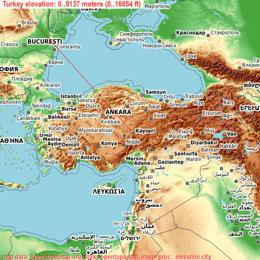
Turkey elevation extremes
Land surface elevation extremes in Turkey:
- Highest point in Turkey: Mount Ararat with 5137 meters (=16854 ft)
- Lowest point: Mediterranean Sea, Black Sea with 0 meters (=0 ft)
- Elevation span: 5137 m (=16854 ft)
Statistics
- Main average elevation: 1132 meters (= 3714 ft)
- Average elevation of cities: 723 m (= 2372 ft), and this is 327 m (1073 ft) above average city elevation worldwide..[1]
- Area: 780,580 km² (= 301,384 sq mi)
- Population: 77,804,122


This is only the list of largest 150 cities in ABC order:
If the city you are looking for is not listed, use the search box above.
Search by letter:
A B C D E F G H I K L M N O P R S T U V Y Z
A:
Adana Adapazarı Adıyaman Afyonkarahisar Ağrı Ahlat Akhisar Aksaray Akşehir Alanya Amasya Ankara Antakya Antalya Ardeşen Arnavutköy Ataşehir Aydın Ayvalık
B:
Bafra Bağcılar Bahçelievler Balıkesir Bandırma Başakşehir Batikent Batman Belek Beylikdüzü Bingöl Bismil Bolu Büyükçekmece Burdur Bursa
C:
Çanakkale Çankaya Çerkezköy Ceyhan Cizre Çorlu Çorum Çubuk
D:
Denizli Derince Diyarbakır Doğubayazıt
E:
Edirne Elazığ Elbistan Erciş Ereğli Ereğli Erzincan Erzurum Esenler Esenyurt Eskişehir
F:
Fatsa Fethiye
G:
Gaziantep Gebze Gemlik Giresun
H:
Hakkâri
I:
Iğdır İnegol İskenderun Isparta Istanbul İzmir İzmit
K:
Kadirli Kahramanmaraş Kâhta Karabağlar Karabük Karaman Kars Kastamonu Kayseri Khanjarah Kilis Kırıkhan Kırıkkale Kırklareli Kırşehir Kızıltepe Konya Körfez Kozan Kuşadası Kütahya
L:
Lüleburgaz
M:
Malatya Maltepe Manavgat Manisa Mardin Merkezefendi Mersin Midyat Muratpaşa Muş Mustafakemalpaşa
N:
Nazilli Nevşehir Niğde Nizip Nusaybin
O:
Ödemiş Ordu Osmaniye
P:
Patnos Polatlı
R:
Rize
S:
Salihli Samsun Sancaktepe Şanlıurfa Siirt Silifke Silopi Silvan Şişli Sivas Siverek Söke Soma Sorgun Sultanbeyli Sultangazi
T:
Tarsus Tatvan Tekirdağ Tokat Trabzon Turgutlu Turhal
U:
Ünye Üsküdar Umraniye Uşak
V:
Van Viranşehir
Y:
Yalova Yozgat Yüksekova
Z:
Zeytinburnu Zonguldak
15 most populated cities are in red/bold font style.

A:
Adana Adapazarı Adıyaman Afyonkarahisar Ağrı Ahlat Akhisar Aksaray Akşehir Alanya Amasya Ankara Antakya Antalya Ardeşen Arnavutköy Ataşehir Aydın Ayvalık
B:
Bafra Bağcılar Bahçelievler Balıkesir Bandırma Başakşehir Batikent Batman Belek Beylikdüzü Bingöl Bismil Bolu Büyükçekmece Burdur Bursa
C:
Çanakkale Çankaya Çerkezköy Ceyhan Cizre Çorlu Çorum Çubuk
D:
Denizli Derince Diyarbakır Doğubayazıt
E:
Edirne Elazığ Elbistan Erciş Ereğli Ereğli Erzincan Erzurum Esenler Esenyurt Eskişehir
F:
Fatsa Fethiye
G:
Gaziantep Gebze Gemlik Giresun
H:
Hakkâri
I:
Iğdır İnegol İskenderun Isparta Istanbul İzmir İzmit
K:
Kadirli Kahramanmaraş Kâhta Karabağlar Karabük Karaman Kars Kastamonu Kayseri Khanjarah Kilis Kırıkhan Kırıkkale Kırklareli Kırşehir Kızıltepe Konya Körfez Kozan Kuşadası Kütahya
L:
Lüleburgaz
M:
Malatya Maltepe Manavgat Manisa Mardin Merkezefendi Mersin Midyat Muratpaşa Muş Mustafakemalpaşa
N:
Nazilli Nevşehir Niğde Nizip Nusaybin
O:
Ödemiş Ordu Osmaniye
P:
Patnos Polatlı
R:
Rize
S:
Salihli Samsun Sancaktepe Şanlıurfa Siirt Silifke Silopi Silvan Şişli Sivas Siverek Söke Soma Sorgun Sultanbeyli Sultangazi
T:
Tarsus Tatvan Tekirdağ Tokat Trabzon Turgutlu Turhal
U:
Ünye Üsküdar Umraniye Uşak
V:
Van Viranşehir
Y:
Yalova Yozgat Yüksekova
Z:
Zeytinburnu Zonguldak
Sources
- Elevation extremes by country from wikipedia.
- Base map data: © OpenStreetMap contributors, | map style: © OpenTopoMap (CC-BY-SA)
- [1] Calculated only from 1914 cities in our database
- Other city data from geonames.org with taken over terms of usage.
- Min/max latitude and longitude coordinates per country from latitudelongitude.org website.