Tokat elevation
Tokat, Turkey elevation is 627 meters and Tokat elevation in feet is 2057 ft above sea level [src 1]. Tokat is a seat of a first-order administrative division (feature code) with elevation that is 96 meters (315 ft) smaller than average city elevation in Turkey.
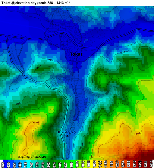
Below is the Elevation map of Tokat, which displays elevation range with different colors. Scale of the first map is from 588 to 1413 m (1929 to 4636 ft) with average elevation of 801.3 meters (=2629 ft) [note 1]
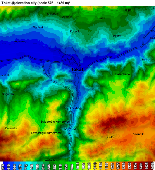
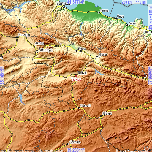
These maps also provides idea of topography and contour of this city, they are displayed at different zoom levels. More info about maps, scale and edge coordinates you can find below images.
| \ | Map #1 | Map #2 | Topo.Map |
| Scale [m] | 588..1413 m | 576..1459 m | × |
| Scale [ft] | 1929..4636 ft | 1890..4787 ft | × |
| Average | 801.3 m = 2629 ft | 904.3 m = 2967 ft | × |
| Width | 7.45 km = 4.6 mi | 14.9 km = 9.3 mi | 238.4 km = 148.1 mi |
| Height | 7.45 km = 4.6 mi | 14.9 km = 9.3 mi | 238.4 km = 148.1 mi |
| ↑Max Latitude | 40.34739° | 40.380874° | 41.37764° |
| Latitude at center | 40.31389° | 40.31389° | 40.31389° |
| ↓Min Latitude | 40.280373° | 40.246839° | 39.23311° |
| ← Min Longitude | 36.510495° | 36.466549° | 35.14819° |
| Longitude center | 36.55444° | 36.55444° | 36.55444° |
| →Max Longitude | 36.598385° | 36.642331° | 37.96069° |
Nearby cities:
Cities around Tokat sort by population:
• Turhal elevation 538 m
40.9 km,  281°
281°
• Erbaa 253 m
39.5 km,  1°
1°
• Yeşilyurt 574 m
17.3 km, 275°
• Almus 848 m
30.4 km,  76°
76°
• Artova 1182 m
30.8 km,  224°
224°
• Pazar 576 m
23.4 km,  259°
259°
• Çırçır 1349 m
34.3 km,  146°
146°
• Gökçeli 693 m
33.6 km,  26°
26°
• Kozlu 928 m
33.4 km,  348°
348°
• Çamlıbel 1125 m
26.1 km,  194°
194°
• Gökdere 746 m
24.4 km,  43°
43°
• Dökmetepe 561 m
22.3 km,  269°
269°
Multilingual:
 En español:
Provincia de Tokat elevación 627 m.
 En France:
Tokat élévation 627 m.


Sources and notes:
- [note 1] Map square and city borders are not equal. Map elevation data is calculated only from area inside that square.
- [src 1] Elevation data from geonames database provided with same terms of usage.
- [src 2] The elevation map of Tokat is generated using elevation data from NASA's 3 arcsec (90m) resolution SRTM data.
- [src 3] Base (background) map © OpenStreetMap contributors tiles are generated by Geofabrik and OpenTopoMap.
Copyright & License:
This Tokat Elevation Map is licensed under CC BY-SA. You may reuse any part from this page, if you give a proper credit by linking to this URL:
 More info on terms of use page.