Artova elevation
Artova (Tokat), Turkey elevation is 1182 meters and Artova elevation in feet is 3878 ft above sea level [src 1]. Artova is a seat of a second-order administrative division (feature code) with elevation that is 459 meters (1506 ft) bigger than average city elevation in Turkey.
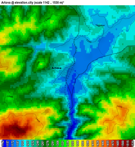
Below is the Elevation map of Artova, which displays elevation range with different colors. Scale of the first map is from 1142 to 1530 m (3747 to 5020 ft) with average elevation of 1276.5 meters (=4188 ft) [note 1]
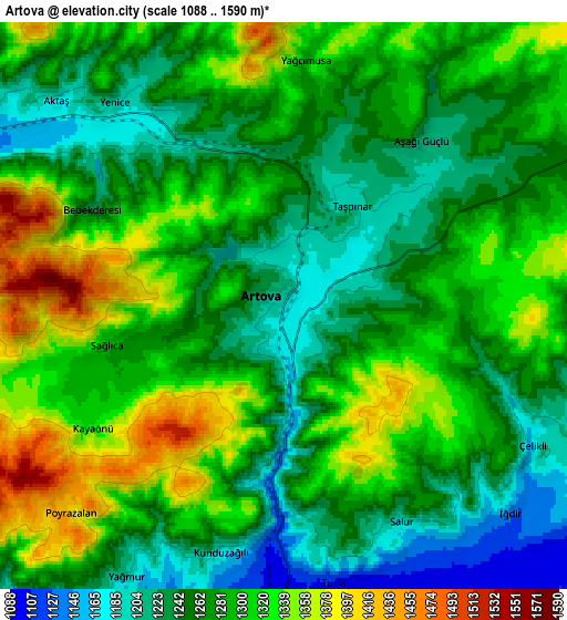
These maps also provides idea of topography and contour of this city, they are displayed at different zoom levels. More info about maps, scale and edge coordinates you can find below images.
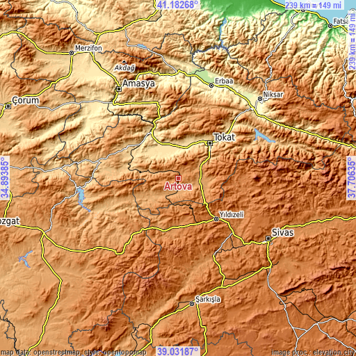
| \ | Map #1 | Map #2 | Topo.Map |
| Scale [m] | 1142..1530 m | 1088..1590 m | × |
| Scale [ft] | 3747..5020 ft | 3570..5217 ft | × |
| Average | 1276.5 m = 4188 ft | 1281.2 m = 4203 ft | × |
| Width | 7.47 km = 4.6 mi | 14.95 km = 9.3 mi | 239.1 km = 148.6 mi |
| Height | 7.47 km = 4.6 mi | 14.95 km = 9.3 mi | 239.1 km = 148.6 mi |
| ↑Max Latitude | 40.149379° | 40.182961° | 41.18268° |
| Latitude at center | 40.11578° | 40.11578° | 40.11578° |
| ↓Min Latitude | 40.082165° | 40.048533° | 39.03187° |
| ← Min Longitude | 36.256155° | 36.212209° | 34.89385° |
| Longitude center | 36.3001° | 36.3001° | 36.3001° |
| →Max Longitude | 36.344045° | 36.387991° | 37.70635° |
Nearby cities:
Cities around Artova sort by population:
• Tokat elevation 627 m
30.8 km,  44°
44°
• Turhal 538 m
35.5 km,  328°
328°
• Zile 746 m
40.8 km,  300°
300°
• Yeşilyurt 574 m
24 km,  10°
10°
• Pazar 576 m
17.9 km,  355°
355°
• Sulusaray 1037 m
22.8 km,  233°
233°
• Yıldızeli 1365 m
37.6 km,  137°
137°
• Yavu 1199 m
36.9 km,  192°
192°
• Boztepe 782 m
36 km,  282°
282°
• Dökmetepe 561 m
21.9 km, 358°
• Çamlıbel 1125 m
15.4 km,  102°
102°
• Yeşilyurt 1080 m
13.9 km,  209°
209°
Multilingual:
 En español:
Artova elevación 1182 m.
 En France:
Artova élévation 1182 m.


Sources and notes:
- [note 1] Map square and city borders are not equal. Map elevation data is calculated only from area inside that square.
- [src 1] Elevation data from geonames database provided with same terms of usage.
- [src 2] The elevation map of Artova is generated using elevation data from NASA's 3 arcsec (90m) resolution SRTM data.
- [src 3] Base (background) map © OpenStreetMap contributors tiles are generated by Geofabrik and OpenTopoMap.
Copyright & License:
This Artova Elevation Map is licensed under CC BY-SA. You may reuse any part from this page, if you give a proper credit by linking to this URL:
 More info on terms of use page.