Elevation statistics, facts
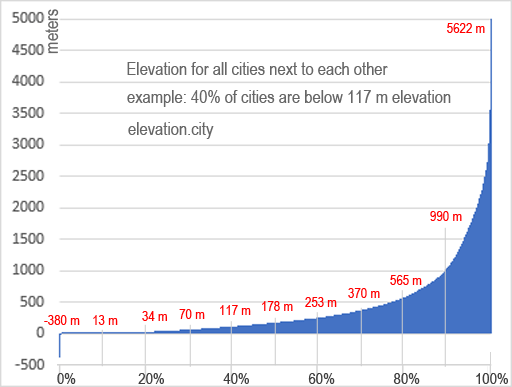
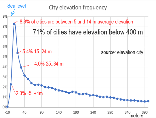
On elevation.city there are exactly 134,954 cities with average elevation of 396.36 meters = 1300 feet. Capitals has average elevation of 322.92 m = 1059 ft. 8.3% of cities has average altitude between 5 and 14 meters (see the graph). Interesting fact is that 2.3% of cities (3064 city from our database) are around sea level, between -5 and 4 m (*but this doesn't mean, that they are located next to the sea).
Cities with highest elevation (in our database):
- Zongga, CN elevation: 5,622 m = 18,445 ft
- Qiangqinxue, CN elevation: 5,381 m = 17,654 ft
- La Rinconada, PE elevation: 5,022 m = 16,476 ft
- Racaka, CN elevation: 5,015 m = 16,453 ft
- Lobujya, NP elevation: 4,972 m = 16,312 ft
- Gyamotang, CN elevation: 4,955 m = 16,257 ft
- Maindong, CN elevation: 4,899 m = 16,073 ft
- Condoroma, PE elevation: 4,803 m = 15,758 ft
- Antauta, PE elevation: 4,775 m = 15,666 ft
- Santa Bárbara, BO elevation: 4,732 m = 15,525 ft
Cities with lowest elevation:
- ‘En Boqeq, IL elevation: -380 m = -1,247 ft
- Safi, JO elevation: -366 m = -1,201 ft
- Ghawr al Mazra‘ah, JO elevation: -346 m = -1,135 ft
- Az Zubaydāt, PS elevation: -261 m = -856 ft
- Al Karāmah, JO elevation: -255 m = -837 ft
- Al Faşāyil, PS elevation: -251 m = -823 ft
- Al Jiftlik, PS elevation: -246 m = -807 ft
- Al ‘Awjā, PS elevation: -241 m = -791 ft
- Ash Shūnah al Janūbīyah, JO elevation: -233 m = -764 ft
- Jericho, PS elevation: -233 m = -764 ft
Capitals with highest elevation:
- Quito, EC elevation: 2,854 m = 9,364 ft
- Sucre, BO elevation: 2,798 m = 9,180 ft
- Bogotá, CO elevation: 2,582 m = 8,471 ft
- Addis Ababa, ET elevation: 2,405 m = 7,890 ft
- Asmara, ER elevation: 2,334 m = 7,657 ft
- Thimphu, BT elevation: 2,307 m = 7,569 ft
- Sanaa, YE elevation: 2,253 m = 7,392 ft
- Mexico City, MX elevation: 2,240 m = 7,349 ft
- Gitega, BI elevation: 1,849 m = 6,066 ft
- Kabul, AF elevation: 1,798 m = 5,899 ft
- Nairobi, KE elevation: 1,684 m = 5,525 ft
Capitals with lowest elevation:
- Baku, AZ elevation: -23 m = -75 ft
- Philipsburg, SX elevation: 0 m = 0 ft
- Longyearbyen, SJ elevation: 1 m = 3 ft
- Stanley, FK elevation: 1 m = 3 ft
- Basseterre, KN elevation: 1 m = 3 ft
- Tórshavn, FO elevation: 1 m = 3 ft
- Nuuk, GL elevation: 1 m = 3 ft
- Port-Vila, VU elevation: 1 m = 3 ft
- Willemstad, CW elevation: 1 m = 3 ft
- Port Moresby, PG elevation: 1 m = 3 ft
- Colombo, LK elevation: 1 m = 3 ft
Countries with maximal highest points:
- China and Nepal with Mount Everest as highest point with 8,848 meters (29,029 ft) above sea level.
- Pakistan: K2 with 8,611 meters (28,251 ft)
Countries with highest minimal elevation:
- Lesotho with minimal elevation of 1,400 m = 4,593 ft.
- Rwanda minimal elevation at 950 m = 3,117 ft (Ruzizi River)
- Andorra min. elevation: 840 m = 2,756 ft (Gran Valira)
Country with maximal average main elevation: Bhutan 3,280 m = 10,761 ft
Countries with most cities in the database:
- United States with 16,679 cities
- Italy with 9,941 cities
- Mexico with 8,984 cities
- France with 8,836 cities
- Germany with 7,183 cities
- Spain with 6,967 cities
- Russia with 4,659 cities
Countries with highest average city elevation:
- Peru with 2,321 meters =7,615 ft (calculated from 1291 cities)
- Ethiopia with 1,896 meters =6,220 ft (108 cities)
- Bolivia with 1,876 meters =6,155 ft (128 cities)
- Lesotho with 1,766 meters =5,794 ft (12 cities)
Values from graph on index page:
| meters | city elevation | land elevation | Ratio City/Land |
|---|---|---|---|
| -500..-1 | 0.29047% | 0.89641% | 24.5 / 75.5% |
| 0..499 | 76.27932% | 52.97355% | 59 / 41% |
| 500..999 | 12.65616% | 18.70749% | 40.4 / 59.6% |
| 1000..1499 | 4.36519% | 10.55028% | 29.3 / 70.7% |
| 1500..1999 | 2.96101% | 4.80669% | 38.1 / 61.9% |
| 2000..2499 | 1.96808% | 3.32348% | 37.2 / 62.8% |
| 2500..2999 | 0.89512% | 2.61201% | 25.5 / 74.5% |
| 3000..3499 | 0.29936% | 2.20918% | 11.9 / 88.1% |
| 3500..3999 | 0.19710% | 1.41560% | 12.2 / 87.8% |
| 4000..4499 | 0.06298% | 0.89651% | 6.6 / 93.4% |
| 4500..4999 | 0.02223% | 0.54512% | 3.9 / 96.1% |
| 5000..5499 | 0.00222% | 0.64806% | 0.3 / 99.7% |
| 5500..5999 | 0.00074% | 0.32690% | 0.2 / 99.8% |
| 6000..6499 | 0% | 0.07852% | 0 / 100% |
| 6500..6999 | 0% | 0.00924% | 0 / 100% |
| 7000..7499 | 0% | 0.00072% | 0 / 100% |
| 7500..7999 | 0% | 0.00018% | 0 / 100% |
| 8000..8499 | 0% | 0.00004% | 0 / 100% |
| 8500..8999 | 0% | 0.00001% | 0 / 100% |
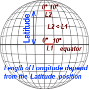 Values for land elevation are calculated from SRTM (Shuttle Radar Topography Mission) provided by NASA. Since data are provded on equirectangular map projection, where one tile (and pixel) has same vertical and horizontal dimension in DEGREES, but they are not equal to area measured in kilometers. Longitude length reduction is calculated in function from latitude with equation:
$longReduction = distance($Latitude,0,$Latitude,10) / distance(0,0,0,10);
This means length of 10° longitude at equator divided by 10° longitude at actual latitude position (closer to poles 10° is smaller than 10°at equator), where "distance()" is a function for calculation distance between two Lat,Long coordinates. Function is provided by 1km.net website.
Values for city elevation are calculated from all cities in database on this site.