Mexico City elevation
Mexico City, Mexico elevation is 2240 meters and Mexico City elevation in feet is 7349 ft above sea level [src 1]. Mexico City is a capital of a political entity (feature code) with elevation that is 926 meters (3038 ft) bigger than average city elevation in Mexico.
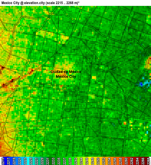
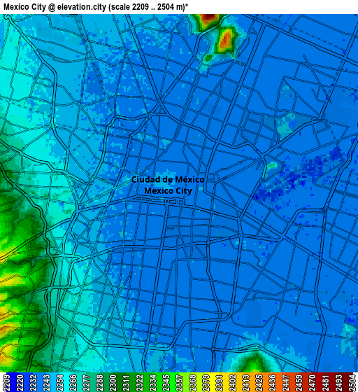
Below is the Elevation map of Mexico City, which displays elevation range with different colors. Scale of the first map is from 2215 to 2268 m (7267 to 7441 ft) with average elevation of 2239.2 meters (=7346 ft) [note 1]
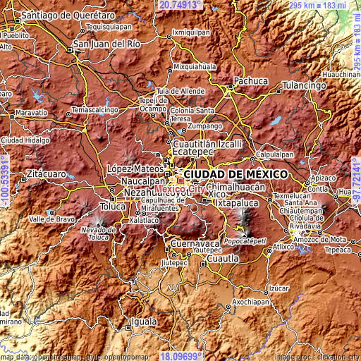
These maps also provides idea of topography and contour of this city, they are displayed at different zoom levels. More info about maps, scale and edge coordinates you can find below images.
| \ | Map #1 | Map #2 | Topo.Map |
| Scale [m] | 2215..2268 m | 2209..2504 m | × |
| Scale [ft] | 7267..7441 ft | 7247..8215 ft | × |
| Average | 2239.2 m = 7346 ft | 2249.9 m = 7382 ft | × |
| Width | 9.22 km = 5.7 mi | 18.43 km = 11.5 mi | 294.9 km = 183.2 mi |
| Height | 9.22 km = 5.7 mi | 18.43 km = 11.5 mi | 294.9 km = 183.2 mi |
| ↑Max Latitude | 19.469908° | 19.511335° | 20.74913° |
| Latitude at center | 19.42847° | 19.42847° | 19.42847° |
| ↓Min Latitude | 19.387022° | 19.345563° | 18.09699° |
| ← Min Longitude | -99.171605° | -99.215551° | -100.53391° |
| Longitude center | -99.12766° | -99.12766° | -99.12766° |
| →Max Longitude | -99.083715° | -99.039769° | -97.72141° |
Nearby cities:
Cities around Mexico City sort by population:
• Gustavo Adolfo Madero elevation 2284 m
7.5 km,  13°
13°
• Cuauhtémoc 2237 m
2.7 km,  313°
313°
• Venustiano Carranza 2235 m
2.9 km,  54°
54°
• Azcapotzalco 2249 m
8.9 km,  316°
316°
• Benito Juárez 2258 m
6.9 km,  205°
205°
• Iztacalco 2239 m
4.8 km,  139°
139°
• Miguel Hidalgo 2267 m
7.6 km,  274°
274°
• Benito Juarez 2243 m
4.6 km,  223°
223°
• Colonia del Valle 2247 m
5.9 km, 217°
• Colonia Lindavista 2242 m
7 km,  2°
2°
• Colonia Nativitas 2239 m
5.3 km,  190°
190°
• Polanco 2264 m
7.5 km, 274°
Multilingual:
 En español:
Ciudad de México elevación 2240 m.
 En France:
Mexico élévation 2240 m.
 Auf Deutsch:
Mexiko-Stadt höhe über dem Meeresspiegel ist 2240 m.

Sources and notes:
- [note 1] Map square and city borders are not equal. Map elevation data is calculated only from area inside that square.
- [src 1] Elevation data from geonames database provided with same terms of usage.
- [src 2] The elevation map of Mexico City is generated using elevation data from NASA's 3 arcsec (90m) resolution SRTM data.
- [src 3] Base (background) map © OpenStreetMap contributors tiles are generated by Geofabrik and OpenTopoMap.
Copyright & License:
This Mexico City Elevation Map is licensed under CC BY-SA. You may reuse any part from this page, if you give a proper credit by linking to this URL:
 More info on terms of use page.