Benito Juárez elevation
Benito Juárez (Mexico City), Mexico elevation is 2258 meters and Benito Juárez elevation in feet is 7408 ft above sea level [src 1]. Benito Juárez is a section of populated place (feature code) with elevation that is 944 meters (3097 ft) bigger than average city elevation in Mexico.
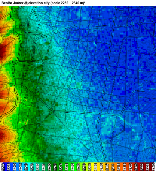
Below is the Elevation map of Benito Juárez, which displays elevation range with different colors. Scale of the first map is from 2232 to 2340 m (7323 to 7677 ft) with average elevation of 2254.6 meters (=7397 ft) [note 1]
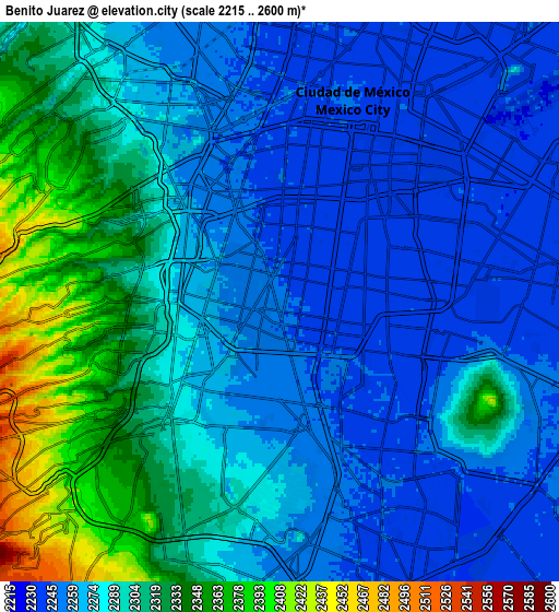
These maps also provides idea of topography and contour of this city, they are displayed at different zoom levels. More info about maps, scale and edge coordinates you can find below images.
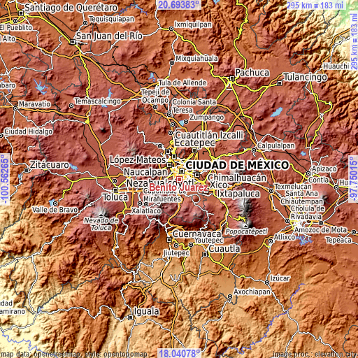
| \ | Map #1 | Map #2 | Topo.Map |
| Scale [m] | 2232..2340 m | 2215..2600 m | × |
| Scale [ft] | 7323..7677 ft | 7267..8530 ft | × |
| Average | 2254.6 m = 7397 ft | 2286.6 m = 7502 ft | × |
| Width | 9.22 km = 5.7 mi | 18.44 km = 11.5 mi | 295 km = 183.3 mi |
| Height | 9.22 km = 5.7 mi | 18.44 km = 11.5 mi | 295 km = 183.3 mi |
| ↑Max Latitude | 19.414152° | 19.455593° | 20.69383° |
| Latitude at center | 19.3727° | 19.3727° | 19.3727° |
| ↓Min Latitude | 19.331238° | 19.289765° | 18.04078° |
| ← Min Longitude | -99.200345° | -99.244291° | -100.56265° |
| Longitude center | -99.1564° | -99.1564° | -99.1564° |
| →Max Longitude | -99.112455° | -99.068509° | -97.75015° |
Nearby cities:
Cities around Benito Juárez sort by population:
• Mexico City elevation 2240 m
6.9 km,  25°
25°
• Álvaro Obregón 2338 m
5.2 km,  252°
252°
• Coyoacán 2255 m
2.9 km,  190°
190°
• Tlalpan 2256 m
8.6 km,  183°
183°
• Cuauhtémoc 2237 m
8.1 km,  7°
7°
• Iztacalco 2239 m
6.6 km,  67°
67°
• Miguel Hidalgo 2267 m
8.2 km,  326°
326°
• Benito Juarez 2243 m
2.9 km,  357°
357°
• Colonia del Valle 2247 m
1.6 km,  338°
338°
• Magdalena Contreras 2348 m
7.3 km,  231°
231°
• Colonia Nativitas 2239 m
2.3 km, 65°
• Polanco 2264 m
8.1 km, 326°
Multilingual:
 En español:
Benito Juárez elevación 2258 m.
 En France:
Benito Juárez élévation 2258 m.
 Auf Deutsch:
Benito Juárez höhe über dem Meeresspiegel ist 2258 m.

Sources and notes:
- [note 1] Map square and city borders are not equal. Map elevation data is calculated only from area inside that square.
- [src 1] Elevation data from geonames database provided with same terms of usage.
- [src 2] The elevation map of Benito Juárez is generated using elevation data from NASA's 3 arcsec (90m) resolution SRTM data.
- [src 3] Base (background) map © OpenStreetMap contributors tiles are generated by Geofabrik and OpenTopoMap.
Copyright & License:
This Benito Juárez Elevation Map is licensed under CC BY-SA. You may reuse any part from this page, if you give a proper credit by linking to this URL:
 More info on terms of use page.