Azcapotzalco elevation
Azcapotzalco (Mexico City), Mexico elevation is 2249 meters and Azcapotzalco elevation in feet is 7379 ft above sea level [src 1]. Azcapotzalco is a populated place (feature code) with elevation that is 935 meters (3068 ft) bigger than average city elevation in Mexico.
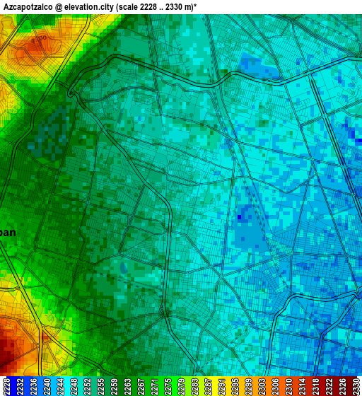
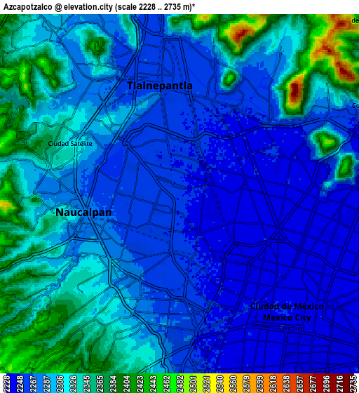
Below is the Elevation map of Azcapotzalco, which displays elevation range with different colors. Scale of the first map is from 2228 to 2330 m (7310 to 7644 ft) with average elevation of 2255.1 meters (=7399 ft) [note 1]
These maps also provides idea of topography and contour of this city, they are displayed at different zoom levels. More info about maps, scale and edge coordinates you can find below images.
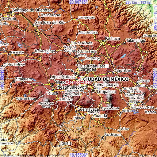
| \ | Map #1 | Map #2 | Topo.Map |
| Scale [m] | 2228..2330 m | 2228..2735 m | × |
| Scale [ft] | 7310..7644 ft | 7310..8973 ft | × |
| Average | 2255.1 m = 7399 ft | 2296.8 m = 7535 ft | × |
| Width | 9.21 km = 5.7 mi | 18.43 km = 11.5 mi | 294.8 km = 183.2 mi |
| Height | 9.21 km = 5.7 mi | 18.43 km = 11.5 mi | 294.8 km = 183.2 mi |
| ↑Max Latitude | 19.528403° | 19.569815° | 20.80715° |
| Latitude at center | 19.48698° | 19.48698° | 19.48698° |
| ↓Min Latitude | 19.445547° | 19.404103° | 18.15596° |
| ← Min Longitude | -99.229885° | -99.273831° | -100.59219° |
| Longitude center | -99.18594° | -99.18594° | -99.18594° |
| →Max Longitude | -99.141995° | -99.098049° | -97.77969° |
Nearby cities:
Cities around Azcapotzalco sort by population:
• Mexico City elevation 2240 m
8.9 km,  136°
136°
• Gustavo Adolfo Madero 2284 m
7.9 km,  84°
84°
• Naucalpan de Juárez 2300 m
5.7 km,  260°
260°
• Tlalnepantla 2260 m
6 km,  350°
350°
• Cuauhtémoc 2237 m
6.3 km, 138°
• Venustiano Carranza 2235 m
9.8 km,  119°
119°
• Miguel Hidalgo 2267 m
6.1 km,  194°
194°
• Benito Juarez 2243 m
10.3 km,  163°
163°
• Colonia Lindavista 2242 m
6.4 km,  85°
85°
• Polanco 2264 m
6.1 km, 193°
• Vista Hermosa 2296 m
5.1 km,  309°
309°
• Ejido del Tejocote 2501 m
9.7 km,  268°
268°
Multilingual:
 En español:
Azcapotzalco elevación 2249 m.
 En France:
Azcapotzalco élévation 2249 m.
 Auf Deutsch:
Azcapotzalco höhe über dem Meeresspiegel ist 2249 m.

Sources and notes:
- [note 1] Map square and city borders are not equal. Map elevation data is calculated only from area inside that square.
- [src 1] Elevation data from geonames database provided with same terms of usage.
- [src 2] The elevation map of Azcapotzalco is generated using elevation data from NASA's 3 arcsec (90m) resolution SRTM data.
- [src 3] Base (background) map © OpenStreetMap contributors tiles are generated by Geofabrik and OpenTopoMap.
Copyright & License:
This Azcapotzalco Elevation Map is licensed under CC BY-SA. You may reuse any part from this page, if you give a proper credit by linking to this URL:
 More info on terms of use page.