Tlalnepantla elevation
Tlalnepantla (State of Mexico, Tlalnepantla de Baz), Mexico elevation is 2260 meters and Tlalnepantla elevation in feet is 7415 ft above sea level [src 1]. Tlalnepantla is a populated place (feature code) with elevation that is 946 meters (3104 ft) bigger than average city elevation in Mexico.
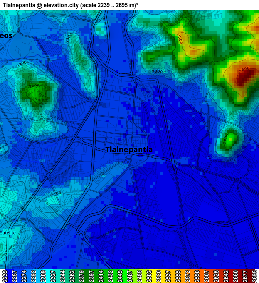
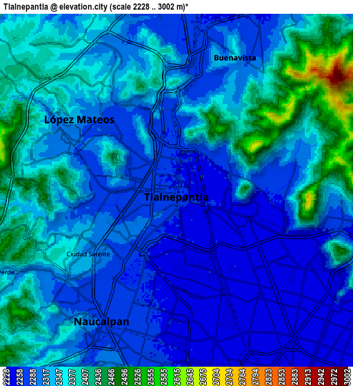
Below is the Elevation map of Tlalnepantla, which displays elevation range with different colors. Scale of the first map is from 2239 to 2695 m (7346 to 8842 ft) with average elevation of 2291.3 meters (=7517 ft) [note 1]
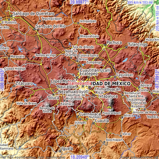
These maps also provides idea of topography and contour of this city, they are displayed at different zoom levels. More info about maps, scale and edge coordinates you can find below images.
| \ | Map #1 | Map #2 | Topo.Map |
| Scale [m] | 2239..2695 m | 2228..3002 m | × |
| Scale [ft] | 7346..8842 ft | 7310..9849 ft | × |
| Average | 2291.3 m = 7517 ft | 2329.4 m = 7642 ft | × |
| Width | 9.21 km = 5.7 mi | 18.42 km = 11.4 mi | 294.7 km = 183.1 mi |
| Height | 9.21 km = 5.7 mi | 18.42 km = 11.4 mi | 294.7 km = 183.1 mi |
| ↑Max Latitude | 19.581459° | 19.622858° | 20.85977° |
| Latitude at center | 19.54005° | 19.54005° | 19.54005° |
| ↓Min Latitude | 19.49863° | 19.4572° | 18.20945° |
| ← Min Longitude | -99.239325° | -99.283271° | -100.60163° |
| Longitude center | -99.19538° | -99.19538° | -99.19538° |
| →Max Longitude | -99.151435° | -99.107489° | -97.78913° |
Nearby cities:
Cities around Tlalnepantla sort by population:
• Gustavo Adolfo Madero elevation 2284 m
10.2 km,  120°
120°
• Naucalpan de Juárez 2300 m
8.3 km,  214°
214°
• Ciudad López Mateos 2345 m
6.7 km,  287°
287°
• Azcapotzalco 2249 m
6 km,  170°
170°
• Buenavista 2333 m
8.1 km,  19°
19°
• Colonia Lindavista 2242 m
9.2 km,  126°
126°
• Ampliación San Mateo (Colonia Solidaridad) 2275 m
9.9 km,  30°
30°
• Puerto Escondido (Tepeolulco Puerto Escondido) 2346 m
10.3 km,  82°
82°
• Vista Hermosa 2296 m
4 km,  227°
227°
• Colonia Lázaro Cárdenas (Los Hornos) 2251 m
11.1 km, 23°
• Sierra de Guadalupe 2345 m
6.9 km, 32°
• Ejido del Tejocote 2501 m
10.7 km, 234°
Multilingual:
 En español:
Tlanepantla de baz, Tlalnepantla de baz elevación 2260 m.
 En France:
Tlalnepantla élévation 2260 m.
 Auf Deutsch:
Tlalnepantla höhe über dem Meeresspiegel ist 2260 m.

Sources and notes:
- [note 1] Map square and city borders are not equal. Map elevation data is calculated only from area inside that square.
- [src 1] Elevation data from geonames database provided with same terms of usage.
- [src 2] The elevation map of Tlalnepantla is generated using elevation data from NASA's 3 arcsec (90m) resolution SRTM data.
- [src 3] Base (background) map © OpenStreetMap contributors tiles are generated by Geofabrik and OpenTopoMap.
Copyright & License:
This Tlalnepantla Elevation Map is licensed under CC BY-SA. You may reuse any part from this page, if you give a proper credit by linking to this URL:
 More info on terms of use page.