Ciudad López Mateos elevation
Ciudad López Mateos (State of Mexico, Atizapán de Zaragoza), Mexico elevation is 2345 meters and Ciudad López Mateos elevation in feet is 7694 ft above sea level [src 1]. Ciudad López Mateos is a seat of a second-order administrative division (feature code) with elevation that is 1031 meters (3383 ft) bigger than average city elevation in Mexico.
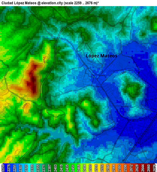
Below is the Elevation map of Ciudad López Mateos, which displays elevation range with different colors. Scale of the first map is from 2259 to 2676 m (7411 to 8780 ft) with average elevation of 2369.5 meters (=7774 ft) [note 1]
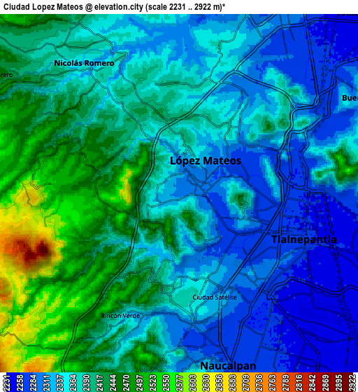
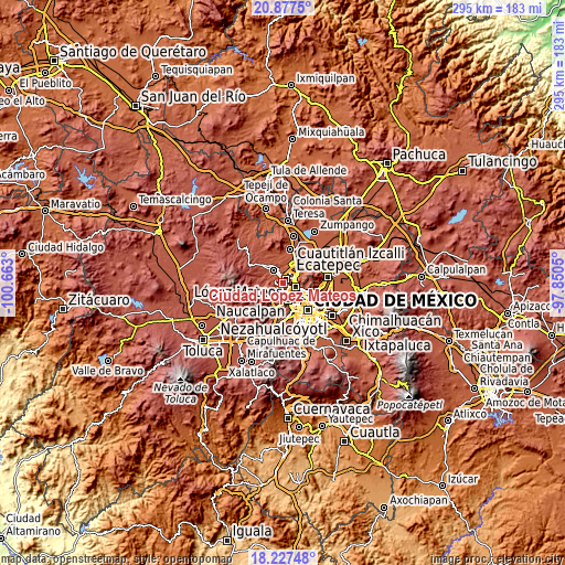
These maps also provides idea of topography and contour of this city, they are displayed at different zoom levels. More info about maps, scale and edge coordinates you can find below images.
| \ | Map #1 | Map #2 | Topo.Map |
| Scale [m] | 2259..2676 m | 2231..2922 m | × |
| Scale [ft] | 7411..8780 ft | 7320..9587 ft | × |
| Average | 2369.5 m = 7774 ft | 2378.3 m = 7803 ft | × |
| Width | 9.21 km = 5.7 mi | 18.42 km = 11.4 mi | 294.7 km = 183.1 mi |
| Height | 9.21 km = 5.7 mi | 18.42 km = 11.4 mi | 294.7 km = 183.1 mi |
| ↑Max Latitude | 19.599335° | 19.640728° | 20.8775° |
| Latitude at center | 19.55793° | 19.55793° | 19.55793° |
| ↓Min Latitude | 19.516515° | 19.475089° | 18.22748° |
| ← Min Longitude | -99.300695° | -99.344641° | -100.663° |
| Longitude center | -99.25675° | -99.25675° | -99.25675° |
| →Max Longitude | -99.212805° | -99.168859° | -97.8505° |
Nearby cities:
Cities around Ciudad López Mateos sort by population:
• Naucalpan de Juárez elevation 2300 m
9 km,  168°
168°
• Tlalnepantla 2260 m
6.7 km,  107°
107°
• Cuautitlán Izcalli 2288 m
10.5 km,  24°
24°
• Azcapotzalco 2249 m
10.8 km,  136°
136°
• Nicolás Romero 2404 m
10.7 km,  330°
330°
• Buenavista 2333 m
10.7 km,  58°
58°
• Vista Hermosa 2296 m
5.8 km, 142°
• San Miguel Hila 2418 m
8.2 km,  298°
298°
• Sierra de Guadalupe 2345 m
10.9 km,  69°
69°
• Ejido del Tejocote 2501 m
8.5 km,  195°
195°
• Ejido de Guadalupe 2360 m
9 km,  349°
349°
• Rincón Verde 2366 m
7.7 km,  207°
207°
Multilingual:
 En español:
Adolfo López Mateos elevación 2345 m.
 En France:
Ciudad López Mateos élévation 2345 m.
 Auf Deutsch:
Ciudad López Mateos höhe über dem Meeresspiegel ist 2345 m.
 На русском:
Сьюдад-Лопес-Матеус высота над уровнем моря 2345 м
Sources and notes:
- [note 1] Map square and city borders are not equal. Map elevation data is calculated only from area inside that square.
- [src 1] Elevation data from geonames database provided with same terms of usage.
- [src 2] The elevation map of Ciudad López Mateos is generated using elevation data from NASA's 3 arcsec (90m) resolution SRTM data.
- [src 3] Base (background) map © OpenStreetMap contributors tiles are generated by Geofabrik and OpenTopoMap.
Copyright & License:
This Ciudad López Mateos Elevation Map is licensed under CC BY-SA. You may reuse any part from this page, if you give a proper credit by linking to this URL:
 More info on terms of use page.