Tórshavn elevation
Tórshavn (Streymoy), Faroe Islands elevation is 1 meters and Tórshavn elevation in feet is 3 ft above sea level [src 1]. Tórshavn is a capital of a political entity (feature code) with elevation that is 91 meters (299 ft) smaller than average city elevation in Faroe Islands.
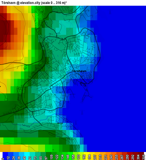
Below is the Elevation map of Tórshavn, which displays elevation range with different colors. Scale of the first map is from 0 to 316 m (0 to 1037 ft) with average elevation of 64.1 meters (=210 ft) [note 1]
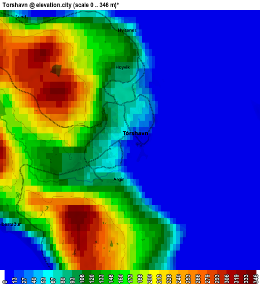
These maps also provides idea of topography and contour of this city, they are displayed at different zoom levels. More info about maps, scale and edge coordinates you can find below images.
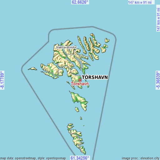
| \ | Map #1 | Map #2 | Topo.Map |
| Scale [m] | 0..316 m | 0..346 m | × |
| Scale [ft] | 0..1037 ft | 0..1135 ft | × |
| Average | 64.1 m = 210 ft | 95.6 m = 314 ft | × |
| Width | 4.59 km = 2.9 mi | 9.17 km = 5.7 mi | 146.8 km = 91.2 mi |
| Height | 4.59 km = 2.9 mi | 9.17 km = 5.7 mi | 146.8 km = 91.2 mi |
| ↑Max Latitude | 62.030348° | 62.050951° | 62.6626° |
| Latitude at center | 62.00973° | 62.00973° | 62.00973° |
| ↓Min Latitude | 61.989099° | 61.968453° | 61.34256° |
| ← Min Longitude | -6.815585° | -6.859531° | -8.17789° |
| Longitude center | -6.77164° | -6.77164° | -6.77164° |
| →Max Longitude | -6.727695° | -6.683749° | -5.36539° |
Nearby cities:
Cities around Tórshavn sort by population:
• Klaksvík elevation 88 m
25.9 km,  21°
21°
• Hoyvík 76 m
2.8 km,  349°
349°
• Argir 75 m
1.5 km,  179°
179°
• Fuglafjørður 30 m
26.1 km,  355°
355°
• Vestmanna 142 m
26.3 km,  307°
307°
• Kollafjørður 31 m
13.5 km,  327°
327°
• Miðvágur 105 m
22.5 km,  281°
281°
• Sandavágur 38 m
20.3 km, 283°
• Sandur 113 m
18.7 km,  185°
185°
• Skopun 68 m
13.2 km,  205°
205°
• Skálavík 12 m
20.6 km,  163°
163°
• Eystur 291 m
22.2 km,  2°
2°
Multilingual:
 En español:
Tórshavn elevación 1 m.
 En France:
Tórshavn élévation 1 m.


Sources and notes:
- [note 1] Map square and city borders are not equal. Map elevation data is calculated only from area inside that square.
- [src 1] Elevation data from geonames database provided with same terms of usage.
- [src 2] The elevation map of Tórshavn is generated using GMTED2010 database with 7.5 arcsec (225m) resolution.
- [src 3] Base (background) map © OpenStreetMap contributors tiles are generated by Geofabrik and OpenTopoMap.
Copyright & License:
This Tórshavn Elevation Map is licensed under CC BY-SA. You may reuse any part from this page, if you give a proper credit by linking to this URL:
 More info on terms of use page.