Bogotá elevation
Bogotá (Bogota D.C., Bogotá D.C.), Colombia elevation is 2582 meters and Bogotá elevation in feet is 8471 ft above sea level [src 1]. Bogotá is a capital of a political entity (feature code) with elevation that is 1433 meters (4701 ft) bigger than average city elevation in Colombia.
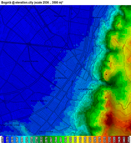
Below is the Elevation map of Bogotá, which displays elevation range with different colors. Scale of the first map is from 2536 to 3500 m (8320 to 11483 ft) with average elevation of 2700 meters (=8858 ft) [note 1]
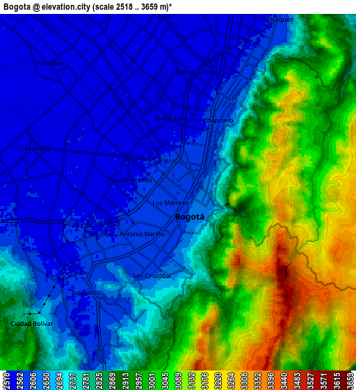
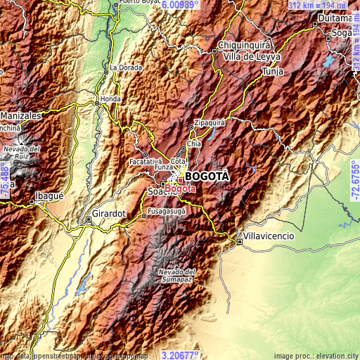
These maps also provides idea of topography and contour of this city, they are displayed at different zoom levels. More info about maps, scale and edge coordinates you can find below images.
| \ | Map #1 | Map #2 | Topo.Map |
| Scale [m] | 2536..3500 m | 2518..3659 m | × |
| Scale [ft] | 8320..11483 ft | 8261..12005 ft | × |
| Average | 2700 m = 8858 ft | 2798 m = 9180 ft | × |
| Width | 9.74 km = 6.1 mi | 19.48 km = 12.1 mi | 311.7 km = 193.7 mi |
| Height | 9.74 km = 6.1 mi | 19.48 km = 12.1 mi | 311.7 km = 193.7 mi |
| ↑Max Latitude | 4.653512° | 4.697311° | 6.00989° |
| Latitude at center | 4.60971° | 4.60971° | 4.60971° |
| ↓Min Latitude | 4.565905° | 4.522098° | 3.20677° |
| ← Min Longitude | -74.125695° | -74.169641° | -75.488° |
| Longitude center | -74.08175° | -74.08175° | -74.08175° |
| →Max Longitude | -74.037805° | -73.993859° | -72.6755° |
Nearby cities:
Cities around Bogotá sort by population:
• Soacha elevation 2565 m
15.3 km,  257°
257°
• Funza 2548 m
18.7 km,  309°
309°
• Madrid 2547 m
24.4 km,  304°
304°
• Mosquera 2544 m
19.6 km, 303°
• Sibaté 2684 m
23.7 km,  236°
236°
• La Calera 2690 m
17.5 km,  45°
45°
• Cota 2557 m
22.3 km,  355°
355°
• Choachí 1921 m
19.8 km,  116°
116°
• Une 2371 m
23.8 km,  164°
164°
• Chipaque 2438 m
19.1 km,  167°
167°
• Barrio San Luis 3047 m
9.3 km, 45°
• Ubaque 1906 m
21 km,  130°
130°
Multilingual:
 En español:
Santafé de Bogotá elevación 2582 m.
 En France:
Bogota élévation 2582 m.


Sources and notes:
- [note 1] Map square and city borders are not equal. Map elevation data is calculated only from area inside that square.
- [src 1] Elevation data from geonames database provided with same terms of usage.
- [src 2] The elevation map of Bogotá is generated using elevation data from NASA's 3 arcsec (90m) resolution SRTM data.
- [src 3] Base (background) map © OpenStreetMap contributors tiles are generated by Geofabrik and OpenTopoMap.
Copyright & License:
This Bogotá Elevation Map is licensed under CC BY-SA. You may reuse any part from this page, if you give a proper credit by linking to this URL:
 More info on terms of use page.