Madrid elevation
Madrid (Cundinamarca), Colombia elevation is 2547 meters and Madrid elevation in feet is 8356 ft above sea level [src 1]. Madrid is a seat of a second-order administrative division (feature code) with elevation that is 1398 meters (4587 ft) bigger than average city elevation in Colombia.
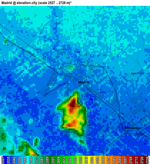
Below is the Elevation map of Madrid, which displays elevation range with different colors. Scale of the first map is from 2527 to 2728 m (8291 to 8950 ft) with average elevation of 2554.8 meters (=8382 ft) [note 1]
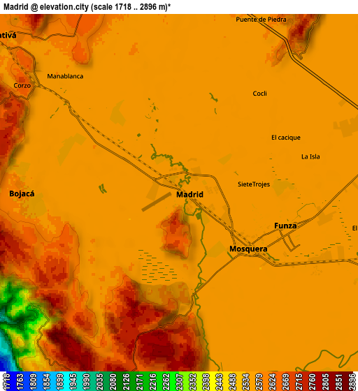
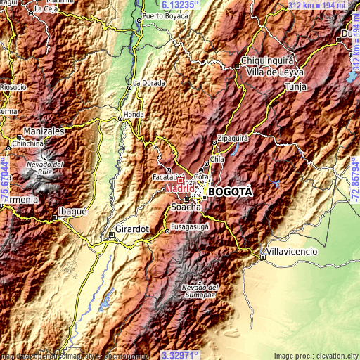
These maps also provides idea of topography and contour of this city, they are displayed at different zoom levels. More info about maps, scale and edge coordinates you can find below images.
| \ | Map #1 | Map #2 | Topo.Map |
| Scale [m] | 2527..2728 m | 1718..2896 m | × |
| Scale [ft] | 8291..8950 ft | 5636..9501 ft | × |
| Average | 2554.8 m = 8382 ft | 2568.4 m = 8427 ft | × |
| Width | 9.74 km = 6.1 mi | 19.48 km = 12.1 mi | 311.6 km = 193.6 mi |
| Height | 9.74 km = 6.1 mi | 19.48 km = 12.1 mi | 311.7 km = 193.7 mi |
| ↑Max Latitude | 4.776244° | 4.820035° | 6.13235° |
| Latitude at center | 4.73245° | 4.73245° | 4.73245° |
| ↓Min Latitude | 4.688653° | 4.644854° | 3.32971° |
| ← Min Longitude | -74.308135° | -74.352081° | -75.67044° |
| Longitude center | -74.26419° | -74.26419° | -74.26419° |
| →Max Longitude | -74.220245° | -74.176299° | -72.85794° |
Nearby cities:
Cities around Madrid sort by population:
• Soacha elevation 2565 m
17.8 km,  162°
162°
• Facatativá 2589 m
13.5 km,  312°
312°
• Funza 2548 m
6.1 km,  107°
107°
• Mosquera 2544 m
4.8 km,  128°
128°
• Cota 2557 m
20.3 km,  65°
65°
• El Rosal 2612 m
13.4 km,  2°
2°
• Bojacá 2583 m
8.5 km,  269°
269°
• Tenjo 2580 m
20.5 km,  40°
40°
• Zipacón 2542 m
13.2 km,  282°
282°
• San Antonio del Tequendama 1541 m
16.2 km,  216°
216°
• Tena 1430 m
16.3 km,  240°
240°
• Cachipay 1484 m
19.1 km, 269°
Multilingual:
 En español:
Madrid elevación 2547 m.
 En France:
Madrid élévation 2547 m.


Sources and notes:
- [note 1] Map square and city borders are not equal. Map elevation data is calculated only from area inside that square.
- [src 1] Elevation data from geonames database provided with same terms of usage.
- [src 2] The elevation map of Madrid is generated using elevation data from NASA's 3 arcsec (90m) resolution SRTM data.
- [src 3] Base (background) map © OpenStreetMap contributors tiles are generated by Geofabrik and OpenTopoMap.
Copyright & License:
This Madrid Elevation Map is licensed under CC BY-SA. You may reuse any part from this page, if you give a proper credit by linking to this URL:
 More info on terms of use page.