Facatativá elevation
Facatativá (Cundinamarca), Colombia elevation is 2589 meters and Facatativá elevation in feet is 8494 ft above sea level [src 1]. Facatativá is a seat of a second-order administrative division (feature code) with elevation that is 1440 meters (4724 ft) bigger than average city elevation in Colombia.
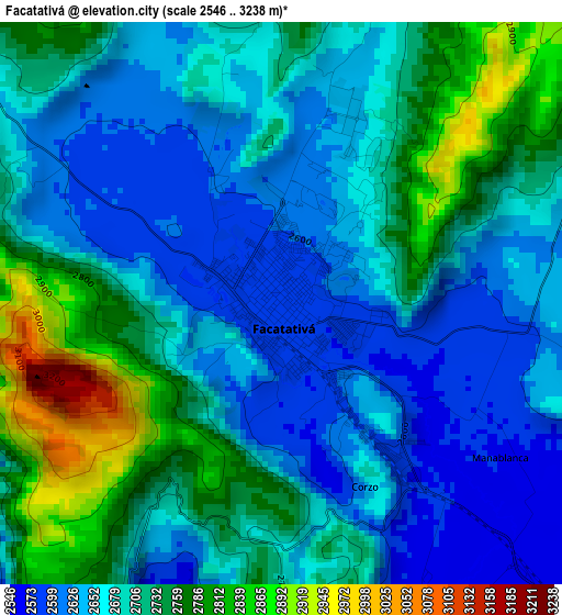
Below is the Elevation map of Facatativá, which displays elevation range with different colors. Scale of the first map is from 2546 to 3238 m (8353 to 10623 ft) with average elevation of 2693.3 meters (=8836 ft) [note 1]
These maps also provides idea of topography and contour of this city, they are displayed at different zoom levels. More info about maps, scale and edge coordinates you can find below images.
| \ | Map #1 | Map #2 | Topo.Map |
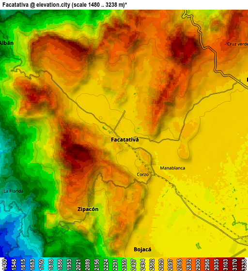
| Scale [m] | 2546..3238 m | 1480..3238 m | × |
| Scale [ft] | 8353..10623 ft | 4856..10623 ft | × |
| Average | 2693.3 m = 8836 ft | 2571.3 m = 8436 ft | × |
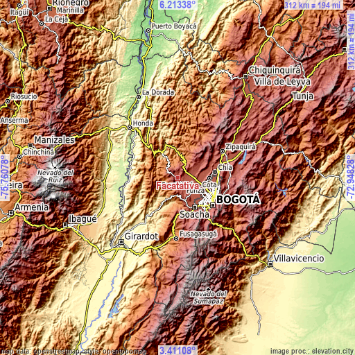
| Width | 9.74 km = 6.1 mi | 19.48 km = 12.1 mi | 311.6 km = 193.6 mi |
| Height | 9.74 km = 6.1 mi | 19.48 km = 12.1 mi | 311.6 km = 193.6 mi |
| ↑Max Latitude | 4.857459° | 4.901245° | 6.21338° |
| Latitude at center | 4.81367° | 4.81367° | 4.81367° |
| ↓Min Latitude | 4.769878° | 4.726084° | 3.41108° |
| ← Min Longitude | -74.398475° | -74.442421° | -75.76078° |
| Longitude center | -74.35453° | -74.35453° | -74.35453° |
| →Max Longitude | -74.310585° | -74.266639° | -72.94828° |
Nearby cities:
Cities around Facatativá sort by population:
• Funza elevation 2548 m
19.1 km,  124°
124°
• Madrid 2547 m
13.5 km,  132°
132°
• Mosquera 2544 m
18.3 km, 131°
• Anolaima 1577 m
16.2 km,  277°
277°
• El Rosal 2612 m
11.4 km,  67°
67°
• Bojacá 2583 m
9.2 km,  170°
170°
• Sasaima 1141 m
19.2 km,  332°
332°
• Albán 2242 m
11.6 km,  307°
307°
• Zipacón 2542 m
6.7 km,  204°
204°
• Guayabal de Síquima 1604 m
14.4 km,  299°
299°
• Tena 1430 m
17.6 km,  193°
193°
• Cachipay 1484 m
13 km,  224°
224°
Multilingual:
 En español:
Facatativá elevación 2589 m.
 En France:
Facatativá élévation 2589 m.
 Auf Deutsch:
Facatativá höhe über dem Meeresspiegel ist 2589 m.

Sources and notes:
- [note 1] Map square and city borders are not equal. Map elevation data is calculated only from area inside that square.
- [src 1] Elevation data from geonames database provided with same terms of usage.
- [src 2] The elevation map of Facatativá is generated using elevation data from NASA's 3 arcsec (90m) resolution SRTM data.
- [src 3] Base (background) map © OpenStreetMap contributors tiles are generated by Geofabrik and OpenTopoMap.
Copyright & License:
This Facatativá Elevation Map is licensed under CC BY-SA. You may reuse any part from this page, if you give a proper credit by linking to this URL:
 More info on terms of use page.