Anolaima elevation
Anolaima (Cundinamarca, Guayabal de Siquima), Colombia elevation is 1577 meters and Anolaima elevation in feet is 5174 ft above sea level [src 1]. Anolaima is a populated place (feature code) with elevation that is 428 meters (1404 ft) bigger than average city elevation in Colombia.
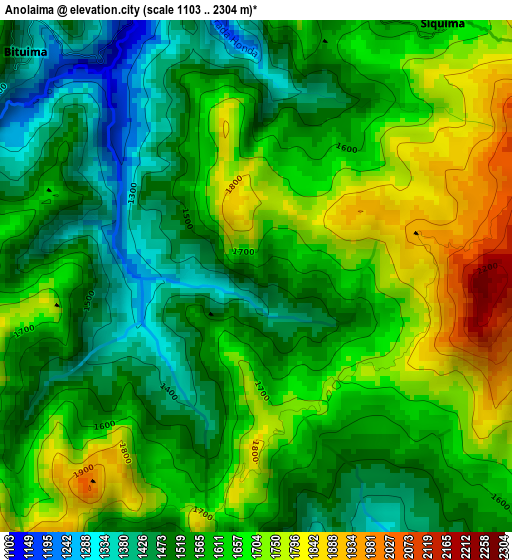
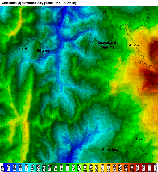
Below is the Elevation map of Anolaima, which displays elevation range with different colors. Scale of the first map is from 1103 to 2304 m (3619 to 7559 ft) with average elevation of 1601.5 meters (=5254 ft) [note 1]
These maps also provides idea of topography and contour of this city, they are displayed at different zoom levels. More info about maps, scale and edge coordinates you can find below images.
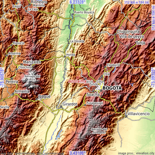
| \ | Map #1 | Map #2 | Topo.Map |
| Scale [m] | 1103..2304 m | 967..3086 m | × |
| Scale [ft] | 3619..7559 ft | 3173..10125 ft | × |
| Average | 1601.5 m = 5254 ft | 1737 m = 5699 ft | × |
| Width | 9.74 km = 6.1 mi | 19.48 km = 12.1 mi | 311.6 km = 193.6 mi |
| Height | 9.74 km = 6.1 mi | 19.48 km = 12.1 mi | 311.6 km = 193.6 mi |
| ↑Max Latitude | 4.877408° | 4.921192° | 6.23328° |
| Latitude at center | 4.83362° | 4.83362° | 4.83362° |
| ↓Min Latitude | 4.78983° | 4.746036° | 3.43106° |
| ← Min Longitude | -74.543445° | -74.587391° | -75.90575° |
| Longitude center | -74.4995° | -74.4995° | -74.4995° |
| →Max Longitude | -74.455555° | -74.411609° | -73.09325° |
Nearby cities:
Cities around Anolaima sort by population:
• Facatativá elevation 2589 m
16.2 km,  97°
97°
• Villeta 810 m
19.7 km,  8°
8°
• Sasaima 1141 m
16.5 km,  25°
25°
• Quipile 1321 m
10.5 km,  201°
201°
• Albán 2242 m
8.4 km,  55°
55°
• Vianí 1491 m
8.3 km,  302°
302°
• Zipacón 2542 m
15.6 km,  122°
122°
• Chaguaní 1030 m
16.5 km,  320°
320°
• Guayabal de Síquima 1604 m
6 km,  36°
36°
• Bituima 1364 m
6.2 km,  314°
314°
• San Juan de Rioseco 1277 m
13.6 km,  276°
276°
• Cachipay 1484 m
13.4 km,  148°
148°
Multilingual:
 En español:
Anolaima elevación 1577 m.
 En France:
Anolaima élévation 1577 m.
 Auf Deutsch:
Anolaima höhe über dem Meeresspiegel ist 1577 m.

Sources and notes:
- [note 1] Map square and city borders are not equal. Map elevation data is calculated only from area inside that square.
- [src 1] Elevation data from geonames database provided with same terms of usage.
- [src 2] The elevation map of Anolaima is generated using elevation data from NASA's 3 arcsec (90m) resolution SRTM data.
- [src 3] Base (background) map © OpenStreetMap contributors tiles are generated by Geofabrik and OpenTopoMap.
Copyright & License:
This Anolaima Elevation Map is licensed under CC BY-SA. You may reuse any part from this page, if you give a proper credit by linking to this URL:
 More info on terms of use page.