Choachí elevation
Choachí (Cundinamarca), Colombia elevation is 1921 meters and Choachí elevation in feet is 6302 ft above sea level [src 1]. Choachí is a seat of a second-order administrative division (feature code) with elevation that is 772 meters (2533 ft) bigger than average city elevation in Colombia.
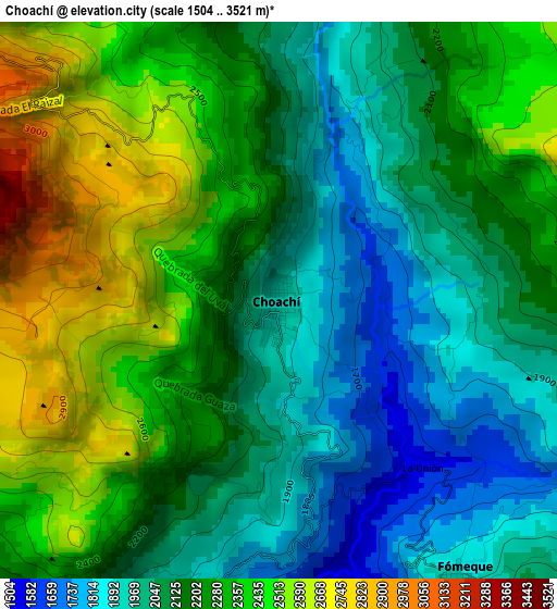
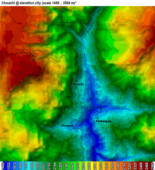
Below is the Elevation map of Choachí, which displays elevation range with different colors. Scale of the first map is from 1504 to 3521 m (4934 to 11552 ft) with average elevation of 2202 meters (=7224 ft) [note 1]
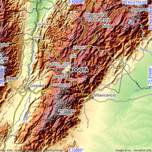
These maps also provides idea of topography and contour of this city, they are displayed at different zoom levels. More info about maps, scale and edge coordinates you can find below images.
| \ | Map #1 | Map #2 | Topo.Map |
| Scale [m] | 1504..3521 m | 1450..3569 m | × |
| Scale [ft] | 4934..11552 ft | 4757..11709 ft | × |
| Average | 2202 m = 7224 ft | 2449.1 m = 8035 ft | × |
| Width | 9.74 km = 6.1 mi | 19.48 km = 12.1 mi | 311.7 km = 193.7 mi |
| Height | 9.74 km = 6.1 mi | 19.48 km = 12.1 mi | 311.7 km = 193.7 mi |
| ↑Max Latitude | 4.572777° | 4.616581° | 5.92933° |
| Latitude at center | 4.52897° | 4.52897° | 4.52897° |
| ↓Min Latitude | 4.485161° | 4.441349° | 3.12589° |
| ← Min Longitude | -73.966675° | -74.010621° | -75.32898° |
| Longitude center | -73.92273° | -73.92273° | -73.92273° |
| →Max Longitude | -73.878785° | -73.834839° | -72.51648° |
Nearby cities:
Cities around Choachí sort by population:
• Bogotá elevation 2582 m
19.8 km,  296°
296°
• La Calera 2690 m
21.9 km,  346°
346°
• Cáqueza 1696 m
14 km,  191°
191°
• Fómeque 1820 m
5.3 km,  148°
148°
• Une 2371 m
18 km,  219°
219°
• Chipaque 2438 m
16.5 km,  234°
234°
• Barrio San Luis 3047 m
18.9 km,  324°
324°
• Fosca 2112 m
21.2 km,  184°
184°
• Quetame 1585 m
22.9 km,  162°
162°
• Ubaque 1906 m
5 km,  199°
199°
• El Calvario 1902 m
30.5 km,  129°
129°
• San Juanito 2018 m
27.9 km,  105°
105°
Multilingual:
 En español:
Choachí elevación 1921 m.
 En France:
Choachí élévation 1921 m.
 Auf Deutsch:
Choachí höhe über dem Meeresspiegel ist 1921 m.

Sources and notes:
- [note 1] Map square and city borders are not equal. Map elevation data is calculated only from area inside that square.
- [src 1] Elevation data from geonames database provided with same terms of usage.
- [src 2] The elevation map of Choachí is generated using elevation data from NASA's 3 arcsec (90m) resolution SRTM data.
- [src 3] Base (background) map © OpenStreetMap contributors tiles are generated by Geofabrik and OpenTopoMap.
Copyright & License:
This Choachí Elevation Map is licensed under CC BY-SA. You may reuse any part from this page, if you give a proper credit by linking to this URL:
 More info on terms of use page.