Une elevation
Une (Cundinamarca), Colombia elevation is 2371 meters and Une elevation in feet is 7779 ft above sea level [src 1]. Une is a seat of a second-order administrative division (feature code) with elevation that is 1222 meters (4009 ft) bigger than average city elevation in Colombia.
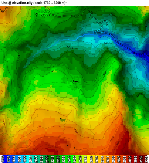
Below is the Elevation map of Une, which displays elevation range with different colors. Scale of the first map is from 1730 to 3209 m (5676 to 10528 ft) with average elevation of 2445.2 meters (=8022 ft) [note 1]
These maps also provides idea of topography and contour of this city, they are displayed at different zoom levels. More info about maps, scale and edge coordinates you can find below images.
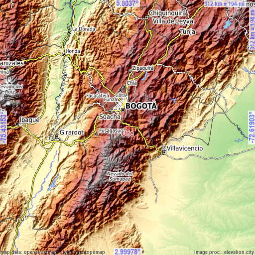
| \ | Map #1 | Topo.Map |
| Scale [m] | 1730..3209 m | × |
| Scale [ft] | 5676..10528 ft | × |
| Average | 2445.2 m = 8022 ft | × |
| Width | 9.74 km = 6.1 mi | 311.8 km = 193.7 mi |
| Height | 9.74 km = 6.1 mi | 311.8 km = 193.7 mi |
| ↑Max Latitude | 4.446874° | 5.8037° |
| Latitude at center | 4.40306° | 4.40306° |
| ↓Min Latitude | 4.359243° | 2.99978° |
| ← Min Longitude | -74.069225° | -75.43153° |
| Longitude center | -74.02528° | -74.02528° |
| →Max Longitude | -73.981335° | -72.61903° |
Nearby cities:
Cities around Une sort by population:
• Bogotá elevation 2582 m
23.8 km,  344°
344°
• Soacha 2565 m
28.9 km,  312°
312°
• Sibaté 2684 m
27.8 km,  290°
290°
• Cáqueza 1696 m
8.7 km,  88°
88°
• Fómeque 1820 m
17 km,  56°
56°
• Choachí 1921 m
18 km,  39°
39°
• Chipaque 2438 m
4.9 km,  334°
334°
• Barrio San Luis 3047 m
29.4 km,  0°
0°
• Fosca 2112 m
12 km,  126°
126°
• Quetame 1585 m
19.8 km,  113°
113°
• Ubaque 1906 m
13.5 km,  46°
46°
• Gutiérrez 2295 m
16.7 km,  171°
171°
Multilingual:
 En español:
Une elevación 2371 m.
 En France:
Une élévation 2371 m.


Sources and notes:
- [note 1] Map square and city borders are not equal. Map elevation data is calculated only from area inside that square.
- [src 1] Elevation data from geonames database provided with same terms of usage.
- [src 2] The elevation map of Une is generated using elevation data from NASA's 3 arcsec (90m) resolution SRTM data.
- [src 3] Base (background) map © OpenStreetMap contributors tiles are generated by Geofabrik and OpenTopoMap.
Copyright & License:
This Une Elevation Map is licensed under CC BY-SA. You may reuse any part from this page, if you give a proper credit by linking to this URL:
 More info on terms of use page.