San Juanito elevation
San Juanito (Meta), Colombia elevation is 2018 meters and San Juanito elevation in feet is 6621 ft above sea level [src 1]. San Juanito is a seat of a second-order administrative division (feature code) with elevation that is 869 meters (2851 ft) bigger than average city elevation in Colombia.
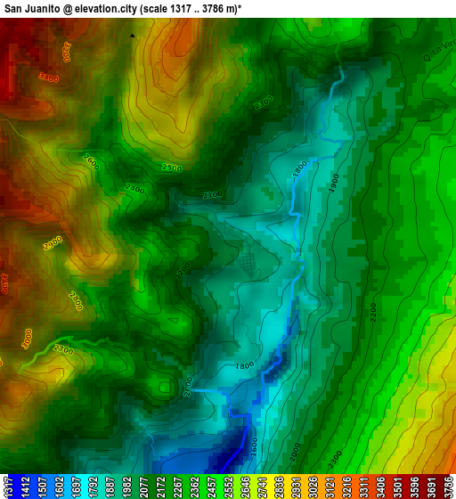
Below is the Elevation map of San Juanito, which displays elevation range with different colors. Scale of the first map is from 1317 to 3786 m (4321 to 12421 ft) with average elevation of 2371 meters (=7779 ft) [note 1]
These maps also provides idea of topography and contour of this city, they are displayed at different zoom levels. More info about maps, scale and edge coordinates you can find below images.
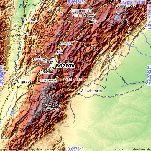
| \ | Map #1 | Topo.Map |
| Scale [m] | 1317..3786 m | × |
| Scale [ft] | 4321..12421 ft | × |
| Average | 2371 m = 7779 ft | × |
| Width | 9.74 km = 6.1 mi | 311.7 km = 193.7 mi |
| Height | 9.74 km = 6.1 mi | 311.8 km = 193.7 mi |
| ↑Max Latitude | 4.504841° | 5.86154° |
| Latitude at center | 4.46103° | 4.46103° |
| ↓Min Latitude | 4.417217° | 3.05784° |
| ← Min Longitude | -73.724425° | -75.08673° |
| Longitude center | -73.68048° | -73.68048° |
| →Max Longitude | -73.636535° | -72.27423° |
Nearby cities:
Cities around San Juanito sort by population:
• Cumaral elevation 412 m
30.1 km,  134°
134°
• Cáqueza 1696 m
30.2 km,  258°
258°
• Restrepo 474 m
26.1 km,  149°
149°
• Fómeque 1820 m
24.2 km,  277°
277°
• Choachí 1921 m
27.9 km,  285°
285°
• Guayabetal 1087 m
31.3 km,  208°
208°
• Gachalá 1729 m
31.3 km,  34°
34°
• Fosca 2112 m
31.7 km,  244°
244°
• Quetame 1585 m
24.6 km,  234°
234°
• Ubaque 1906 m
28.6 km, 275°
• Gama 2171 m
34.4 km,  12°
12°
• El Calvario 1902 m
12.4 km,  196°
196°
Multilingual:
 En español:
San Juanito elevación 2018 m.
 En France:
San Juanito élévation 2018 m.
 Auf Deutsch:
San Juanito höhe über dem Meeresspiegel ist 2018 m.

Sources and notes:
- [note 1] Map square and city borders are not equal. Map elevation data is calculated only from area inside that square.
- [src 1] Elevation data from geonames database provided with same terms of usage.
- [src 2] The elevation map of San Juanito is generated using elevation data from NASA's 3 arcsec (90m) resolution SRTM data.
- [src 3] Base (background) map © OpenStreetMap contributors tiles are generated by Geofabrik and OpenTopoMap.
Copyright & License:
This San Juanito Elevation Map is licensed under CC BY-SA. You may reuse any part from this page, if you give a proper credit by linking to this URL:
 More info on terms of use page.