Cumaral elevation
Cumaral (Meta), Colombia elevation is 412 meters and Cumaral elevation in feet is 1352 ft above sea level [src 1]. Cumaral is a seat of a second-order administrative division (feature code) with elevation that is 737 meters (2418 ft) smaller than average city elevation in Colombia.
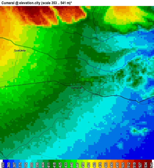
Below is the Elevation map of Cumaral, which displays elevation range with different colors. Scale of the first map is from 353 to 541 m (1158 to 1775 ft) with average elevation of 413 meters (=1355 ft) [note 1]
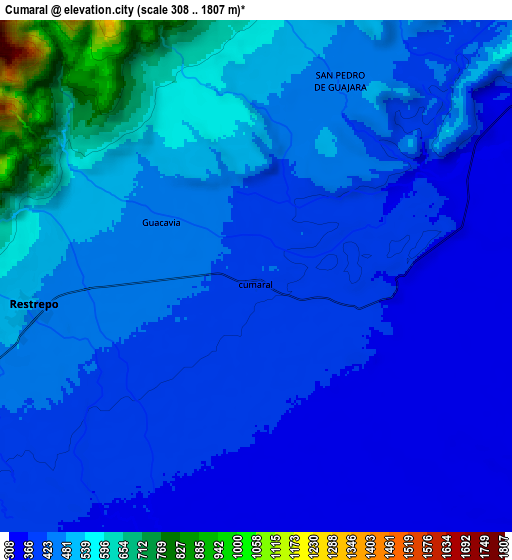
These maps also provides idea of topography and contour of this city, they are displayed at different zoom levels. More info about maps, scale and edge coordinates you can find below images.
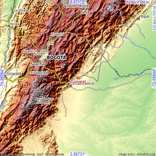
| \ | Map #1 | Map #2 | Topo.Map |
| Scale [m] | 353..541 m | 308..1807 m | × |
| Scale [ft] | 1158..1775 ft | 1010..5928 ft | × |
| Average | 413 m = 1355 ft | 454.1 m = 1490 ft | × |
| Width | 9.75 km = 6.1 mi | 19.49 km = 12.1 mi | 311.8 km = 193.7 mi |
| Height | 9.75 km = 6.1 mi | 19.49 km = 12.1 mi | 311.9 km = 193.8 mi |
| ↑Max Latitude | 4.314622° | 4.358442° | 5.67172° |
| Latitude at center | 4.2708° | 4.2708° | 4.2708° |
| ↓Min Latitude | 4.226975° | 4.183148° | 2.86731° |
| ← Min Longitude | -73.530635° | -73.574581° | -74.89294° |
| Longitude center | -73.48669° | -73.48669° | -73.48669° |
| →Max Longitude | -73.442745° | -73.398799° | -72.08044° |
Nearby cities:
Cities around Cumaral sort by population:
• Villavicencio elevation 441 m
21.1 km,  227°
227°
• Acacías 530 m
43.6 km,  223°
223°
• Restrepo 474 m
8.4 km,  260°
260°
• Fómeque 1820 m
51.5 km,  297°
297°
• Medina 536 m
30.6 km,  29°
29°
• Paratebueno 262 m
32.3 km,  68°
68°
• Guayabetal 1087 m
37.2 km, 260°
• Gachalá 1729 m
47 km,  355°
355°
• Fosca 2112 m
50.7 km,  278°
278°
• Quetame 1585 m
42.1 km, 279°
• El Calvario 1902 m
26.6 km,  290°
290°
• San Juanito 2018 m
30.1 km,  314°
314°
Multilingual:
 En español:
Cumaral elevación 412 m.
 En France:
Cumaral élévation 412 m.


Sources and notes:
- [note 1] Map square and city borders are not equal. Map elevation data is calculated only from area inside that square.
- [src 1] Elevation data from geonames database provided with same terms of usage.
- [src 2] The elevation map of Cumaral is generated using elevation data from NASA's 3 arcsec (90m) resolution SRTM data.
- [src 3] Base (background) map © OpenStreetMap contributors tiles are generated by Geofabrik and OpenTopoMap.
Copyright & License:
This Cumaral Elevation Map is licensed under CC BY-SA. You may reuse any part from this page, if you give a proper credit by linking to this URL:
 More info on terms of use page.