Villavicencio elevation
Villavicencio (Meta), Colombia elevation is 441 meters and Villavicencio elevation in feet is 1447 ft above sea level [src 1]. Villavicencio is a seat of a first-order administrative division (feature code) with elevation that is 708 meters (2323 ft) smaller than average city elevation in Colombia.
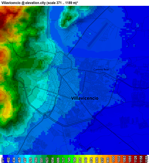
Below is the Elevation map of Villavicencio, which displays elevation range with different colors. Scale of the first map is from 371 to 1189 m (1217 to 3901 ft) with average elevation of 490.5 meters (=1609 ft) [note 1]
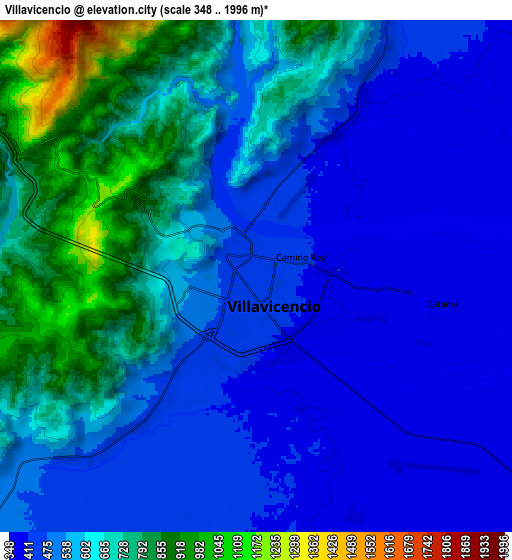
These maps also provides idea of topography and contour of this city, they are displayed at different zoom levels. More info about maps, scale and edge coordinates you can find below images.
| \ | Map #1 | Map #2 | Topo.Map |
| Scale [m] | 371..1189 m | 348..1996 m | × |
| Scale [ft] | 1217..3901 ft | 1142..6549 ft | × |
| Average | 490.5 m = 1609 ft | 573.2 m = 1881 ft | × |
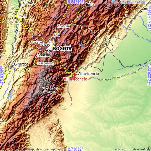
| Width | 9.75 km = 6.1 mi | 19.49 km = 12.1 mi | 311.9 km = 193.8 mi |
| Height | 9.75 km = 6.1 mi | 19.49 km = 12.1 mi | 311.9 km = 193.8 mi |
| ↑Max Latitude | 4.185829° | 4.229656° | 5.54319° |
| Latitude at center | 4.142° | 4.142° | 4.142° |
| ↓Min Latitude | 4.098168° | 4.054334° | 2.73832° |
| ← Min Longitude | -73.670585° | -73.714531° | -75.03289° |
| Longitude center | -73.62664° | -73.62664° | -73.62664° |
| →Max Longitude | -73.582695° | -73.538749° | -72.22039° |
Nearby cities:
Cities around Villavicencio sort by population:
• Acacías elevation 530 m
22.6 km,  220°
220°
• Cumaral 412 m
21.1 km,  47°
47°
• Restrepo 474 m
14.8 km,  29°
29°
• Guamal 522 m
32.9 km,  207°
207°
• Cubarral 589 m
45.3 km, 211°
• Guayabetal 1087 m
22.6 km,  290°
290°
• Castilla La Nueva 417 m
35.7 km,  191°
191°
• Fosca 2112 m
40.9 km,  302°
302°
• Quetame 1585 m
33.6 km,  309°
309°
• Gutiérrez 2295 m
43.5 km, 286°
• El Calvario 1902 m
25.3 km,  338°
338°
• San Juanito 2018 m
36 km,  350°
350°
Multilingual:
 En español:
Villavicencio elevación 441 m.
 En France:
Villavicencio élévation 441 m.
 Auf Deutsch:
Villavicencio höhe über dem Meeresspiegel ist 441 m.

Sources and notes:
- [note 1] Map square and city borders are not equal. Map elevation data is calculated only from area inside that square.
- [src 1] Elevation data from geonames database provided with same terms of usage.
- [src 2] The elevation map of Villavicencio is generated using elevation data from NASA's 3 arcsec (90m) resolution SRTM data.
- [src 3] Base (background) map © OpenStreetMap contributors tiles are generated by Geofabrik and OpenTopoMap.
Copyright & License:
This Villavicencio Elevation Map is licensed under CC BY-SA. You may reuse any part from this page, if you give a proper credit by linking to this URL:
 More info on terms of use page.