Paratebueno elevation
Paratebueno (Cundinamarca), Colombia elevation is 262 meters and Paratebueno elevation in feet is 860 ft above sea level [src 1]. Paratebueno is a seat of a second-order administrative division (feature code) with elevation that is 887 meters (2910 ft) smaller than average city elevation in Colombia.
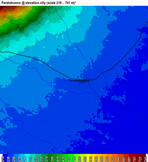
Below is the Elevation map of Paratebueno, which displays elevation range with different colors. Scale of the first map is from 218 to 741 m (715 to 2431 ft) with average elevation of 268.6 meters (=881 ft) [note 1]
These maps also provides idea of topography and contour of this city, they are displayed at different zoom levels. More info about maps, scale and edge coordinates you can find below images.
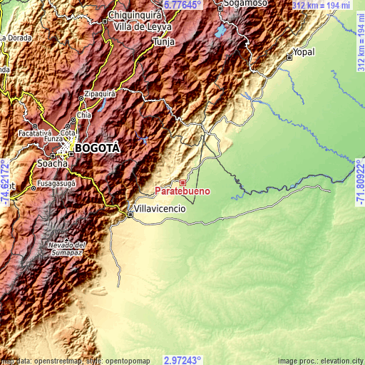
| \ | Map #1 | Topo.Map |
| Scale [m] | 218..741 m | × |
| Scale [ft] | 715..2431 ft | × |
| Average | 268.6 m = 881 ft | × |
| Width | 9.74 km = 6.1 mi | 311.8 km = 193.7 mi |
| Height | 9.74 km = 6.1 mi | 311.8 km = 193.7 mi |
| ↑Max Latitude | 4.419566° | 5.77645° |
| Latitude at center | 4.37575° | 4.37575° |
| ↓Min Latitude | 4.331932° | 2.97243° |
| ← Min Longitude | -73.259415° | -74.62172° |
| Longitude center | -73.21547° | -73.21547° |
| →Max Longitude | -73.171525° | -71.80922° |
Nearby cities:
Cities around Paratebueno sort by population:
• Villavicencio elevation 441 m
52.5 km,  240°
240°
• Puerto López 180 m
42.1 km,  136°
136°
• Cumaral 412 m
32.3 km,  248°
248°
• Restrepo 474 m
40.5 km, 251°
• Medina 536 m
21.1 km,  315°
315°
• San Luis de Gaceno 395 m
49.7 km,  6°
6°
• Gachalá 1729 m
48.8 km, 316°
• Barranca de Upía 236 m
35 km,  51°
51°
• Cabuyaro 165 m
47.9 km,  102°
102°
• Ubalá 1853 m
54.1 km, 319°
• San Juanito 2018 m
52.4 km,  280°
280°
• Villanueva 304 m
41.3 km, 50°
Multilingual:
 En español:
Paratebueno elevación 262 m.
 En France:
Paratebueno élévation 262 m.
 Auf Deutsch:
Paratebueno höhe über dem Meeresspiegel ist 262 m.

Sources and notes:
- [note 1] Map square and city borders are not equal. Map elevation data is calculated only from area inside that square.
- [src 1] Elevation data from geonames database provided with same terms of usage.
- [src 2] The elevation map of Paratebueno is generated using elevation data from NASA's 3 arcsec (90m) resolution SRTM data.
- [src 3] Base (background) map © OpenStreetMap contributors tiles are generated by Geofabrik and OpenTopoMap.
Copyright & License:
This Paratebueno Elevation Map is licensed under CC BY-SA. You may reuse any part from this page, if you give a proper credit by linking to this URL:
 More info on terms of use page.