Gama elevation
Gama (Cundinamarca), Colombia elevation is 2171 meters and Gama elevation in feet is 7123 ft above sea level [src 1]. Gama is a seat of a second-order administrative division (feature code) with elevation that is 1022 meters (3353 ft) bigger than average city elevation in Colombia.
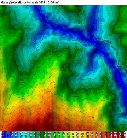
Below is the Elevation map of Gama, which displays elevation range with different colors. Scale of the first map is from 1615 to 3104 m (5299 to 10184 ft) with average elevation of 2165.5 meters (=7105 ft) [note 1]
These maps also provides idea of topography and contour of this city, they are displayed at different zoom levels. More info about maps, scale and edge coordinates you can find below images.
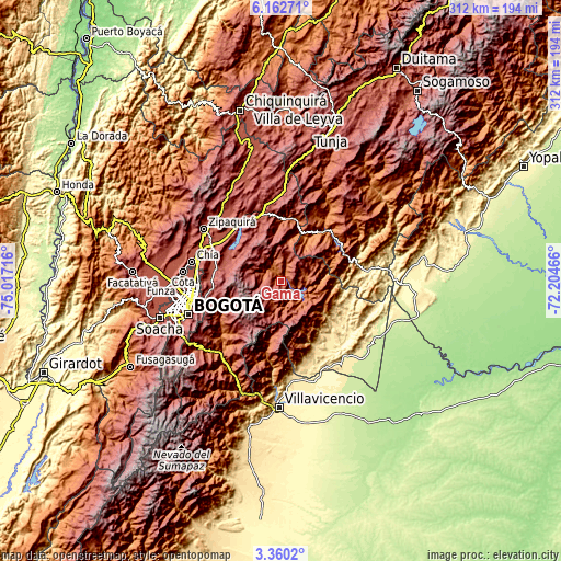
| \ | Map #1 | Topo.Map |
| Scale [m] | 1615..3104 m | × |
| Scale [ft] | 5299..10184 ft | × |
| Average | 2165.5 m = 7105 ft | × |
| Width | 9.74 km = 6.1 mi | 311.6 km = 193.6 mi |
| Height | 9.74 km = 6.1 mi | 311.6 km = 193.6 mi |
| ↑Max Latitude | 4.806672° | 6.16271° |
| Latitude at center | 4.76288° | 4.76288° |
| ↓Min Latitude | 4.719085° | 3.3602° |
| ← Min Longitude | -73.654855° | -75.01716° |
| Longitude center | -73.61091° | -73.61091° |
| →Max Longitude | -73.566965° | -72.20466° |
Nearby cities:
Cities around Gama sort by population:
• Guateque elevation 1801 m
31.1 km,  29°
29°
• Gachetá 1744 m
6.8 km,  335°
335°
• Guasca 2681 m
31.7 km,  291°
291°
• Guayatá 1654 m
26.2 km, 31°
• Guatavita 2700 m
31.3 km,  308°
308°
• Gachalá 1729 m
12.7 km,  127°
127°
• Chivor 1885 m
30.1 km,  63°
63°
• Junín 2376 m
6.2 km,  299°
299°
• Manta 1920 m
28.4 km,  15°
15°
• Somondoco 1801 m
31.6 km,  38°
38°
• Sutatenza 1887 m
33.9 km, 31°
• Ubalá 1853 m
8.7 km,  104°
104°
Multilingual:
 En español:
Gama elevación 2171 m.
 En France:
Gama élévation 2171 m.


Sources and notes:
- [note 1] Map square and city borders are not equal. Map elevation data is calculated only from area inside that square.
- [src 1] Elevation data from geonames database provided with same terms of usage.
- [src 2] The elevation map of Gama is generated using elevation data from NASA's 3 arcsec (90m) resolution SRTM data.
- [src 3] Base (background) map © OpenStreetMap contributors tiles are generated by Geofabrik and OpenTopoMap.
Copyright & License:
This Gama Elevation Map is licensed under CC BY-SA. You may reuse any part from this page, if you give a proper credit by linking to this URL:
 More info on terms of use page.