Thimphu elevation
Thimphu, Bhutan elevation is 2307 meters and Thimphu elevation in feet is 7569 ft above sea level [src 1]. Thimphu is a capital of a political entity (feature code) with elevation that is 795 meters (2608 ft) bigger than average city elevation in Bhutan.
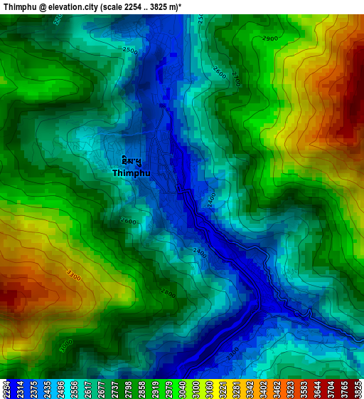
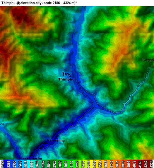
Below is the Elevation map of Thimphu, which displays elevation range with different colors. Scale of the first map is from 2254 to 3825 m (7395 to 12549 ft) with average elevation of 2766.9 meters (=9078 ft) [note 1]
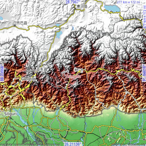
These maps also provides idea of topography and contour of this city, they are displayed at different zoom levels. More info about maps, scale and edge coordinates you can find below images.
| \ | Map #1 | Map #2 | Topo.Map |
| Scale [m] | 2254..3825 m | 2186..4324 m | × |
| Scale [ft] | 7395..12549 ft | 7172..14186 ft | × |
| Average | 2766.9 m = 9078 ft | 2993 m = 9820 ft | × |
| Width | 8.67 km = 5.4 mi | 17.34 km = 10.8 mi | 277.5 km = 172.4 mi |
| Height | 8.67 km = 5.4 mi | 17.34 km = 10.8 mi | 277.5 km = 172.4 mi |
| ↑Max Latitude | 27.505075° | 27.544046° | 28.7067° |
| Latitude at center | 27.46609° | 27.46609° | 27.46609° |
| ↓Min Latitude | 27.427091° | 27.388078° | 26.21136° |
| ← Min Longitude | 89.597965° | 89.554019° | 88.23566° |
| Longitude center | 89.64191° | 89.64191° | 89.64191° |
| →Max Longitude | 89.685855° | 89.729801° | 91.04816° |
Nearby cities:
Cities around Thimphu sort by population:
• Punākha elevation 1293 m
27.1 km,  59°
59°
• Tsirang 1410 m
68.6 km,  136°
136°
• Phuntsholing 330 m
72.8 km,  200°
200°
• Wangdue Phodrang 1273 m
25.5 km,  84°
84°
• Pajo 1438 m
25 km,  72°
72°
• Tsimasham 2245 m
42.1 km,  194°
194°
• Daga 1558 m
49.3 km,  151°
151°
• Paro 2266 m
22.9 km,  260°
260°
• Daphu 914 m
61.1 km, 204°
• Ha 2718 m
36.7 km, 256°
• Gasa 2761 m
49.4 km,  9°
9°
• Lungtenzampa 2319 m
0.3 km,  46°
46°
Multilingual:
 En español:
Timbu elevación 2307 m.
 En France:
Thimphou élévation 2307 m.
 Auf Deutsch:
Thimphu höhe über dem Meeresspiegel ist 2307 m.

Sources and notes:
- [note 1] Map square and city borders are not equal. Map elevation data is calculated only from area inside that square.
- [src 1] Elevation data from geonames database provided with same terms of usage.
- [src 2] The elevation map of Thimphu is generated using elevation data from NASA's 3 arcsec (90m) resolution SRTM data.
- [src 3] Base (background) map © OpenStreetMap contributors tiles are generated by Geofabrik and OpenTopoMap.
Copyright & License:
This Thimphu Elevation Map is licensed under CC BY-SA. You may reuse any part from this page, if you give a proper credit by linking to this URL:
 More info on terms of use page.