Bhutan elevation
On our site we have elevation data and maps for 25 cities from Bhutan including Thimphu as capital of the country.
Bhutan on topographic map
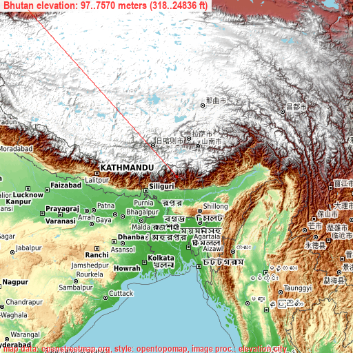
Bhutan elevation extremes
Land surface elevation extremes in Bhutan:
- Highest point in Bhutan: Gangkhar Puensum with 7570 meters (=24836 ft)
- Lowest point: Drangme Chhu with 97 meters (=318 ft)
- Elevation span: 7473 m (=24518 ft)
Statistics
- Main average elevation: 3280 meters (= 10761 ft)
- Average elevation of cities: 1512 m (= 4961 ft), and this is 1116 m (3661 ft) above average city elevation worldwide..[1]
- Area: 47,000 km² (= 18,147 sq mi)
- Population: 699,847


List of cities in ABC order:
Search by letter:
D G H J L M P S T W
D:
Daga Daphu
G:
Gasa
H:
Ha
J:
Jakar
L:
Lhuentse Lungtenzampa
M:
Mongar
P:
Pajo Panbang Paro Pemagatshel Phuntsholing Punākha
S:
Samdrup Jongkhar Samtse Sarpang Shemgang
T:
Thimphu Trashi Yangtse Trashigang Trongsa Tsimasham Tsirang
W:
Wangdue Phodrang
5 most populated cities are in red/bold font style.

D:
Daga Daphu
G:
Gasa
H:
Ha
J:
Jakar
L:
Lhuentse Lungtenzampa
M:
Mongar
P:
Pajo Panbang Paro Pemagatshel Phuntsholing Punākha
S:
Samdrup Jongkhar Samtse Sarpang Shemgang
T:
Thimphu Trashi Yangtse Trashigang Trongsa Tsimasham Tsirang
W:
Wangdue Phodrang
Sources
- Elevation extremes by country from wikipedia.
- Base map data: © OpenStreetMap contributors, | map style: © OpenTopoMap (CC-BY-SA)
- [1] Calculated only from 25 cities in our database
- Other city data from geonames.org with taken over terms of usage.
- Min/max latitude and longitude coordinates per country from latitudelongitude.org website.