Port Moresby elevation
Port Moresby (National Capital), Papua New Guinea elevation is 1 meters and Port Moresby elevation in feet is 3 ft above sea level [src 1]. Port Moresby is a capital of a political entity (feature code) with elevation that is 561 meters (1841 ft) smaller than average city elevation in Papua New Guinea.
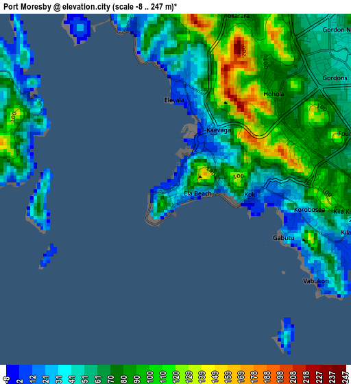
Below is the Elevation map of Port Moresby, which displays elevation range with different colors. Scale of the first map is from -8 to 247 m (-26 to 810 ft) with average elevation of 70 meters (=230 ft) [note 1]
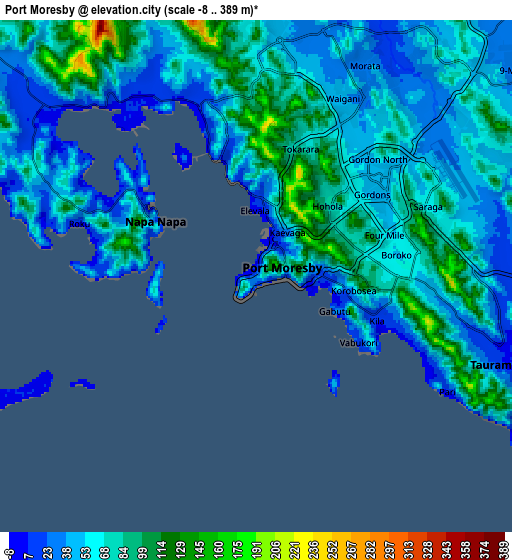
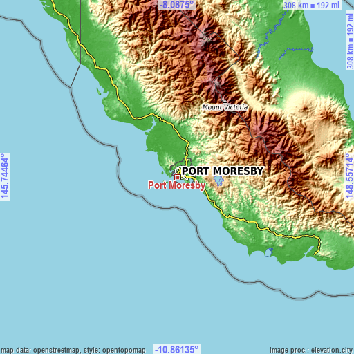
These maps also provides idea of topography and contour of this city, they are displayed at different zoom levels. More info about maps, scale and edge coordinates you can find below images.
| \ | Map #1 | Map #2 | Topo.Map |
| Scale [m] | -8..247 m | -8..389 m | × |
| Scale [ft] | -26..810 ft | -26..1276 ft | × |
| Average | 70 m = 230 ft | 63.3 m = 208 ft | × |
| Width | 9.64 km = 6 mi | 19.28 km = 12 mi | 308.4 km = 191.6 mi |
| Height | 9.64 km = 6 mi | 19.28 km = 12 mi | 308.5 km = 191.7 mi |
| ↑Max Latitude | -9.433882° | -9.390528° | -8.0875° |
| Latitude at center | -9.47723° | -9.47723° | -9.47723° |
| ↓Min Latitude | -9.520573° | -9.56391° | -10.86135° |
| ← Min Longitude | 147.106945° | 147.062999° | 145.74464° |
| Longitude center | 147.15089° | 147.15089° | 147.15089° |
| →Max Longitude | 147.194835° | 147.238781° | 148.55714° |
Nearby cities:
Cities around Port Moresby sort by population:
• Lae elevation 20 m
306.7 km,  356°
356°
• Popondetta 106 m
142.7 km,  56°
56°
• Bulolo 677 m
259 km,  347°
347°
• Wau 1082 m
242.6 km, 348°
• Alotau 11 m
374 km,  104°
104°
• Kainantu 1575 m
381.7 km,  338°
338°
• Kokoda 372 m
92.6 km,  43°
43°
• Kerema 1 m
226.7 km,  318°
318°
• Samarai 8 m
404.5 km,  108°
108°
• Finschhafen 16 m
333.5 km,  13°
13°
• Ihu 11 m
261.2 km,  312°
312°
• Kwikila 68 m
67.5 km,  124°
124°
Multilingual:
 En español:
Puerto Moresby elevación 1 m.
 En France:
Port Moresby élévation 1 m.
 Auf Deutsch:
Port Moresby höhe über dem Meeresspiegel ist 1 m.

Sources and notes:
- [note 1] Map square and city borders are not equal. Map elevation data is calculated only from area inside that square.
- [src 1] Elevation data from geonames database provided with same terms of usage.
- [src 2] The elevation map of Port Moresby is generated using elevation data from NASA's 3 arcsec (90m) resolution SRTM data.
- [src 3] Base (background) map © OpenStreetMap contributors tiles are generated by Geofabrik and OpenTopoMap.
Copyright & License:
This Port Moresby Elevation Map is licensed under CC BY-SA. You may reuse any part from this page, if you give a proper credit by linking to this URL:
 More info on terms of use page.