Kainantu elevation
Kainantu (Eastern Highlands), Papua New Guinea elevation is 1575 meters and Kainantu elevation in feet is 5167 ft above sea level [src 1]. Kainantu is a populated place (feature code) with elevation that is 1013 meters (3323 ft) bigger than average city elevation in Papua New Guinea.
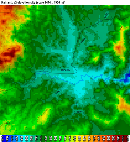
Below is the Elevation map of Kainantu, which displays elevation range with different colors. Scale of the first map is from 1474 to 1936 m (4836 to 6352 ft) with average elevation of 1642.8 meters (=5390 ft) [note 1]
These maps also provides idea of topography and contour of this city, they are displayed at different zoom levels. More info about maps, scale and edge coordinates you can find below images.
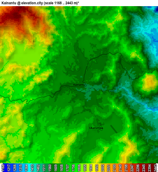
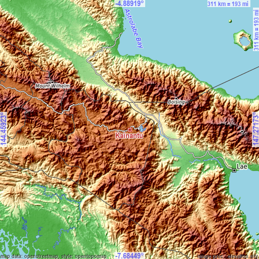
| \ | Map #1 | Map #2 | Topo.Map |
| Scale [m] | 1474..1936 m | 1168..2443 m | × |
| Scale [ft] | 4836..6352 ft | 3832..8015 ft | × |
| Average | 1642.8 m = 5390 ft | 1718.4 m = 5638 ft | × |
| Width | 9.71 km = 6 mi | 19.43 km = 12.1 mi | 310.8 km = 193.1 mi |
| Height | 9.71 km = 6 mi | 19.43 km = 12.1 mi | 310.8 km = 193.1 mi |
| ↑Max Latitude | -6.245037° | -6.201351° | -4.88919° |
| Latitude at center | -6.28872° | -6.28872° | -6.28872° |
| ↓Min Latitude | -6.332399° | -6.376074° | -7.68449° |
| ← Min Longitude | 145.821535° | 145.777589° | 144.45923° |
| Longitude center | 145.86548° | 145.86548° | 145.86548° |
| →Max Longitude | 145.909425° | 145.953371° | 147.27173° |
Nearby cities:
Cities around Kainantu sort by population:
• Lae elevation 20 m
133.9 km,  111°
111°
• Mount Hagen 1728 m
187 km,  284°
284°
• Madang 1 m
119 km,  355°
355°
• Goroka 1524 m
57.6 km,  293°
293°
• Bulolo 677 m
132.9 km,  139°
139°
• Wau 1082 m
149.8 km, 141°
• Kundiawa 1525 m
103.5 km, 286°
• Kerema 1 m
186.1 km,  183°
183°
• Ihu 11 m
186.1 km,  196°
196°
• Rauna 1587 m
184.9 km, 289°
• Kurumul 1591 m
144.7 km, 289°
• Minj 1607 m
136.5 km, 288°
Multilingual:
 En español:
Kainantu elevación 1575 m.
 En France:
Kainantu élévation 1575 m.
 Auf Deutsch:
Kainantu höhe über dem Meeresspiegel ist 1575 m.

Sources and notes:
- [note 1] Map square and city borders are not equal. Map elevation data is calculated only from area inside that square.
- [src 1] Elevation data from geonames database provided with same terms of usage.
- [src 2] The elevation map of Kainantu is generated using elevation data from NASA's 3 arcsec (90m) resolution SRTM data.
- [src 3] Base (background) map © OpenStreetMap contributors tiles are generated by Geofabrik and OpenTopoMap.
Copyright & License:
This Kainantu Elevation Map is licensed under CC BY-SA. You may reuse any part from this page, if you give a proper credit by linking to this URL:
 More info on terms of use page.