Gitega elevation
Gitega, Burundi elevation is 1849 meters and Gitega elevation in feet is 6066 ft above sea level [src 1]. Gitega is a capital of a political entity (feature code) with elevation that is 365 meters (1198 ft) bigger than average city elevation in Burundi.
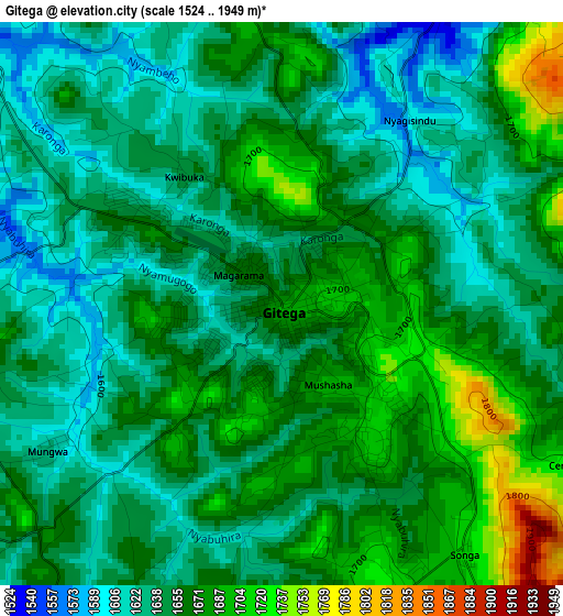
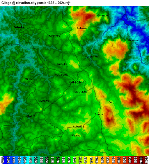
Below is the Elevation map of Gitega, which displays elevation range with different colors. Scale of the first map is from 1524 to 1949 m (5000 to 6394 ft) with average elevation of 1654.8 meters (=5429 ft) [note 1]
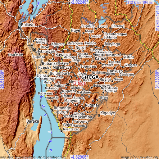
These maps also provides idea of topography and contour of this city, they are displayed at different zoom levels. More info about maps, scale and edge coordinates you can find below images.
| \ | Map #1 | Map #2 | Topo.Map |
| Scale [m] | 1524..1949 m | 1392..2024 m | × |
| Scale [ft] | 5000..6394 ft | 4567..6640 ft | × |
| Average | 1654.8 m = 5429 ft | 1649.6 m = 5412 ft | × |
| Width | 9.75 km = 6.1 mi | 19.51 km = 12.1 mi | 312.1 km = 193.9 mi |
| Height | 9.76 km = 6.1 mi | 19.51 km = 12.1 mi | 312.2 km = 194 mi |
| ↑Max Latitude | -3.383212° | -3.339343° | -2.02246° |
| Latitude at center | -3.42708° | -3.42708° | -3.42708° |
| ↓Min Latitude | -3.470946° | -3.514809° | -4.82965° |
| ← Min Longitude | 29.880685° | 29.836739° | 28.51838° |
| Longitude center | 29.92463° | 29.92463° | 29.92463° |
| →Max Longitude | 29.968575° | 30.012521° | 31.33088° |
Nearby cities:
Cities around Gitega sort by population:
• Bujumbura elevation 795 m
62.7 km,  274°
274°
• Ruyigi 1596 m
36.4 km,  98°
98°
• Ngozi 1824 m
58.7 km,  349°
349°
• Rutana 1792 m
56.2 km,  172°
172°
• Bururi 1857 m
66.9 km,  209°
209°
• Kayanza 1918 m
65 km,  329°
329°
• Muramvya 1878 m
39.3 km,  296°
296°
• Bubanza 1079 m
70.7 km, 303°
• Karuzi 1627 m
44.8 km,  36°
36°
• Mwaro 1974 m
26.3 km,  249°
249°
• Muzinda 906 m
58.9 km,  288°
288°
• Isale 1728 m
49.7 km,  280°
280°
Multilingual:
 En español:
Gitega elevación 1849 m.
 En France:
Gitega élévation 1849 m.


Sources and notes:
- [note 1] Map square and city borders are not equal. Map elevation data is calculated only from area inside that square.
- [src 1] Elevation data from geonames database provided with same terms of usage.
- [src 2] The elevation map of Gitega is generated using elevation data from NASA's 3 arcsec (90m) resolution SRTM data.
- [src 3] Base (background) map © OpenStreetMap contributors tiles are generated by Geofabrik and OpenTopoMap.
Copyright & License:
This Gitega Elevation Map is licensed under CC BY-SA. You may reuse any part from this page, if you give a proper credit by linking to this URL:
 More info on terms of use page.