Basseterre elevation
Basseterre (Saint George Basseterre), Saint Kitts and Nevis elevation is 1 meters and Basseterre elevation in feet is 3 ft above sea level [src 1]. Basseterre is a capital of a political entity (feature code) with elevation that is 67 meters (220 ft) smaller than average city elevation in Saint Kitts and Nevis.
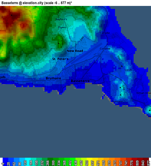
Below is the Elevation map of Basseterre, which displays elevation range with different colors. Scale of the first map is from -6 to 877 m (-20 to 2877 ft) with average elevation of 170.6 meters (=560 ft) [note 1]
These maps also provides idea of topography and contour of this city, they are displayed at different zoom levels. More info about maps, scale and edge coordinates you can find below images.
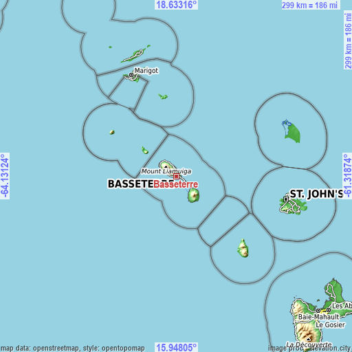
| \ | Map #1 | Map #2 | Topo.Map |
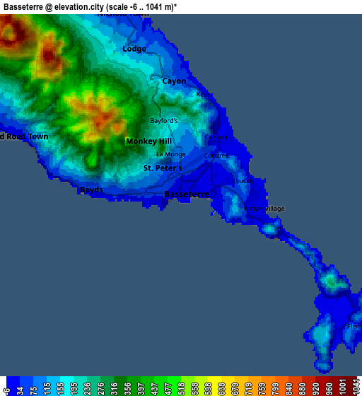
| Scale [m] | -6..877 m | -6..1041 m | × |
| Scale [ft] | -20..2877 ft | -20..3415 ft | × |
| Average | 170.6 m = 560 ft | 232.3 m = 762 ft | × |
| Width | 9.33 km = 5.8 mi | 18.66 km = 11.6 mi | 298.6 km = 185.5 mi |
| Height | 9.33 km = 5.8 mi | 18.66 km = 11.6 mi | 298.6 km = 185.5 mi |
| ↑Max Latitude | 17.337454° | 17.379397° | 18.63316° |
| Latitude at center | 17.2955° | 17.2955° | 17.2955° |
| ↓Min Latitude | 17.253537° | 17.211564° | 15.94805° |
| ← Min Longitude | -62.768935° | -62.812881° | -64.13124° |
| Longitude center | -62.72499° | -62.72499° | -62.72499° |
| →Max Longitude | -62.681045° | -62.637099° | -61.31874° |
Nearby cities:
Cities around Basseterre sort by population:
• Fig Tree elevation 115 m
22.9 km,  145°
145°
• Saint Paul’s 59 m
17 km,  316°
316°
• Middle Island 14 m
9.7 km,  290°
290°
• Nicola Town 47 m
9.8 km,  342°
342°
• Trinity 41 m
5.4 km,  275°
275°
• Charlestown 46 m
21.4 km, 147°
• Cayon 109 m
6.1 km,  351°
351°
• Sandy Point Town 23 m
14.9 km,  298°
298°
• Dieppe Bay Town 20 m
16.3 km, 324°
• Monkey Hill 148 m
3.1 km, 351°
• Newcastle 27 m
18.4 km,  125°
125°
• Cotton Ground 83 m
18.4 km,  141°
141°
Multilingual:
 En español:
Basseterre elevación 1 m.
 En France:
Basseterre élévation 1 m.
 Auf Deutsch:
Basseterre höhe über dem Meeresspiegel ist 1 m.

Sources and notes:
- [note 1] Map square and city borders are not equal. Map elevation data is calculated only from area inside that square.
- [src 1] Elevation data from geonames database provided with same terms of usage.
- [src 2] The elevation map of Basseterre is generated using elevation data from NASA's 3 arcsec (90m) resolution SRTM data.
- [src 3] Base (background) map © OpenStreetMap contributors tiles are generated by Geofabrik and OpenTopoMap.
Copyright & License:
This Basseterre Elevation Map is licensed under CC BY-SA. You may reuse any part from this page, if you give a proper credit by linking to this URL:
 More info on terms of use page.