Az Zubaydāt elevation
Az Zubaydāt, Palestinian Territory elevation is -261 meters and Az Zubaydāt elevation in feet is -856 ft above sea level [src 1]. Az Zubaydāt is a populated place (feature code) with elevation that is 728 meters (2388 ft) smaller than average city elevation in Palestinian Territory.
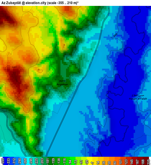
Below is the Elevation map of Az Zubaydāt, which displays elevation range with different colors. Scale of the first map is from -355 to 210 m (-1165 to 689 ft) with average elevation of -196.3 meters (=-644 ft) [note 1]
These maps also provides idea of topography and contour of this city, they are displayed at different zoom levels. More info about maps, scale and edge coordinates you can find below images.
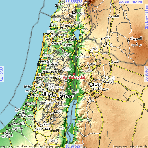
| \ | Map #1 | Topo.Map |
| Scale [m] | -355..210 m | × |
| Scale [ft] | -1165..689 ft | × |
| Average | -196.3 m = -644 ft | × |
| Width | 8.27 km = 5.1 mi | 264.7 km = 164.5 mi |
| Height | 8.27 km = 5.1 mi | 264.7 km = 164.5 mi |
| ↑Max Latitude | 32.21049° | 33.35578° |
| Latitude at center | 32.1733° | 32.1733° |
| ↓Min Latitude | 32.136095° | 30.97527° |
| ← Min Longitude | 35.486105° | 34.1238° |
| Longitude center | 35.53005° | 35.53005° |
| →Max Longitude | 35.573995° | 36.9363° |
Nearby cities:
Cities around Az Zubaydāt sort by population:
• Ţammūn elevation 356 m
18.4 km,  311°
311°
• Bayt Fūrīk 532 m
18.3 km,  271°
271°
• ‘Aqrabā 622 m
18.2 km,  252°
252°
• Sālim 517 m
19.2 km,  282°
282°
• Al Jiftlik -246 m
5.4 km,  227°
227°
• Bayt Dajan 525 m
15.1 km, 278°
• Dayr al Ḩaţab 509 m
20.2 km, 283°
• Domea 617 m
20.1 km, 229°
• Majdal Banī Fāḑil 662 m
18.6 km,  237°
237°
• An Naşşārīyah -16 m
15.2 km,  297°
297°
• Bayt Ḩasan -37 m
13.8 km, 301°
• Al Faşāyil -251 m
18.4 km,  206°
206°
Multilingual:
 En español:
Az Zubaydāt elevación -261 m.
 En France:
Az Zubaydāt élévation -261 m.
 Auf Deutsch:
Az Zubaydāt höhe über dem Meeresspiegel ist -261 m.

Sources and notes:
- [note 1] Map square and city borders are not equal. Map elevation data is calculated only from area inside that square.
- [src 1] Elevation data from geonames database provided with same terms of usage.
- [src 2] The elevation map of Az Zubaydāt is generated using elevation data from NASA's 3 arcsec (90m) resolution SRTM data.
- [src 3] Base (background) map © OpenStreetMap contributors tiles are generated by Geofabrik and OpenTopoMap.
Copyright & License:
This Az Zubaydāt Elevation Map is licensed under CC BY-SA. You may reuse any part from this page, if you give a proper credit by linking to this URL:
 More info on terms of use page.