‘Aqrabā elevation
‘Aqrabā (West Bank, Nablus), Palestinian Territory elevation is 622 meters and ‘Aqrabā elevation in feet is 2041 ft above sea level [src 1]. ‘Aqrabā is a populated place (feature code) with elevation that is 155 meters (509 ft) bigger than average city elevation in Palestinian Territory.
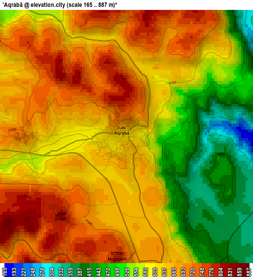
Below is the Elevation map of ‘Aqrabā, which displays elevation range with different colors. Scale of the first map is from 165 to 887 m (541 to 2910 ft) with average elevation of 612.2 meters (=2009 ft) [note 1]
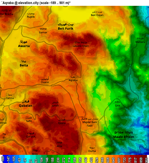
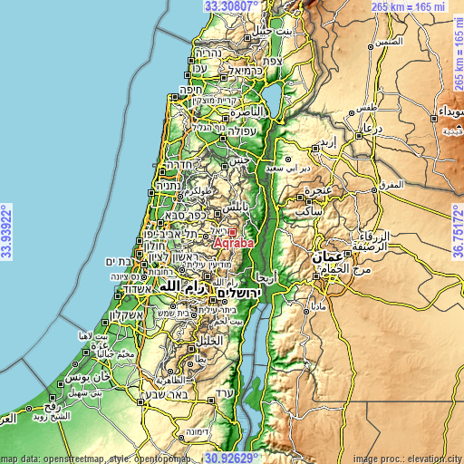
These maps also provides idea of topography and contour of this city, they are displayed at different zoom levels. More info about maps, scale and edge coordinates you can find below images.
| \ | Map #1 | Map #2 | Topo.Map |
| Scale [m] | 165..887 m | -189..901 m | × |
| Scale [ft] | 541..2910 ft | -620..2956 ft | × |
| Average | 612.2 m = 2009 ft | 508 m = 1667 ft | × |
| Width | 8.28 km = 5.1 mi | 16.55 km = 10.3 mi | 264.8 km = 164.5 mi |
| Height | 8.28 km = 5.1 mi | 16.55 km = 10.3 mi | 264.8 km = 164.5 mi |
| ↑Max Latitude | 32.162159° | 32.199353° | 33.30807° |
| Latitude at center | 32.12495° | 32.12495° | 32.12495° |
| ↓Min Latitude | 32.087726° | 32.050486° | 30.92629° |
| ← Min Longitude | 35.301525° | 35.257579° | 33.93922° |
| Longitude center | 35.34547° | 35.34547° | 35.34547° |
| →Max Longitude | 35.389415° | 35.433361° | 36.75172° |
Nearby cities:
Cities around ‘Aqrabā sort by population:
• Bayt Fūrīk elevation 532 m
5.9 km,  350°
350°
• Baytā al Fawqā 587 m
5.8 km,  289°
289°
• Qabalān 620 m
5.9 km,  244°
244°
• ‘Awartā 549 m
7.1 km,  304°
304°
• Quşrah 753 m
4.6 km,  198°
198°
• Talfīt 693 m
6.7 km,  230°
230°
• Yatmā 594 m
7.4 km,  256°
256°
• Qaryūt 791 m
7.8 km,  218°
218°
• Majdal Banī Fāḑil 662 m
4.9 km,  159°
159°
• Usarin 702 m
3.3 km,  270°
270°
• Jūrīsh 807 m
3.4 km, 220°
• Ūdalah 535 m
7.2 km, 296°
Multilingual:
 En español:
‘Aqrabā elevación 622 m.
 En France:
‘Aqrabā élévation 622 m.


Sources and notes:
- [note 1] Map square and city borders are not equal. Map elevation data is calculated only from area inside that square.
- [src 1] Elevation data from geonames database provided with same terms of usage.
- [src 2] The elevation map of ‘Aqrabā is generated using elevation data from NASA's 3 arcsec (90m) resolution SRTM data.
- [src 3] Base (background) map © OpenStreetMap contributors tiles are generated by Geofabrik and OpenTopoMap.
Copyright & License:
This ‘Aqrabā Elevation Map is licensed under CC BY-SA. You may reuse any part from this page, if you give a proper credit by linking to this URL:
 More info on terms of use page.