‘Awartā elevation
‘Awartā (West Bank, Nablus), Palestinian Territory elevation is 549 meters and ‘Awartā elevation in feet is 1801 ft above sea level [src 1]. ‘Awartā is a populated place (feature code) with elevation that is 82 meters (269 ft) bigger than average city elevation in Palestinian Territory.
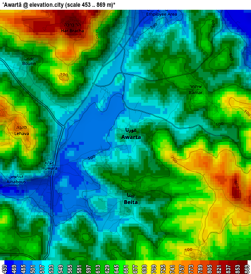
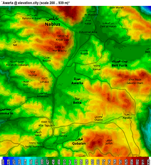
Below is the Elevation map of ‘Awartā, which displays elevation range with different colors. Scale of the first map is from 453 to 869 m (1486 to 2851 ft) with average elevation of 596.5 meters (=1957 ft) [note 1]
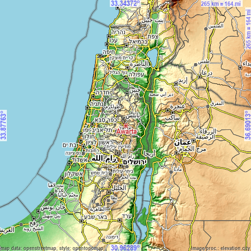
These maps also provides idea of topography and contour of this city, they are displayed at different zoom levels. More info about maps, scale and edge coordinates you can find below images.
| \ | Map #1 | Map #2 | Topo.Map |
| Scale [m] | 453..869 m | 200..939 m | × |
| Scale [ft] | 1486..2851 ft | 656..3081 ft | × |
| Average | 596.5 m = 1957 ft | 597.4 m = 1960 ft | × |
| Width | 8.27 km = 5.1 mi | 16.55 km = 10.3 mi | 264.7 km = 164.5 mi |
| Height | 8.27 km = 5.1 mi | 16.55 km = 10.3 mi | 264.7 km = 164.5 mi |
| ↑Max Latitude | 32.198275° | 32.235454° | 33.34372° |
| Latitude at center | 32.16108° | 32.16108° | 32.16108° |
| ↓Min Latitude | 32.12387° | 32.086645° | 30.96289° |
| ← Min Longitude | 35.239935° | 35.195989° | 33.87763° |
| Longitude center | 35.28388° | 35.28388° | 35.28388° |
| →Max Longitude | 35.327825° | 35.371771° | 36.69013° |
Nearby cities:
Cities around ‘Awartā sort by population:
• Balāţah elevation 494 m
5.7 km,  1°
1°
• Bayt Fūrīk 532 m
5.2 km,  70°
70°
• Baytā al Fawqā 587 m
2.1 km,  169°
169°
• Ḩuwwārah 522 m
2.7 km,  248°
248°
• Rūjayb 528 m
3.4 km,  15°
15°
• ‘Ūrīf 584 m
5.8 km,  268°
268°
• Būrīn 589 m
4.1 km,  309°
309°
• Kafr Qallīl 531 m
3.6 km,  358°
358°
• ‘Aynabūs 506 m
4 km, 246°
• Mādamā 509 m
5.7 km,  299°
299°
• Usarin 702 m
4.7 km,  148°
148°
• Ūdalah 535 m
1.1 km,  220°
220°
Multilingual:
 En español:
‘Awartā elevación 549 m.
 En France:
‘Awartā élévation 549 m.


Sources and notes:
- [note 1] Map square and city borders are not equal. Map elevation data is calculated only from area inside that square.
- [src 1] Elevation data from geonames database provided with same terms of usage.
- [src 2] The elevation map of ‘Awartā is generated using elevation data from NASA's 3 arcsec (90m) resolution SRTM data.
- [src 3] Base (background) map © OpenStreetMap contributors tiles are generated by Geofabrik and OpenTopoMap.
Copyright & License:
This ‘Awartā Elevation Map is licensed under CC BY-SA. You may reuse any part from this page, if you give a proper credit by linking to this URL:
 More info on terms of use page.