Ţammūn elevation
Ţammūn (West Bank, Tubas), Palestinian Territory elevation is 356 meters and Ţammūn elevation in feet is 1168 ft above sea level [src 1]. Ţammūn is a populated place (feature code) with elevation that is 111 meters (364 ft) smaller than average city elevation in Palestinian Territory.
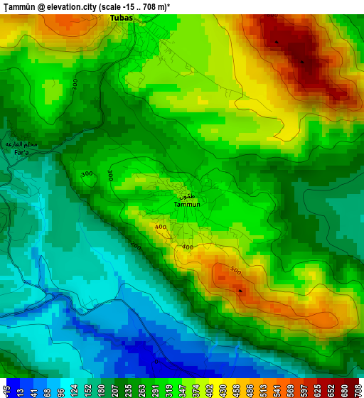
Below is the Elevation map of Ţammūn, which displays elevation range with different colors. Scale of the first map is from -15 to 708 m (-49 to 2323 ft) with average elevation of 285.2 meters (=936 ft) [note 1]
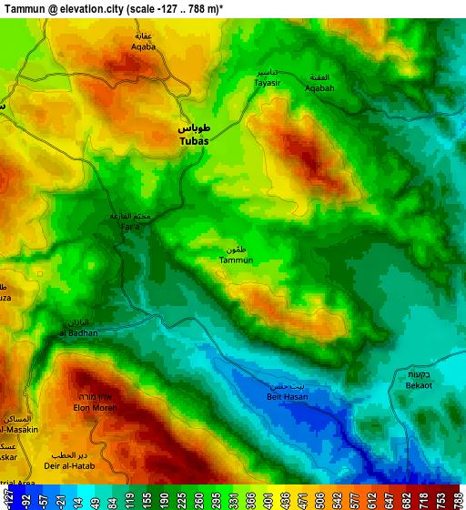
These maps also provides idea of topography and contour of this city, they are displayed at different zoom levels. More info about maps, scale and edge coordinates you can find below images.
| \ | Map #1 | Map #2 | Topo.Map |
| Scale [m] | -15..708 m | -127..788 m | × |
| Scale [ft] | -49..2323 ft | -417..2585 ft | × |
| Average | 285.2 m = 936 ft | 291.3 m = 956 ft | × |
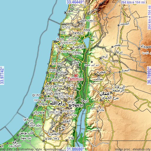
| Width | 8.26 km = 5.1 mi | 16.52 km = 10.3 mi | 264.4 km = 164.3 mi |
| Height | 8.26 km = 5.1 mi | 16.52 km = 10.3 mi | 264.4 km = 164.3 mi |
| ↑Max Latitude | 32.320614° | 32.357744° | 33.46449° |
| Latitude at center | 32.28347° | 32.28347° | 32.28347° |
| ↓Min Latitude | 32.24631° | 32.209135° | 31.08686° |
| ← Min Longitude | 35.339725° | 35.295779° | 33.97742° |
| Longitude center | 35.38367° | 35.38367° | 35.38367° |
| →Max Longitude | 35.427615° | 35.471561° | 36.78992° |
Nearby cities:
Cities around Ţammūn sort by population:
• Ţūbās elevation 375 m
4.4 km,  342°
342°
• Sālim 517 m
9.6 km,  211°
211°
• Sīrīs 425 m
10 km,  299°
299°
• Al Judayyidah 425 m
9.7 km,  306°
306°
• Bayt Dajan 525 m
10.1 km,  186°
186°
• ‘Azmūţ 473 m
9.7 km,  225°
225°
• Ţallūzah 543 m
8.5 km,  260°
260°
• Al Bādhān 104 m
5.6 km,  240°
240°
• Tayāsīr 292 m
6.4 km,  10°
10°
• Dayr al Ḩaţab 509 m
9.4 km,  218°
218°
• An Naşşārīyah -16 m
5.2 km,  176°
176°
• Bayt Ḩasan -37 m
5.4 km,  159°
159°
Multilingual:
 En español:
Ţammūn elevación 356 m.
 En France:
Ţammūn élévation 356 m.


Sources and notes:
- [note 1] Map square and city borders are not equal. Map elevation data is calculated only from area inside that square.
- [src 1] Elevation data from geonames database provided with same terms of usage.
- [src 2] The elevation map of Ţammūn is generated using elevation data from NASA's 3 arcsec (90m) resolution SRTM data.
- [src 3] Base (background) map © OpenStreetMap contributors tiles are generated by Geofabrik and OpenTopoMap.
Copyright & License:
This Ţammūn Elevation Map is licensed under CC BY-SA. You may reuse any part from this page, if you give a proper credit by linking to this URL:
 More info on terms of use page.