Soma elevation
Soma (Manisa), Turkey elevation is 155 meters and Soma elevation in feet is 509 ft above sea level [src 1]. Soma is a seat of a second-order administrative division (feature code) with elevation that is 568 meters (1864 ft) smaller than average city elevation in Turkey.
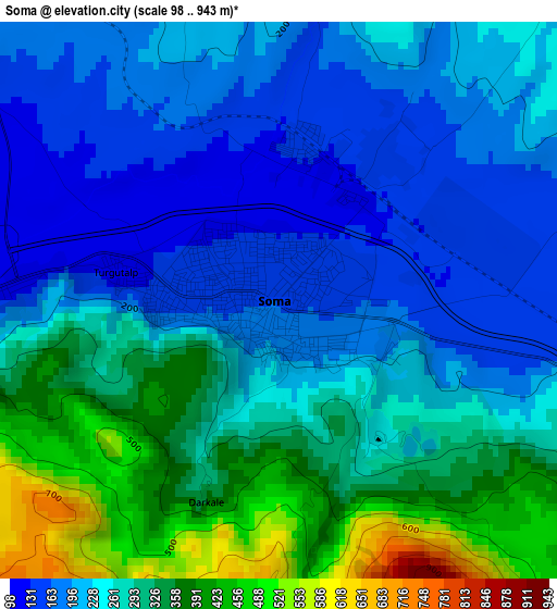
Below is the Elevation map of Soma, which displays elevation range with different colors. Scale of the first map is from 98 to 943 m (322 to 3094 ft) with average elevation of 262.1 meters (=860 ft) [note 1]
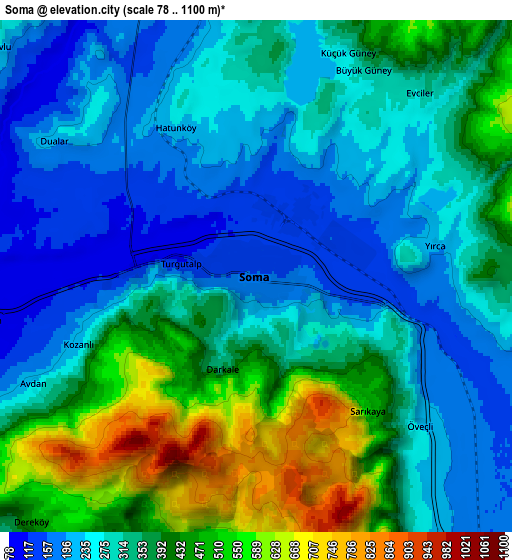
These maps also provides idea of topography and contour of this city, they are displayed at different zoom levels. More info about maps, scale and edge coordinates you can find below images.
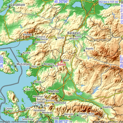
| \ | Map #1 | Map #2 | Topo.Map |
| Scale [m] | 98..943 m | 78..1100 m | × |
| Scale [ft] | 322..3094 ft | 256..3609 ft | × |
| Average | 262.1 m = 860 ft | 336.3 m = 1103 ft | × |
| Width | 7.57 km = 4.7 mi | 15.15 km = 9.4 mi | 242.4 km = 150.6 mi |
| Height | 7.57 km = 4.7 mi | 15.15 km = 9.4 mi | 242.4 km = 150.6 mi |
| ↑Max Latitude | 39.219594° | 39.253631° | 40.26706° |
| Latitude at center | 39.18554° | 39.18554° | 39.18554° |
| ↓Min Latitude | 39.15147° | 39.117383° | 38.08712° |
| ← Min Longitude | 27.565505° | 27.521559° | 26.2032° |
| Longitude center | 27.60945° | 27.60945° | 27.60945° |
| →Max Longitude | 27.653395° | 27.697341° | 29.0157° |
Nearby cities:
Cities around Soma sort by population:
• Akhisar elevation 103 m
35.7 km,  146°
146°
• Kırkağaç 213 m
10.2 km, 149°
• Kınık 84 m
22.4 km,  240°
240°
• Savaştepe 295 m
22.3 km,  10°
10°
• Zeytinliova 236 m
22.4 km,  165°
165°
• Kayapa 310 m
37 km,  337°
337°
• Gölcük 441 m
35.2 km,  66°
66°
• Konakpınar 373 m
33.8 km,  35°
35°
• Turanlı 232 m
26.5 km,  292°
292°
• Sarıbeyler 260 m
23.8 km,  353°
353°
• Gelembe 238 m
20.6 km,  92°
92°
• Göçbeyli 85 m
18.2 km,  283°
283°
Multilingual:
 En español:
Soma elevación 155 m.
 En France:
Soma élévation 155 m.


Sources and notes:
- [note 1] Map square and city borders are not equal. Map elevation data is calculated only from area inside that square.
- [src 1] Elevation data from geonames database provided with same terms of usage.
- [src 2] The elevation map of Soma is generated using elevation data from NASA's 3 arcsec (90m) resolution SRTM data.
- [src 3] Base (background) map © OpenStreetMap contributors tiles are generated by Geofabrik and OpenTopoMap.
Copyright & License:
This Soma Elevation Map is licensed under CC BY-SA. You may reuse any part from this page, if you give a proper credit by linking to this URL:
 More info on terms of use page.