Patnos elevation
Patnos (Ağrı), Turkey elevation is 1630 meters and Patnos elevation in feet is 5348 ft above sea level [src 1]. Patnos is a seat of a second-order administrative division (feature code) with elevation that is 907 meters (2976 ft) bigger than average city elevation in Turkey.
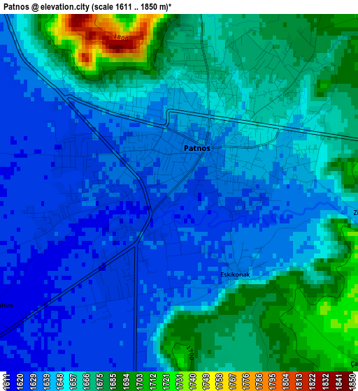
Below is the Elevation map of Patnos, which displays elevation range with different colors. Scale of the first map is from 1611 to 1850 m (5285 to 6070 ft) with average elevation of 1653.4 meters (=5425 ft) [note 1]
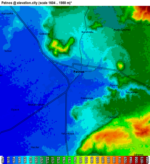
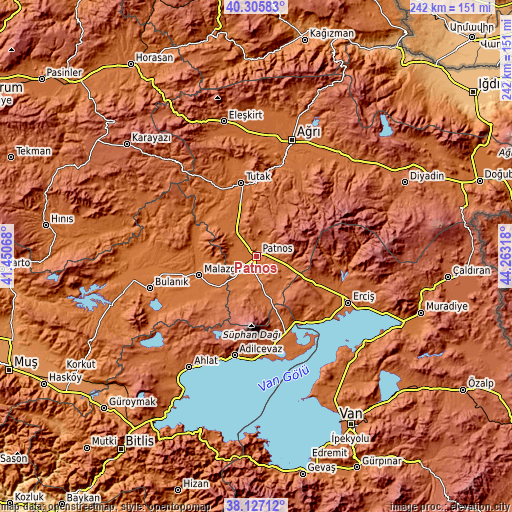
These maps also provides idea of topography and contour of this city, they are displayed at different zoom levels. More info about maps, scale and edge coordinates you can find below images.
| \ | Map #1 | Map #2 | Topo.Map |
| Scale [m] | 1611..1850 m | 1604..1988 m | × |
| Scale [ft] | 5285..6070 ft | 5262..6522 ft | × |
| Average | 1653.4 m = 5425 ft | 1682.1 m = 5519 ft | × |
| Width | 7.57 km = 4.7 mi | 15.14 km = 9.4 mi | 242.2 km = 150.5 mi |
| Height | 7.57 km = 4.7 mi | 15.14 km = 9.4 mi | 242.2 km = 150.5 mi |
| ↑Max Latitude | 39.258965° | 39.292983° | 40.30583° |
| Latitude at center | 39.22493° | 39.22493° | 39.22493° |
| ↓Min Latitude | 39.190879° | 39.156811° | 38.12712° |
| ← Min Longitude | 42.812985° | 42.769039° | 41.45068° |
| Longitude center | 42.85693° | 42.85693° | 42.85693° |
| →Max Longitude | 42.900875° | 42.944821° | 44.26318° |
Nearby cities:
Cities around Patnos sort by population:
• Erciş elevation 1682 m
48.7 km,  117°
117°
• Adilcevaz 1652 m
48.6 km,  192°
192°
• Malazgirt 1510 m
29.1 km,  252°
252°
• Hamur 1693 m
43.7 km,  14°
14°
• Göldüzü 1657 m
47.9 km,  162°
162°
• Nurettin 1547 m
37.8 km,  270°
270°
• Tutak 1559 m
35.7 km,  347°
347°
• Kocapınar 1788 m
32.6 km, 116°
• Nurettin 1501 m
30.7 km,  281°
281°
• Sarısu 1785 m
23.6 km,  166°
166°
• Dedeli 1794 m
18 km,  108°
108°
• Doğansu 1619 m
14.9 km,  226°
226°
Multilingual:
 En español:
Patnos elevación 1630 m.
 En France:
Patnos élévation 1630 m.


Sources and notes:
- [note 1] Map square and city borders are not equal. Map elevation data is calculated only from area inside that square.
- [src 1] Elevation data from geonames database provided with same terms of usage.
- [src 2] The elevation map of Patnos is generated using elevation data from NASA's 3 arcsec (90m) resolution SRTM data.
- [src 3] Base (background) map © OpenStreetMap contributors tiles are generated by Geofabrik and OpenTopoMap.
Copyright & License:
This Patnos Elevation Map is licensed under CC BY-SA. You may reuse any part from this page, if you give a proper credit by linking to this URL:
 More info on terms of use page.