Hamur elevation
Hamur (Ağrı), Turkey elevation is 1693 meters and Hamur elevation in feet is 5554 ft above sea level [src 1]. Hamur is a seat of a second-order administrative division (feature code) with elevation that is 970 meters (3182 ft) bigger than average city elevation in Turkey.
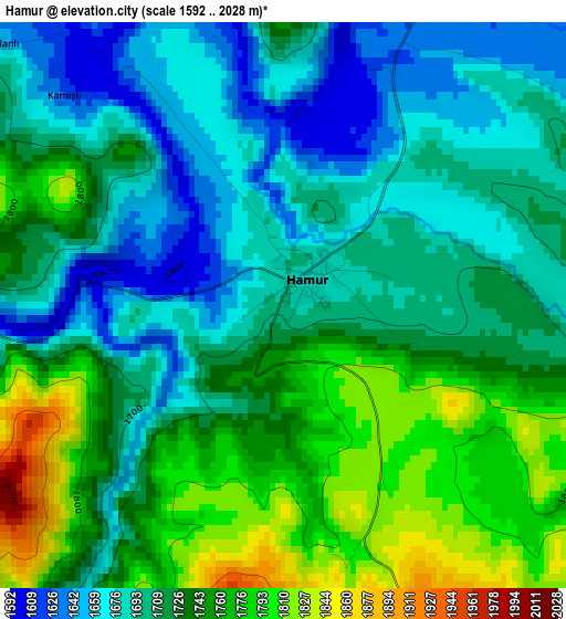
Below is the Elevation map of Hamur, which displays elevation range with different colors. Scale of the first map is from 1592 to 2028 m (5223 to 6654 ft) with average elevation of 1722.3 meters (=5651 ft) [note 1]
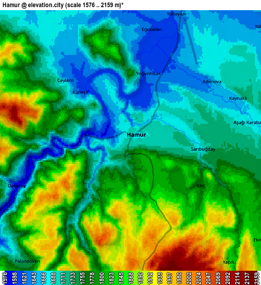
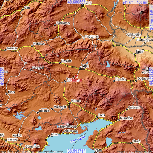
These maps also provides idea of topography and contour of this city, they are displayed at different zoom levels. More info about maps, scale and edge coordinates you can find below images.
| \ | Map #1 | Map #2 | Topo.Map |
| Scale [m] | 1592..2028 m | 1576..2159 m | × |
| Scale [ft] | 5223..6654 ft | 5171..7083 ft | × |
| Average | 1722.3 m = 5651 ft | 1767.9 m = 5800 ft | × |
| Width | 7.53 km = 4.7 mi | 15.06 km = 9.4 mi | 240.9 km = 149.7 mi |
| Height | 7.53 km = 4.7 mi | 15.06 km = 9.4 mi | 240.9 km = 149.7 mi |
| ↑Max Latitude | 39.639459° | 39.673292° | 40.68056° |
| Latitude at center | 39.60561° | 39.60561° | 39.60561° |
| ↓Min Latitude | 39.571744° | 39.537861° | 38.51371° |
| ← Min Longitude | 42.941055° | 42.897109° | 41.57875° |
| Longitude center | 42.985° | 42.985° | 42.985° |
| →Max Longitude | 43.028945° | 43.072891° | 44.39125° |
Nearby cities:
Cities around Hamur sort by population:
• Ağrı elevation 1640 m
13.9 km,  24°
24°
• Patnos 1630 m
43.7 km,  194°
194°
• Eleşkirt 1813 m
34 km,  308°
308°
• Taşlıçay 1736 m
33 km,  85°
85°
• Elmalıdere 2023 m
57.1 km,  273°
273°
• Doğansu 1619 m
56.9 km,  202°
202°
• Tahir 2129 m
55.1 km,  300°
300°
• Nurettin 1501 m
54.6 km,  228°
228°
• Dedeli 1794 m
48.3 km,  172°
172°
• Cumaçay 1959 m
38.5 km,  26°
26°
• Murat 1678 m
23 km,  71°
71°
• Tutak 1559 m
20.2 km,  248°
248°
Multilingual:
 En español:
Hamur elevación 1693 m.
 En France:
Hamur élévation 1693 m.


Sources and notes:
- [note 1] Map square and city borders are not equal. Map elevation data is calculated only from area inside that square.
- [src 1] Elevation data from geonames database provided with same terms of usage.
- [src 2] The elevation map of Hamur is generated using elevation data from NASA's 3 arcsec (90m) resolution SRTM data.
- [src 3] Base (background) map © OpenStreetMap contributors tiles are generated by Geofabrik and OpenTopoMap.
Copyright & License:
This Hamur Elevation Map is licensed under CC BY-SA. You may reuse any part from this page, if you give a proper credit by linking to this URL:
 More info on terms of use page.