Ağrı elevation
Ağrı, Turkey elevation is 1640 meters and Ağrı elevation in feet is 5381 ft above sea level [src 1]. Ağrı is a seat of a first-order administrative division (feature code) with elevation that is 917 meters (3009 ft) bigger than average city elevation in Turkey.
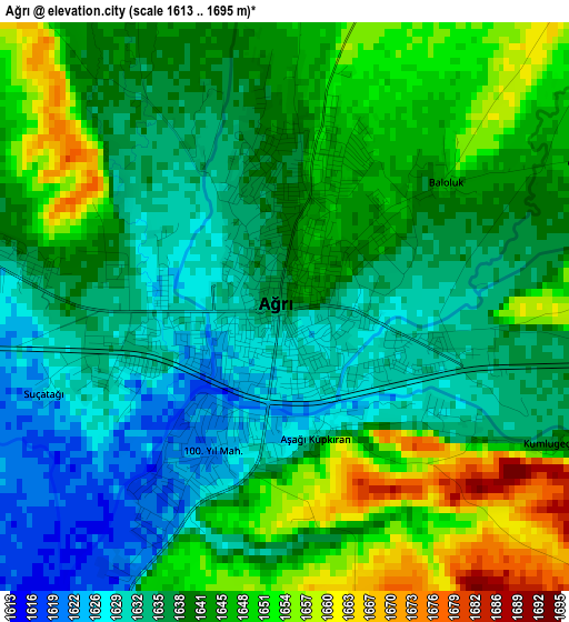
Below is the Elevation map of Ağrı, which displays elevation range with different colors. Scale of the first map is from 1613 to 1695 m (5292 to 5561 ft) with average elevation of 1640.8 meters (=5383 ft) [note 1]
These maps also provides idea of topography and contour of this city, they are displayed at different zoom levels. More info about maps, scale and edge coordinates you can find below images.
| \ | Map #1 | Map #2 | Topo.Map |
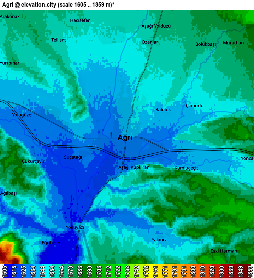
| Scale [m] | 1613..1695 m | 1605..1859 m | × |
| Scale [ft] | 5292..5561 ft | 5266..6099 ft | × |
| Average | 1640.8 m = 5383 ft | 1654.4 m = 5428 ft | × |
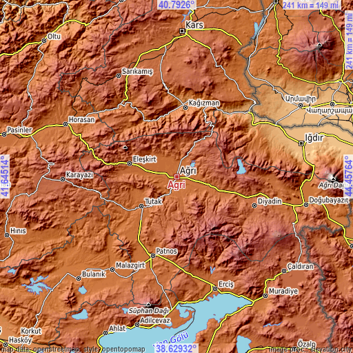
| Width | 7.52 km = 4.7 mi | 15.03 km = 9.3 mi | 240.5 km = 149.4 mi |
| Height | 7.52 km = 4.7 mi | 15.03 km = 9.3 mi | 240.5 km = 149.4 mi |
| ↑Max Latitude | 39.753234° | 39.787011° | 40.7926° |
| Latitude at center | 39.71944° | 39.71944° | 39.71944° |
| ↓Min Latitude | 39.68563° | 39.651803° | 38.62932° |
| ← Min Longitude | 43.007445° | 42.963499° | 41.64514° |
| Longitude center | 43.05139° | 43.05139° | 43.05139° |
| →Max Longitude | 43.095335° | 43.139281° | 44.45764° |
Nearby cities:
Cities around Ağrı sort by population:
• Kağızman elevation 1276 m
49.1 km,  8°
8°
• Eleşkirt 1813 m
33.3 km,  285°
285°
• Diyadin 1928 m
56.7 km,  110°
110°
• Taşlıçay 1736 m
28.9 km, 110°
• Karakoyunlu 1888 m
52.2 km,  71°
71°
• Hamur 1693 m
13.9 km,  204°
204°
• Kötek 1435 m
55.6 km,  355°
355°
• Tahir 2129 m
55.4 km, 285°
• Gaziler 1114 m
52.8 km,  40°
40°
• Tutak 1559 m
31.7 km,  230°
230°
• Cumaçay 1959 m
24.6 km,  27°
27°
• Murat 1678 m
16.9 km, 107°
Multilingual:
 En español:
Ağrı elevación 1640 m.
 En France:
Ağrı élévation 1640 m.


Sources and notes:
- [note 1] Map square and city borders are not equal. Map elevation data is calculated only from area inside that square.
- [src 1] Elevation data from geonames database provided with same terms of usage.
- [src 2] The elevation map of Ağrı is generated using elevation data from NASA's 3 arcsec (90m) resolution SRTM data.
- [src 3] Base (background) map © OpenStreetMap contributors tiles are generated by Geofabrik and OpenTopoMap.
Copyright & License:
This Ağrı Elevation Map is licensed under CC BY-SA. You may reuse any part from this page, if you give a proper credit by linking to this URL:
 More info on terms of use page.