Gaziler elevation
Gaziler (Iğdır), Turkey elevation is 1114 meters and Gaziler elevation in feet is 3655 ft above sea level [src 1]. Gaziler is a seat of a third-order administrative division (feature code) with elevation that is 391 meters (1283 ft) bigger than average city elevation in Turkey.
Below is the Elevation map of Gaziler, which displays elevation range with different colors. Scale of the first map is from 1006 to 2165 m (3301 to 7103 ft) with average elevation of 1393.3 meters (=4571 ft) [note 1]
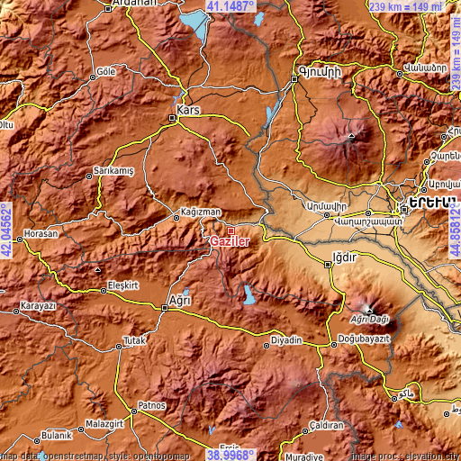
These maps also provides idea of topography and contour of this city, they are displayed at different zoom levels. More info about maps, scale and edge coordinates you can find below images.
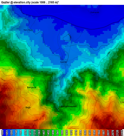
| \ | Map #1 | Topo.Map |
| Scale [m] | 1006..2165 m | × |
| Scale [ft] | 3301..7103 ft | × |
| Average | 1393.3 m = 4571 ft | × |
| Width | 7.48 km = 4.6 mi | 239.3 km = 148.7 mi |
| Height | 7.48 km = 4.6 mi | 239.3 km = 148.7 mi |
| ↑Max Latitude | 40.114866° | 41.1487° |
| Latitude at center | 40.08125° | 40.08125° |
| ↓Min Latitude | 40.047618° | 38.9968° |
| ← Min Longitude | 43.407925° | 42.04562° |
| Longitude center | 43.45187° | 43.45187° |
| →Max Longitude | 43.495815° | 44.85812° |
Nearby cities:
Cities around Gaziler sort by population:
• Ağrı elevation 1640 m
52.8 km,  220°
220°
• Iğdır 860 m
53.5 km,  109°
109°
• Kağızman 1276 m
28.3 km,  287°
287°
• Taşlıçay 1736 m
50.7 km,  188°
188°
• Karakoyunlu 1888 m
27.9 km,  147°
147°
• Başgedikler 1604 m
62.5 km,  5°
5°
• Suluçem 1750 m
53 km,  144°
144°
• Murat 1678 m
48.9 km,  201°
201°
• Kötek 1435 m
41.2 km, 291°
• Digor 1765 m
32.2 km,  353°
353°
• Cumaçay 1959 m
29.2 km,  230°
230°
• Tuzluca 1123 m
17.7 km, 105°
Multilingual:
 En español:
Gaziler elevación 1114 m.
 En France:
Gaziler élévation 1114 m.
 Auf Deutsch:
Gaziler höhe über dem Meeresspiegel ist 1114 m.

Sources and notes:
- [note 1] Map square and city borders are not equal. Map elevation data is calculated only from area inside that square.
- [src 1] Elevation data from geonames database provided with same terms of usage.
- [src 2] The elevation map of Gaziler is generated using elevation data from NASA's 3 arcsec (90m) resolution SRTM data.
- [src 3] Base (background) map © OpenStreetMap contributors tiles are generated by Geofabrik and OpenTopoMap.
Copyright & License:
This Gaziler Elevation Map is licensed under CC BY-SA. You may reuse any part from this page, if you give a proper credit by linking to this URL:
 More info on terms of use page.