Adana elevation
Adana, Turkey elevation is 41 meters and Adana elevation in feet is 135 ft above sea level [src 1]. Adana is a seat of a first-order administrative division (feature code) with elevation that is 682 meters (2238 ft) smaller than average city elevation in Turkey.
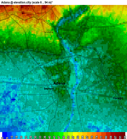
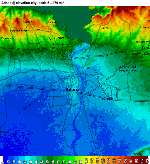
Below is the Elevation map of Adana, which displays elevation range with different colors. Scale of the first map is from 6 to 94 m (20 to 308 ft) with average elevation of 34.2 meters (=112 ft) [note 1]
These maps also provides idea of topography and contour of this city, they are displayed at different zoom levels. More info about maps, scale and edge coordinates you can find below images.
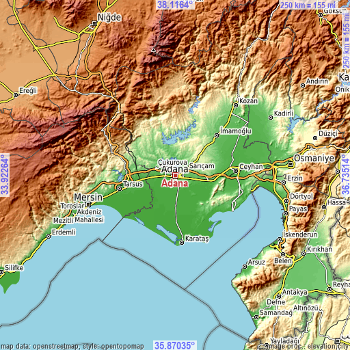
| \ | Map #1 | Map #2 | Topo.Map |
| Scale [m] | 6..94 m | 6..179 m | × |
| Scale [ft] | 20..308 ft | 20..587 ft | × |
| Average | 34.2 m = 112 ft | 47.9 m = 157 ft | × |
| Width | 7.8 km = 4.8 mi | 15.61 km = 9.7 mi | 249.7 km = 155.2 mi |
| Height | 7.8 km = 4.8 mi | 15.61 km = 9.7 mi | 249.7 km = 155.2 mi |
| ↑Max Latitude | 37.036757° | 37.071829° | 38.1164° |
| Latitude at center | 37.00167° | 37.00167° | 37.00167° |
| ↓Min Latitude | 36.966566° | 36.931447° | 35.87035° |
| ← Min Longitude | 35.284945° | 35.240999° | 33.92264° |
| Longitude center | 35.32889° | 35.32889° | 35.32889° |
| →Max Longitude | 35.372835° | 35.416781° | 36.73514° |
Nearby cities:
Cities around Adana sort by population:
• Tarsus elevation 21 m
39.9 km,  256°
256°
• İmamoğlu 85 m
41.3 km,  44°
44°
• Karaisalı 271 m
37.1 km,  319°
319°
• Tuzla 4 m
39.8 km,  212°
212°
• Sağkaya 59 m
37.5 km,  58°
58°
• Çatalan 147 m
27.7 km,  353°
353°
• Yakapınar 78 m
26.1 km,  96°
96°
• Yenice 31 m
24.7 km, 263°
• Sarıçam 303 m
23 km, 43°
• Doğankent 10 m
17.5 km,  175°
175°
• Yüreğir 24 m
4.1 km,  138°
138°
• Seyhan 23 m
2.6 km,  232°
232°
Multilingual:
 En español:
Adana elevación 41 m.
 En France:
Adana élévation 41 m.


Sources and notes:
- [note 1] Map square and city borders are not equal. Map elevation data is calculated only from area inside that square.
- [src 1] Elevation data from geonames database provided with same terms of usage.
- [src 2] The elevation map of Adana is generated using elevation data from NASA's 3 arcsec (90m) resolution SRTM data.
- [src 3] Base (background) map © OpenStreetMap contributors tiles are generated by Geofabrik and OpenTopoMap.
Copyright & License:
This Adana Elevation Map is licensed under CC BY-SA. You may reuse any part from this page, if you give a proper credit by linking to this URL:
 More info on terms of use page.