İmamoğlu elevation
İmamoğlu (Adana), Turkey elevation is 85 meters and İmamoğlu elevation in feet is 279 ft above sea level [src 1]. İmamoğlu is a seat of a second-order administrative division (feature code) with elevation that is 638 meters (2093 ft) smaller than average city elevation in Turkey.
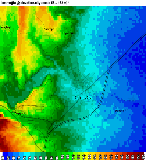
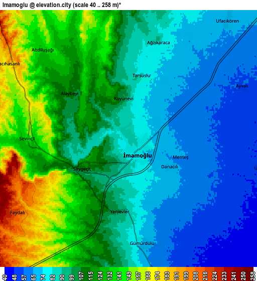
Below is the Elevation map of İmamoğlu, which displays elevation range with different colors. Scale of the first map is from 58 to 162 m (190 to 531 ft) with average elevation of 88.1 meters (=289 ft) [note 1]
These maps also provides idea of topography and contour of this city, they are displayed at different zoom levels. More info about maps, scale and edge coordinates you can find below images.
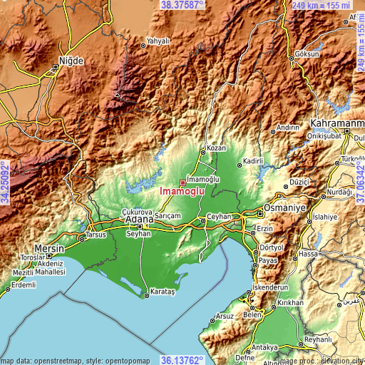
| \ | Map #1 | Map #2 | Topo.Map |
| Scale [m] | 58..162 m | 40..258 m | × |
| Scale [ft] | 190..531 ft | 131..846 ft | × |
| Average | 88.1 m = 289 ft | 101.5 m = 333 ft | × |
| Width | 7.78 km = 4.8 mi | 15.55 km = 9.7 mi | 248.9 km = 154.7 mi |
| Height | 7.78 km = 4.8 mi | 15.55 km = 9.7 mi | 248.9 km = 154.7 mi |
| ↑Max Latitude | 37.300025° | 37.334975° | 38.37587° |
| Latitude at center | 37.26506° | 37.26506° | 37.26506° |
| ↓Min Latitude | 37.230078° | 37.19508° | 36.13762° |
| ← Min Longitude | 35.613225° | 35.569279° | 34.25092° |
| Longitude center | 35.65717° | 35.65717° | 35.65717° |
| →Max Longitude | 35.701115° | 35.745061° | 37.06342° |
Nearby cities:
Cities around İmamoğlu sort by population:
• Adana elevation 41 m
41.3 km,  224°
224°
• Ceyhan 30 m
30.3 km,  151°
151°
• Kozan 140 m
25.4 km,  33°
33°
• Kadirli 82 m
40.7 km,  72°
72°
• Aladağ 896 m
39.1 km,  323°
323°
• Sumbas 116 m
38.4 km,  57°
57°
• Yakapınar 78 m
32.6 km,  185°
185°
• Çatalan 147 m
32.4 km,  266°
266°
• Kösreli 33 m
30.6 km,  111°
111°
• Sarıçam 303 m
18.3 km,  226°
226°
• Tepecikören 172 m
11 km,  345°
345°
• Sağkaya 59 m
10 km,  163°
163°
Multilingual:
 En español:
İmamoğlu elevación 85 m.
 En France:
İmamoğlu élévation 85 m.


Sources and notes:
- [note 1] Map square and city borders are not equal. Map elevation data is calculated only from area inside that square.
- [src 1] Elevation data from geonames database provided with same terms of usage.
- [src 2] The elevation map of İmamoğlu is generated using elevation data from NASA's 3 arcsec (90m) resolution SRTM data.
- [src 3] Base (background) map © OpenStreetMap contributors tiles are generated by Geofabrik and OpenTopoMap.
Copyright & License:
This İmamoğlu Elevation Map is licensed under CC BY-SA. You may reuse any part from this page, if you give a proper credit by linking to this URL:
 More info on terms of use page.