Kozan elevation
Kozan (Adana), Turkey elevation is 140 meters and Kozan elevation in feet is 459 ft above sea level [src 1]. Kozan is a seat of a second-order administrative division (feature code) with elevation that is 583 meters (1913 ft) smaller than average city elevation in Turkey.
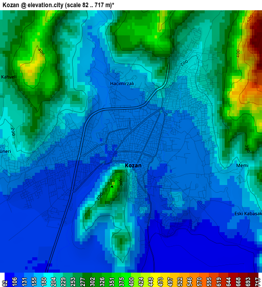
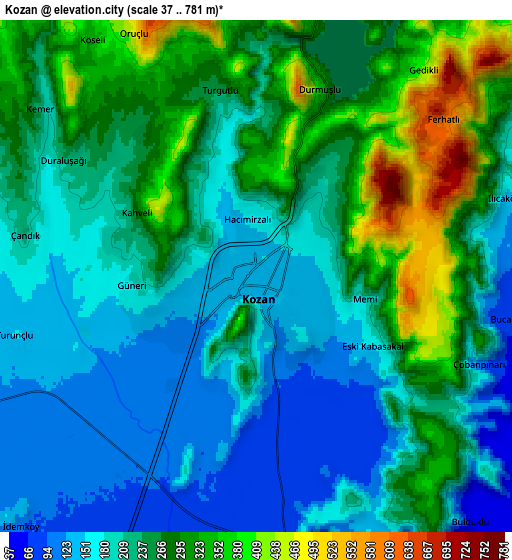
Below is the Elevation map of Kozan, which displays elevation range with different colors. Scale of the first map is from 82 to 717 m (269 to 2352 ft) with average elevation of 199.6 meters (=655 ft) [note 1]
These maps also provides idea of topography and contour of this city, they are displayed at different zoom levels. More info about maps, scale and edge coordinates you can find below images.
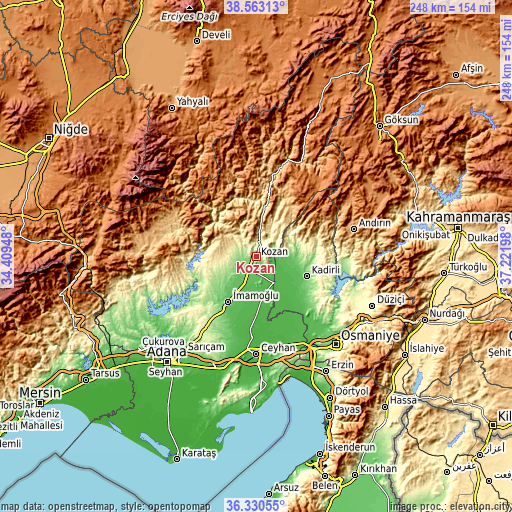
| \ | Map #1 | Map #2 | Topo.Map |
| Scale [m] | 82..717 m | 37..781 m | × |
| Scale [ft] | 269..2352 ft | 121..2562 ft | × |
| Average | 199.6 m = 655 ft | 235.6 m = 773 ft | × |
| Width | 7.76 km = 4.8 mi | 15.52 km = 9.6 mi | 248.2 km = 154.2 mi |
| Height | 7.76 km = 4.8 mi | 15.52 km = 9.6 mi | 248.2 km = 154.2 mi |
| ↑Max Latitude | 37.490047° | 37.524908° | 38.56313° |
| Latitude at center | 37.45517° | 37.45517° | 37.45517° |
| ↓Min Latitude | 37.420277° | 37.385367° | 36.33055° |
| ← Min Longitude | 35.771785° | 35.727839° | 34.40948° |
| Longitude center | 35.81573° | 35.81573° | 35.81573° |
| →Max Longitude | 35.859675° | 35.903621° | 37.22198° |
Nearby cities:
Cities around Kozan sort by population:
• Ceyhan elevation 30 m
47.9 km,  179°
179°
• Kadirli 82 m
26.4 km,  110°
110°
• İmamoğlu 85 m
25.4 km,  213°
213°
• Aladağ 896 m
38.4 km,  285°
285°
• Feke 552 m
40.8 km,  12°
12°
• Mansurlu 1007 m
46 km,  342°
342°
• Sarıçam 303 m
43.4 km,  218°
218°
• Tecirli 47 m
41.7 km,  141°
141°
• Kösreli 33 m
35.6 km,  156°
156°
• Sağkaya 59 m
32.8 km,  200°
200°
• Tepecikören 172 m
19.7 km,  238°
238°
• Sumbas 116 m
18.3 km,  91°
91°
Multilingual:
 En español:
Kozan elevación 140 m.
 En France:
Kozan élévation 140 m.


Sources and notes:
- [note 1] Map square and city borders are not equal. Map elevation data is calculated only from area inside that square.
- [src 1] Elevation data from geonames database provided with same terms of usage.
- [src 2] The elevation map of Kozan is generated using elevation data from NASA's 3 arcsec (90m) resolution SRTM data.
- [src 3] Base (background) map © OpenStreetMap contributors tiles are generated by Geofabrik and OpenTopoMap.
Copyright & License:
This Kozan Elevation Map is licensed under CC BY-SA. You may reuse any part from this page, if you give a proper credit by linking to this URL:
 More info on terms of use page.