Feke elevation
Feke (Adana), Turkey elevation is 552 meters and Feke elevation in feet is 1811 ft above sea level [src 1]. Feke is a seat of a second-order administrative division (feature code) with elevation that is 171 meters (561 ft) smaller than average city elevation in Turkey.
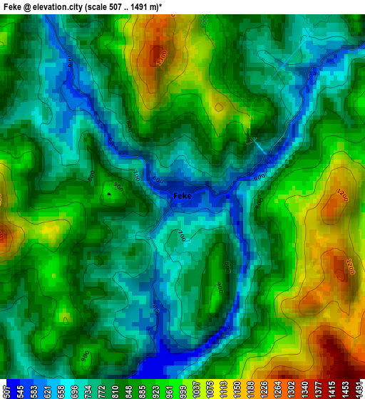
Below is the Elevation map of Feke, which displays elevation range with different colors. Scale of the first map is from 507 to 1491 m (1663 to 4892 ft) with average elevation of 851.5 meters (=2794 ft) [note 1]
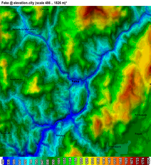
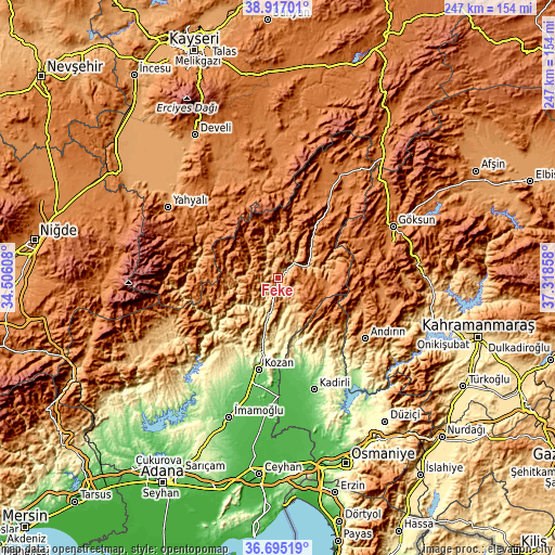
These maps also provides idea of topography and contour of this city, they are displayed at different zoom levels. More info about maps, scale and edge coordinates you can find below images.
| \ | Map #1 | Map #2 | Topo.Map |
| Scale [m] | 507..1491 m | 486..1826 m | × |
| Scale [ft] | 1663..4892 ft | 1594..5991 ft | × |
| Average | 851.5 m = 2794 ft | 963.1 m = 3160 ft | × |
| Width | 7.72 km = 4.8 mi | 15.44 km = 9.6 mi | 247 km = 153.5 mi |
| Height | 7.72 km = 4.8 mi | 15.44 km = 9.6 mi | 247 km = 153.5 mi |
| ↑Max Latitude | 37.849169° | 37.883861° | 38.91701° |
| Latitude at center | 37.81446° | 37.81446° | 37.81446° |
| ↓Min Latitude | 37.779735° | 37.744994° | 36.69519° |
| ← Min Longitude | 35.868385° | 35.824439° | 34.50608° |
| Longitude center | 35.91233° | 35.91233° | 35.91233° |
| →Max Longitude | 35.956275° | 36.000221° | 37.31858° |
Nearby cities:
Cities around Feke sort by population:
• Kozan elevation 140 m
40.8 km,  192°
192°
• Kadirli 82 m
51.6 km,  161°
161°
• Göksun 1344 m
56.2 km,  65°
65°
• Andırın 1047 m
47 km,  124°
124°
• Aladağ 896 m
54.2 km,  236°
236°
• Saimbeyli 982 m
24.7 km,  39°
39°
• Tufanbeyli 1427 m
56.7 km,  28°
28°
• Tepecikören 172 m
56.3 km,  206°
206°
• Bakırdağı 1318 m
45.9 km,  346°
346°
• Sumbas 116 m
41.5 km,  166°
166°
• Çokak 1240 m
37.6 km,  103°
103°
• Mansurlu 1007 m
23 km,  279°
279°
Multilingual:
 En español:
Feke elevación 552 m.
 En France:
Feke élévation 552 m.


Sources and notes:
- [note 1] Map square and city borders are not equal. Map elevation data is calculated only from area inside that square.
- [src 1] Elevation data from geonames database provided with same terms of usage.
- [src 2] The elevation map of Feke is generated using elevation data from NASA's 3 arcsec (90m) resolution SRTM data.
- [src 3] Base (background) map © OpenStreetMap contributors tiles are generated by Geofabrik and OpenTopoMap.
Copyright & License:
This Feke Elevation Map is licensed under CC BY-SA. You may reuse any part from this page, if you give a proper credit by linking to this URL:
 More info on terms of use page.