Mansurlu elevation
Mansurlu (Adana), Turkey elevation is 1007 meters and Mansurlu elevation in feet is 3304 ft above sea level [src 1]. Mansurlu is a seat of a third-order administrative division (feature code) with elevation that is 284 meters (932 ft) bigger than average city elevation in Turkey.
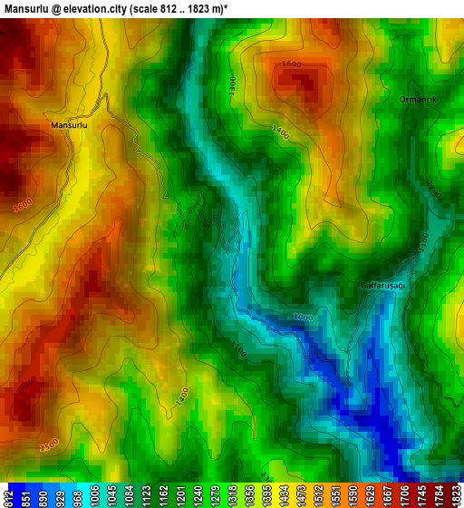
Below is the Elevation map of Mansurlu, which displays elevation range with different colors. Scale of the first map is from 812 to 1823 m (2664 to 5981 ft) with average elevation of 1315 meters (=4314 ft) [note 1]
These maps also provides idea of topography and contour of this city, they are displayed at different zoom levels. More info about maps, scale and edge coordinates you can find below images.
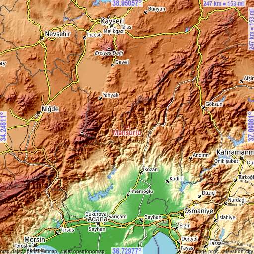
| \ | Map #1 | Topo.Map |
| Scale [m] | 812..1823 m | × |
| Scale [ft] | 2664..5981 ft | × |
| Average | 1315 m = 4314 ft | × |
| Width | 7.72 km = 4.8 mi | 246.9 km = 153.4 mi |
| Height | 7.72 km = 4.8 mi | 246.9 km = 153.4 mi |
| ↑Max Latitude | 37.883223° | 38.95057° |
| Latitude at center | 37.84853° | 37.84853° |
| ↓Min Latitude | 37.813821° | 36.72977° |
| ← Min Longitude | 35.610415° | 34.24811° |
| Longitude center | 35.65436° | 35.65436° |
| →Max Longitude | 35.698305° | 37.06061° |
Nearby cities:
Cities around Mansurlu sort by population:
• Kozan elevation 140 m
46 km,  162°
162°
• Develi 1260 m
61.9 km,  346°
346°
• İmamoğlu 85 m
64.9 km,  179°
179°
• Yahyalı 1180 m
38.4 km,  317°
317°
• Aladağ 896 m
40.4 km,  214°
214°
• Saimbeyli 982 m
41.2 km,  68°
68°
• Feke 552 m
23 km,  99°
99°
• Çokak 1240 m
60.6 km, 101°
• Çamardı 1482 m
59.1 km,  268°
268°
• Sumbas 116 m
54.8 km,  143°
143°
• Tepecikören 172 m
54.2 km, 182°
• Bakırdağı 1318 m
42.6 km,  16°
16°
Multilingual:
 En español:
Mansurlu elevación 1007 m.
 En France:
Mansurlu élévation 1007 m.
 Auf Deutsch:
Mansurlu höhe über dem Meeresspiegel ist 1007 m.

Sources and notes:
- [note 1] Map square and city borders are not equal. Map elevation data is calculated only from area inside that square.
- [src 1] Elevation data from geonames database provided with same terms of usage.
- [src 2] The elevation map of Mansurlu is generated using elevation data from NASA's 3 arcsec (90m) resolution SRTM data.
- [src 3] Base (background) map © OpenStreetMap contributors tiles are generated by Geofabrik and OpenTopoMap.
Copyright & License:
This Mansurlu Elevation Map is licensed under CC BY-SA. You may reuse any part from this page, if you give a proper credit by linking to this URL:
 More info on terms of use page.