Develi elevation
Develi (Kayseri), Turkey elevation is 1260 meters and Develi elevation in feet is 4134 ft above sea level [src 1]. Develi is a seat of a second-order administrative division (feature code) with elevation that is 537 meters (1762 ft) bigger than average city elevation in Turkey.
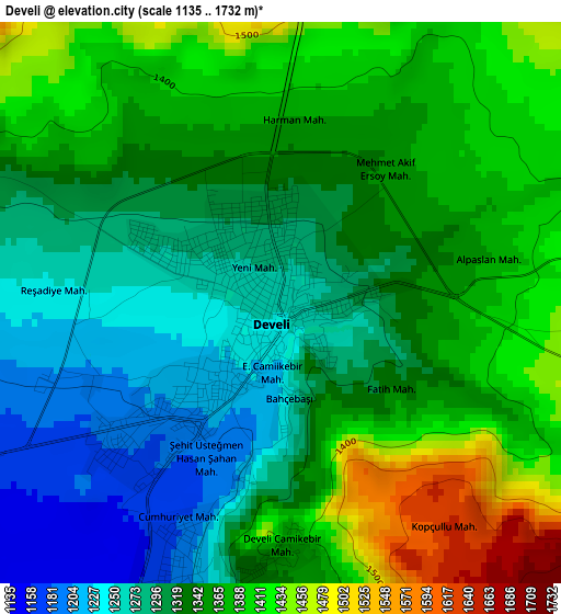
Below is the Elevation map of Develi, which displays elevation range with different colors. Scale of the first map is from 1135 to 1732 m (3724 to 5682 ft) with average elevation of 1340.1 meters (=4397 ft) [note 1]
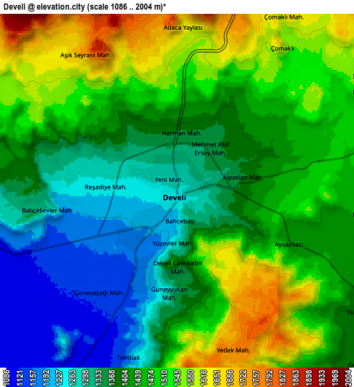
These maps also provides idea of topography and contour of this city, they are displayed at different zoom levels. More info about maps, scale and edge coordinates you can find below images.
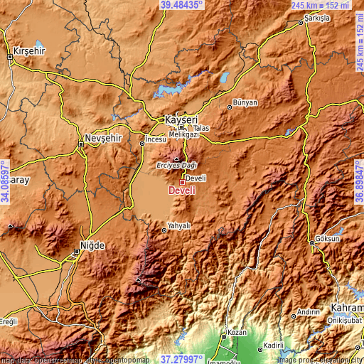
| \ | Map #1 | Map #2 | Topo.Map |
| Scale [m] | 1135..1732 m | 1086..2004 m | × |
| Scale [ft] | 3724..5682 ft | 3563..6575 ft | × |
| Average | 1340.1 m = 4397 ft | 1428.9 m = 4688 ft | × |
| Width | 7.66 km = 4.8 mi | 15.32 km = 9.5 mi | 245.1 km = 152.3 mi |
| Height | 7.66 km = 4.8 mi | 15.32 km = 9.5 mi | 245.1 km = 152.3 mi |
| ↑Max Latitude | 38.424996° | 38.459415° | 39.48435° |
| Latitude at center | 38.39056° | 38.39056° | 38.39056° |
| ↓Min Latitude | 38.356108° | 38.321639° | 37.27997° |
| ← Min Longitude | 35.448275° | 35.404329° | 34.08597° |
| Longitude center | 35.49222° | 35.49222° | 35.49222° |
| →Max Longitude | 35.536165° | 35.580111° | 36.89847° |
Nearby cities:
Cities around Develi sort by population:
• Kayseri elevation 1054 m
38 km,  359°
359°
• Talas 1153 m
33.8 km,  9°
9°
• Yahyalı 1180 m
34.2 km,  200°
200°
• Hacılar 1398 m
28.7 km,  352°
352°
• Yeşilhisar 1100 m
35.4 km,  263°
263°
• Tomarza 1394 m
27.5 km,  76°
76°
• Gesi 1204 m
46.9 km,  18°
18°
• Toklar 1449 m
45.7 km,  86°
86°
• Kocasinan 1085 m
42.9 km, 9°
• Melikgazi 1045 m
40.1 km, 354°
• İncesu 1101 m
37.3 km,  313°
313°
• Bakırdağı 1318 m
32.4 km,  126°
126°
Multilingual:
 En español:
Develi elevación 1260 m.
 En France:
Develi élévation 1260 m.


Sources and notes:
- [note 1] Map square and city borders are not equal. Map elevation data is calculated only from area inside that square.
- [src 1] Elevation data from geonames database provided with same terms of usage.
- [src 2] The elevation map of Develi is generated using elevation data from NASA's 3 arcsec (90m) resolution SRTM data.
- [src 3] Base (background) map © OpenStreetMap contributors tiles are generated by Geofabrik and OpenTopoMap.
Copyright & License:
This Develi Elevation Map is licensed under CC BY-SA. You may reuse any part from this page, if you give a proper credit by linking to this URL:
 More info on terms of use page.