Hacılar elevation
Hacılar (Kayseri), Turkey elevation is 1398 meters and Hacılar elevation in feet is 4587 ft above sea level [src 1]. Hacılar is a seat of a second-order administrative division (feature code) with elevation that is 675 meters (2215 ft) bigger than average city elevation in Turkey.
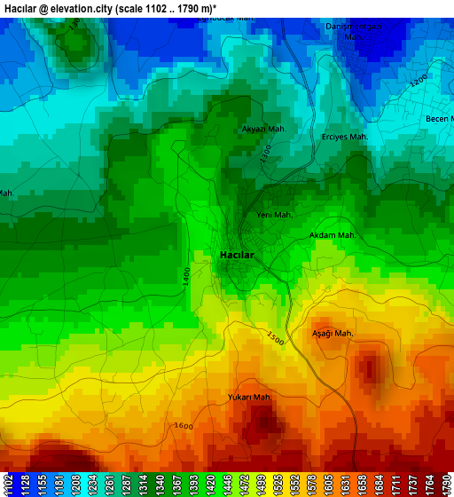
Below is the Elevation map of Hacılar, which displays elevation range with different colors. Scale of the first map is from 1102 to 1790 m (3615 to 5873 ft) with average elevation of 1405 meters (=4610 ft) [note 1]
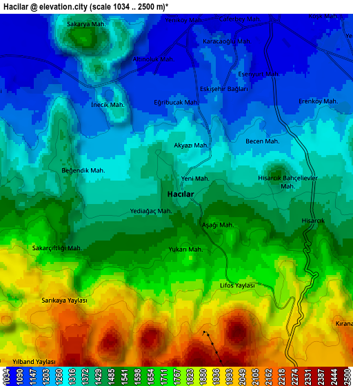
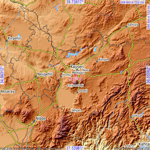
These maps also provides idea of topography and contour of this city, they are displayed at different zoom levels. More info about maps, scale and edge coordinates you can find below images.
| \ | Map #1 | Map #2 | Topo.Map |
| Scale [m] | 1102..1790 m | 1034..2500 m | × |
| Scale [ft] | 3615..5873 ft | 3392..8202 ft | × |
| Average | 1405 m = 4610 ft | 1499.8 m = 4921 ft | × |
| Width | 7.63 km = 4.7 mi | 15.27 km = 9.5 mi | 244.2 km = 151.7 mi |
| Height | 7.63 km = 4.7 mi | 15.26 km = 9.5 mi | 244.2 km = 151.7 mi |
| ↑Max Latitude | 38.680624° | 38.714921° | 39.73617° |
| Latitude at center | 38.64631° | 38.64631° | 38.64631° |
| ↓Min Latitude | 38.61198° | 38.577633° | 37.53961° |
| ← Min Longitude | 35.405425° | 35.361479° | 34.04312° |
| Longitude center | 35.44937° | 35.44937° | 35.44937° |
| →Max Longitude | 35.493315° | 35.537261° | 36.85562° |
Nearby cities:
Cities around Hacılar sort by population:
• Kayseri elevation 1054 m
10 km,  18°
18°
• Talas 1153 m
10.3 km,  61°
61°
• Develi 1260 m
28.7 km,  172°
172°
• Bünyan 1332 m
42 km, 58°
• Tomarza 1394 m
37.6 km,  126°
126°
• Himmetdede 1215 m
42.4 km,  313°
313°
• Muncusun 1217 m
32.4 km,  28°
28°
• Gesi 1204 m
24.4 km,  48°
48°
• İncesu 1101 m
23.3 km,  263°
263°
• Erkilet 1356 m
19.4 km,  357°
357°
• Kocasinan 1085 m
17.5 km,  37°
37°
• Melikgazi 1045 m
11.5 km,  0°
0°
Multilingual:
 En español:
Hacılar elevación 1398 m.
 En France:
Hacılar élévation 1398 m.
 Auf Deutsch:
Hacılar höhe über dem Meeresspiegel ist 1398 m.

Sources and notes:
- [note 1] Map square and city borders are not equal. Map elevation data is calculated only from area inside that square.
- [src 1] Elevation data from geonames database provided with same terms of usage.
- [src 2] The elevation map of Hacılar is generated using elevation data from NASA's 3 arcsec (90m) resolution SRTM data.
- [src 3] Base (background) map © OpenStreetMap contributors tiles are generated by Geofabrik and OpenTopoMap.
Copyright & License:
This Hacılar Elevation Map is licensed under CC BY-SA. You may reuse any part from this page, if you give a proper credit by linking to this URL:
 More info on terms of use page.