Yeşilhisar elevation
Yeşilhisar (Kayseri, Yesilhisar), Turkey elevation is 1100 meters and Yeşilhisar elevation in feet is 3609 ft above sea level [src 1]. Yeşilhisar is a seat of a second-order administrative division (feature code) with elevation that is 377 meters (1237 ft) bigger than average city elevation in Turkey.
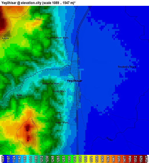
Below is the Elevation map of Yeşilhisar, which displays elevation range with different colors. Scale of the first map is from 1089 to 1547 m (3573 to 5075 ft) with average elevation of 1182.9 meters (=3881 ft) [note 1]
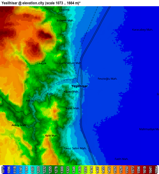
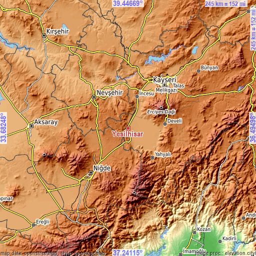
These maps also provides idea of topography and contour of this city, they are displayed at different zoom levels. More info about maps, scale and edge coordinates you can find below images.
| \ | Map #1 | Map #2 | Topo.Map |
| Scale [m] | 1089..1547 m | 1073..1664 m | × |
| Scale [ft] | 3573..5075 ft | 3520..5459 ft | × |
| Average | 1182.9 m = 3881 ft | 1227.5 m = 4027 ft | × |
| Width | 7.66 km = 4.8 mi | 15.33 km = 9.5 mi | 245.2 km = 152.4 mi |
| Height | 7.66 km = 4.8 mi | 15.33 km = 9.5 mi | 245.2 km = 152.4 mi |
| ↑Max Latitude | 38.386774° | 38.421212° | 39.44669° |
| Latitude at center | 38.35232° | 38.35232° | 38.35232° |
| ↓Min Latitude | 38.317849° | 38.283362° | 37.24115° |
| ← Min Longitude | 35.044785° | 35.000839° | 33.68248° |
| Longitude center | 35.08873° | 35.08873° | 35.08873° |
| →Max Longitude | 35.132675° | 35.176621° | 36.49498° |
Nearby cities:
Cities around Yeşilhisar sort by population:
• Kayseri elevation 1054 m
54.5 km,  39°
39°
• Nevşehir 1213 m
44.6 km,  312°
312°
• Develi 1260 m
35.4 km,  83°
83°
• Yahyalı 1180 m
36.4 km,  139°
139°
• Hacılar 1398 m
45.3 km, 43°
• Ürgüp 1067 m
34.5 km,  333°
333°
• Avanos 927 m
45.5 km, 332°
• Derinkuyu 1354 m
31 km,  274°
274°
• Göreme 1114 m
39.2 km, 325°
• Melikgazi 1045 m
54.2 km, 35°
• İncesu 1101 m
31.1 km,  15°
15°
• Misli 1315 m
30.4 km,  243°
243°
Multilingual:
 En español:
Yeşilhisar elevación 1100 m.
 En France:
Yeşilhisar élévation 1100 m.
 Auf Deutsch:
Yeşilhisar höhe über dem Meeresspiegel ist 1100 m.

Sources and notes:
- [note 1] Map square and city borders are not equal. Map elevation data is calculated only from area inside that square.
- [src 1] Elevation data from geonames database provided with same terms of usage.
- [src 2] The elevation map of Yeşilhisar is generated using elevation data from NASA's 3 arcsec (90m) resolution SRTM data.
- [src 3] Base (background) map © OpenStreetMap contributors tiles are generated by Geofabrik and OpenTopoMap.
Copyright & License:
This Yeşilhisar Elevation Map is licensed under CC BY-SA. You may reuse any part from this page, if you give a proper credit by linking to this URL:
 More info on terms of use page.