Ürgüp elevation
Ürgüp (Nevşehir), Turkey elevation is 1067 meters and Ürgüp elevation in feet is 3501 ft above sea level [src 1]. Ürgüp is a seat of a second-order administrative division (feature code) with elevation that is 344 meters (1129 ft) bigger than average city elevation in Turkey.
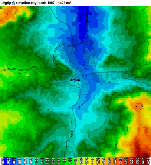
Below is the Elevation map of Ürgüp, which displays elevation range with different colors. Scale of the first map is from 1007 to 1422 m (3304 to 4665 ft) with average elevation of 1137.5 meters (=3732 ft) [note 1]
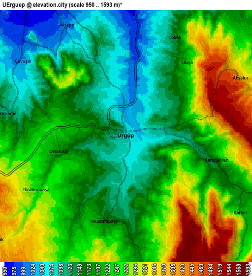
These maps also provides idea of topography and contour of this city, they are displayed at different zoom levels. More info about maps, scale and edge coordinates you can find below images.
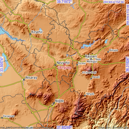
| \ | Map #1 | Map #2 | Topo.Map |
| Scale [m] | 1007..1422 m | 950..1593 m | × |
| Scale [ft] | 3304..4665 ft | 3117..5226 ft | × |
| Average | 1137.5 m = 3732 ft | 1212.4 m = 3978 ft | × |
| Width | 7.63 km = 4.7 mi | 15.27 km = 9.5 mi | 244.3 km = 151.8 mi |
| Height | 7.63 km = 4.7 mi | 15.27 km = 9.5 mi | 244.3 km = 151.8 mi |
| ↑Max Latitude | 38.663922° | 38.698227° | 39.71972° |
| Latitude at center | 38.6296° | 38.6296° | 38.6296° |
| ↓Min Latitude | 38.595262° | 38.560907° | 37.52265° |
| ← Min Longitude | 34.868045° | 34.824099° | 33.50574° |
| Longitude center | 34.91199° | 34.91199° | 34.91199° |
| →Max Longitude | 34.955935° | 34.999881° | 36.31824° |
Nearby cities:
Cities around Ürgüp sort by population:
• Nevşehir elevation 1213 m
17.4 km,  268°
268°
• Yeşilhisar 1100 m
34.5 km,  153°
153°
• Avanos 927 m
11.1 km,  329°
329°
• Derinkuyu 1354 m
32.3 km,  208°
208°
• Gülşehir 913 m
28 km,  297°
297°
• Acıgöl 1246 m
36.1 km,  255°
255°
• Göreme 1114 m
6.8 km,  283°
283°
• Topaklı 1206 m
42.5 km,  349°
349°
• Salanda 1018 m
39.5 km, 303°
• Himmetdede 1215 m
35.1 km,  27°
27°
• İncesu 1101 m
23.5 km,  91°
91°
• Özonak 1187 m
21.2 km,  343°
343°
Multilingual:
 En español:
Ürgüp elevación 1067 m.
 En France:
Ürgüp élévation 1067 m.


Sources and notes:
- [note 1] Map square and city borders are not equal. Map elevation data is calculated only from area inside that square.
- [src 1] Elevation data from geonames database provided with same terms of usage.
- [src 2] The elevation map of Ürgüp is generated using elevation data from NASA's 3 arcsec (90m) resolution SRTM data.
- [src 3] Base (background) map © OpenStreetMap contributors tiles are generated by Geofabrik and OpenTopoMap.
Copyright & License:
This Ürgüp Elevation Map is licensed under CC BY-SA. You may reuse any part from this page, if you give a proper credit by linking to this URL:
 More info on terms of use page.