Ceyhan elevation
Ceyhan (Adana), Turkey elevation is 30 meters and Ceyhan elevation in feet is 98 ft above sea level [src 1]. Ceyhan is a seat of a second-order administrative division (feature code) with elevation that is 693 meters (2274 ft) smaller than average city elevation in Turkey.
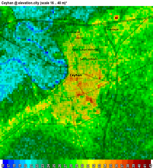
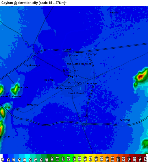
Below is the Elevation map of Ceyhan, which displays elevation range with different colors. Scale of the first map is from 16 to 40 m (52 to 131 ft) with average elevation of 25.8 meters (=85 ft) [note 1]
These maps also provides idea of topography and contour of this city, they are displayed at different zoom levels. More info about maps, scale and edge coordinates you can find below images.
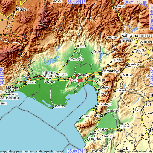
| \ | Map #1 | Map #2 | Topo.Map |
| Scale [m] | 16..40 m | 15..276 m | × |
| Scale [ft] | 52..131 ft | 49..906 ft | × |
| Average | 25.8 m = 85 ft | 29.9 m = 98 ft | × |
| Width | 7.8 km = 4.8 mi | 15.6 km = 9.7 mi | 249.7 km = 155.2 mi |
| Height | 7.8 km = 4.8 mi | 15.6 km = 9.7 mi | 249.7 km = 155.2 mi |
| ↑Max Latitude | 37.059797° | 37.094857° | 38.13911° |
| Latitude at center | 37.02472° | 37.02472° | 37.02472° |
| ↓Min Latitude | 36.989627° | 36.954518° | 35.89374° |
| ← Min Longitude | 35.773555° | 35.729609° | 34.41125° |
| Longitude center | 35.8175° | 35.8175° | 35.8175° |
| →Max Longitude | 35.861445° | 35.905391° | 37.22375° |
Nearby cities:
Cities around Ceyhan sort by population:
• Osmaniye elevation 128 m
38.6 km,  81°
81°
• İmamoğlu 85 m
30.3 km,  331°
331°
• Erzin 167 m
34.7 km,  103°
103°
• Toprakkale 70 m
29.6 km, 80°
• Mahmutlar 163 m
34.3 km, 104°
• Yüreğir 24 m
41.1 km,  262°
262°
• Sarıçam 303 m
30.9 km,  297°
297°
• Tecirli 47 m
30.1 km,  59°
59°
• Yumurtalık 19 m
28.6 km,  185°
185°
• Kösreli 33 m
20.9 km,  42°
42°
• Sağkaya 59 m
20.6 km, 326°
• Yakapınar 78 m
18.4 km,  251°
251°
Multilingual:
 En español:
Ceyhan elevación 30 m.
 En France:
Ceyhan élévation 30 m.


Sources and notes:
- [note 1] Map square and city borders are not equal. Map elevation data is calculated only from area inside that square.
- [src 1] Elevation data from geonames database provided with same terms of usage.
- [src 2] The elevation map of Ceyhan is generated using elevation data from NASA's 3 arcsec (90m) resolution SRTM data.
- [src 3] Base (background) map © OpenStreetMap contributors tiles are generated by Geofabrik and OpenTopoMap.
Copyright & License:
This Ceyhan Elevation Map is licensed under CC BY-SA. You may reuse any part from this page, if you give a proper credit by linking to this URL:
 More info on terms of use page.