Mahmutlar elevation
Mahmutlar (Hatay), Turkey elevation is 163 meters and Mahmutlar elevation in feet is 535 ft above sea level [src 1]. Mahmutlar is a section of populated place (feature code) with elevation that is 560 meters (1837 ft) smaller than average city elevation in Turkey.
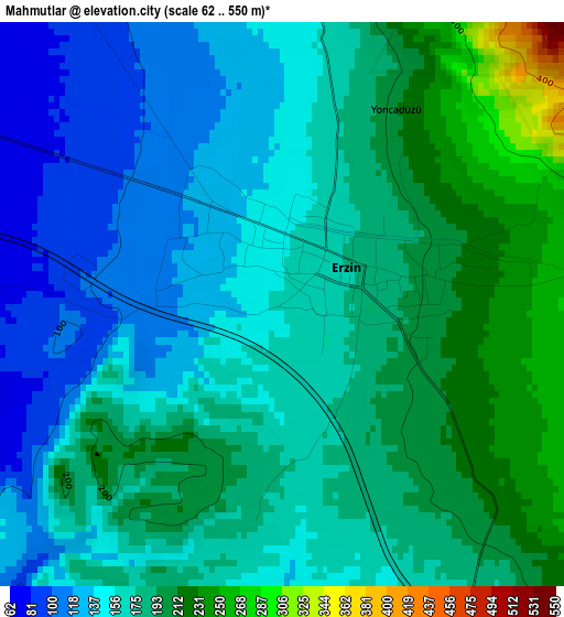
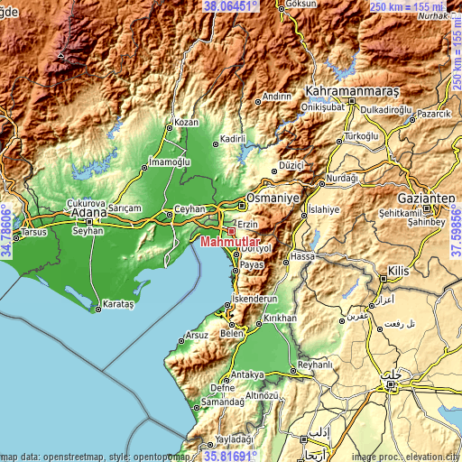
Below is the Elevation map of Mahmutlar, which displays elevation range with different colors. Scale of the first map is from 62 to 550 m (203 to 1804 ft) with average elevation of 170.8 meters (=560 ft) [note 1]
These maps also provides idea of topography and contour of this city, they are displayed at different zoom levels. More info about maps, scale and edge coordinates you can find below images.

| \ | Map #1 | Map #2 | Topo.Map |
| Scale [m] | 62..550 m | -2..1218 m | × |
| Scale [ft] | 203..1804 ft | -7..3996 ft | × |
| Average | 170.8 m = 560 ft | 225.7 m = 740 ft | × |
| Width | 7.81 km = 4.9 mi | 15.62 km = 9.7 mi | 249.9 km = 155.3 mi |
| Height | 7.81 km = 4.9 mi | 15.62 km = 9.7 mi | 249.9 km = 155.3 mi |
| ↑Max Latitude | 36.984112° | 37.019207° | 38.06451° |
| Latitude at center | 36.949° | 36.949° | 36.949° |
| ↓Min Latitude | 36.913872° | 36.878728° | 35.81691° |
| ← Min Longitude | 36.148365° | 36.104419° | 34.78606° |
| Longitude center | 36.19231° | 36.19231° | 36.19231° |
| →Max Longitude | 36.236255° | 36.280201° | 37.59856° |
Nearby cities:
Cities around Mahmutlar sort by population:
• Osmaniye elevation 128 m
14.8 km,  19°
19°
• Ceyhan 30 m
34.3 km,  284°
284°
• Dörtyol 79 m
12.7 km,  164°
164°
• Erzin 167 m
0.7 km,  47°
47°
• Denizciler 41 m
34.3 km,  176°
176°
• Hassa 431 m
33.4 km,  119°
119°
• Toprakkale 70 m
13.9 km,  343°
343°
• Kösreli 33 m
30.4 km,  321°
321°
• Kaypak 782 m
30.4 km, 52°
• Tecirli 47 m
24.8 km, 342°
• Yarpuz 974 m
23.9 km,  62°
62°
• Payas 32 m
21.5 km,  174°
174°
Multilingual:
 En español:
Mahmutlar elevación 163 m.
 En France:
Mahmutlar élévation 163 m.
 Auf Deutsch:
Mahmutlar höhe über dem Meeresspiegel ist 163 m.

Sources and notes:
- [note 1] Map square and city borders are not equal. Map elevation data is calculated only from area inside that square.
- [src 1] Elevation data from geonames database provided with same terms of usage.
- [src 2] The elevation map of Mahmutlar is generated using elevation data from NASA's 3 arcsec (90m) resolution SRTM data.
- [src 3] Base (background) map © OpenStreetMap contributors tiles are generated by Geofabrik and OpenTopoMap.
Copyright & License:
This Mahmutlar Elevation Map is licensed under CC BY-SA. You may reuse any part from this page, if you give a proper credit by linking to this URL:
 More info on terms of use page.