Dörtyol elevation
Dörtyol (Hatay, Dörtyol İlçesi), Turkey elevation is 79 meters and Dörtyol elevation in feet is 259 ft above sea level [src 1]. Dörtyol is a seat of a second-order administrative division (feature code) with elevation that is 644 meters (2113 ft) smaller than average city elevation in Turkey.
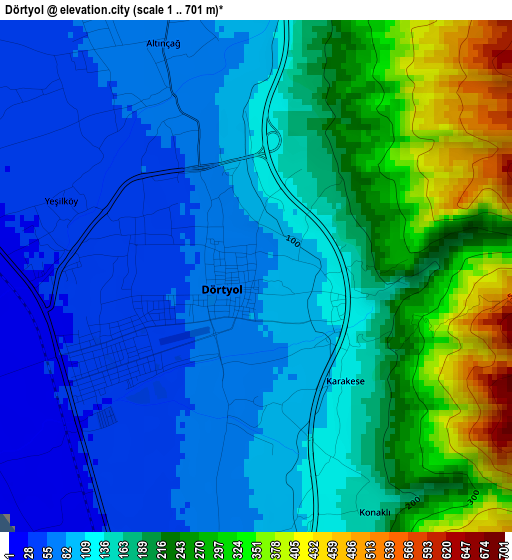
Below is the Elevation map of Dörtyol, which displays elevation range with different colors. Scale of the first map is from 1 to 701 m (3 to 2300 ft) with average elevation of 159.5 meters (=523 ft) [note 1]
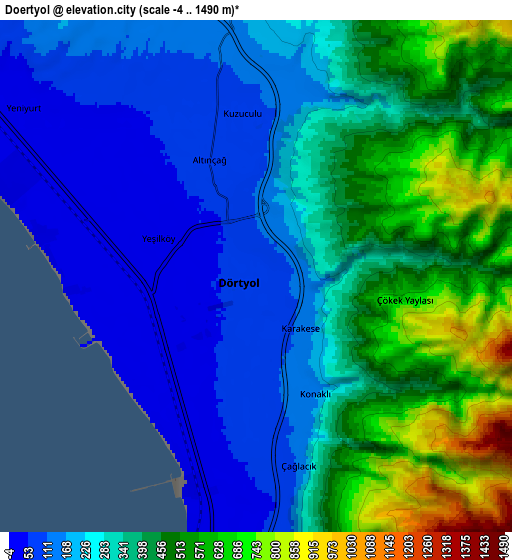
These maps also provides idea of topography and contour of this city, they are displayed at different zoom levels. More info about maps, scale and edge coordinates you can find below images.
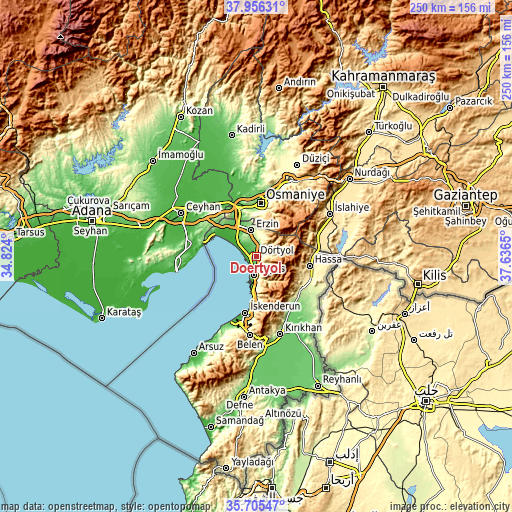
| \ | Map #1 | Map #2 | Topo.Map |
| Scale [m] | 1..701 m | -4..1490 m | × |
| Scale [ft] | 3..2300 ft | -13..4888 ft | × |
| Average | 159.5 m = 523 ft | 327.1 m = 1073 ft | × |
| Width | 7.82 km = 4.9 mi | 15.64 km = 9.7 mi | 250.3 km = 155.5 mi |
| Height | 7.82 km = 4.9 mi | 15.64 km = 9.7 mi | 250.3 km = 155.5 mi |
| ↑Max Latitude | 36.874332° | 36.909478° | 37.95631° |
| Latitude at center | 36.83917° | 36.83917° | 36.83917° |
| ↓Min Latitude | 36.803992° | 36.768797° | 35.70547° |
| ← Min Longitude | 36.186305° | 36.142359° | 34.824° |
| Longitude center | 36.23025° | 36.23025° | 36.23025° |
| →Max Longitude | 36.274195° | 36.318141° | 37.6365° |
Nearby cities:
Cities around Dörtyol sort by population:
• Osmaniye elevation 128 m
26.2 km,  3°
3°
• İskenderun 9 m
28.5 km,  190°
190°
• Erzin 167 m
13 km,  347°
347°
• Denizciler 41 m
22.1 km,  183°
183°
• Hassa 431 m
26 km,  99°
99°
• Toprakkale 70 m
26.6 km,  343°
343°
• Mahmutlar 163 m
12.7 km, 344°
• Aşağı Karafakılı 348 m
29.9 km, 102°
• Yarpuz 974 m
29.3 km,  37°
37°
• Aktepe 283 m
27.4 km,  123°
123°
• Gyuvench 523 m
24.2 km,  134°
134°
• Payas 32 m
9.4 km, 188°
Multilingual:
 En español:
Dörtyol elevación 79 m.
 En France:
Dörtyol élévation 79 m.


Sources and notes:
- [note 1] Map square and city borders are not equal. Map elevation data is calculated only from area inside that square.
- [src 1] Elevation data from geonames database provided with same terms of usage.
- [src 2] The elevation map of Dörtyol is generated using elevation data from NASA's 3 arcsec (90m) resolution SRTM data.
- [src 3] Base (background) map © OpenStreetMap contributors tiles are generated by Geofabrik and OpenTopoMap.
Copyright & License:
This Dörtyol Elevation Map is licensed under CC BY-SA. You may reuse any part from this page, if you give a proper credit by linking to this URL:
 More info on terms of use page.