Osmaniye elevation
Osmaniye, Turkey elevation is 128 meters and Osmaniye elevation in feet is 420 ft above sea level [src 1]. Osmaniye is a seat of a first-order administrative division (feature code) with elevation that is 595 meters (1952 ft) smaller than average city elevation in Turkey.
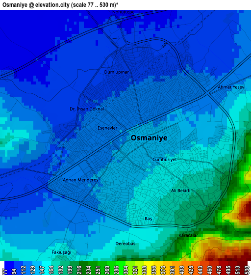
Below is the Elevation map of Osmaniye, which displays elevation range with different colors. Scale of the first map is from 77 to 530 m (253 to 1739 ft) with average elevation of 139.1 meters (=456 ft) [note 1]
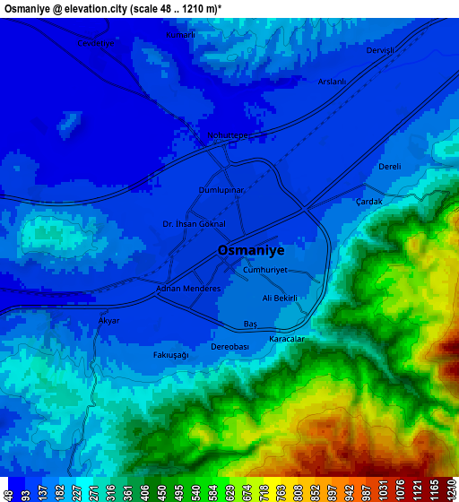
These maps also provides idea of topography and contour of this city, they are displayed at different zoom levels. More info about maps, scale and edge coordinates you can find below images.
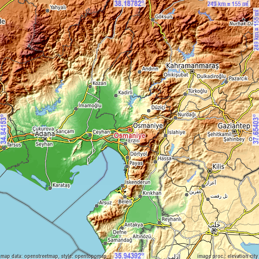
| \ | Map #1 | Map #2 | Topo.Map |
| Scale [m] | 77..530 m | 48..1210 m | × |
| Scale [ft] | 253..1739 ft | 157..3970 ft | × |
| Average | 139.1 m = 456 ft | 263.1 m = 863 ft | × |
| Width | 7.8 km = 4.8 mi | 15.59 km = 9.7 mi | 249.5 km = 155 mi |
| Height | 7.8 km = 4.8 mi | 15.59 km = 9.7 mi | 249.5 km = 155 mi |
| ↑Max Latitude | 37.109224° | 37.144262° | 38.18782° |
| Latitude at center | 37.07417° | 37.07417° | 37.07417° |
| ↓Min Latitude | 37.0391° | 37.004014° | 35.94392° |
| ← Min Longitude | 36.203835° | 36.159889° | 34.84153° |
| Longitude center | 36.24778° | 36.24778° | 36.24778° |
| →Max Longitude | 36.291725° | 36.335671° | 37.65403° |
Nearby cities:
Cities around Osmaniye sort by population:
• Dörtyol elevation 79 m
26.2 km,  183°
183°
• Erzin 167 m
14.1 km,  198°
198°
• Bahçe 628 m
32.2 km,  64°
64°
• Toprakkale 70 m
9 km,  266°
266°
• Hasanbeyli 723 m
27.1 km,  77°
77°
• Mahmutlar 163 m
14.8 km, 199°
• İslahiye 523 m
34.4 km,  99°
99°
• Haruniye 389 m
26.2 km,  44°
44°
• Kösreli 33 m
25.8 km,  292°
292°
• Kaypak 782 m
19.8 km, 76°
• Yarpuz 974 m
16.5 km, 100°
• Tecirli 47 m
15.6 km,  308°
308°
Multilingual:
 En español:
Osmaniye elevación 128 m.
 En France:
Osmaniye élévation 128 m.
 Auf Deutsch:
Osmaniye höhe über dem Meeresspiegel ist 128 m.

Sources and notes:
- [note 1] Map square and city borders are not equal. Map elevation data is calculated only from area inside that square.
- [src 1] Elevation data from geonames database provided with same terms of usage.
- [src 2] The elevation map of Osmaniye is generated using elevation data from NASA's 3 arcsec (90m) resolution SRTM data.
- [src 3] Base (background) map © OpenStreetMap contributors tiles are generated by Geofabrik and OpenTopoMap.
Copyright & License:
This Osmaniye Elevation Map is licensed under CC BY-SA. You may reuse any part from this page, if you give a proper credit by linking to this URL:
 More info on terms of use page.