Bahçe elevation
Bahçe (Adana), Turkey elevation is 628 meters and Bahçe elevation in feet is 2060 ft above sea level [src 1]. Bahçe is a populated place (feature code) with elevation that is 95 meters (312 ft) smaller than average city elevation in Turkey.
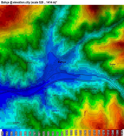
Below is the Elevation map of Bahçe, which displays elevation range with different colors. Scale of the first map is from 528 to 1414 m (1732 to 4639 ft) with average elevation of 839.3 meters (=2754 ft) [note 1]
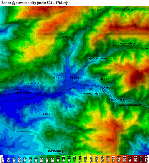
These maps also provides idea of topography and contour of this city, they are displayed at different zoom levels. More info about maps, scale and edge coordinates you can find below images.
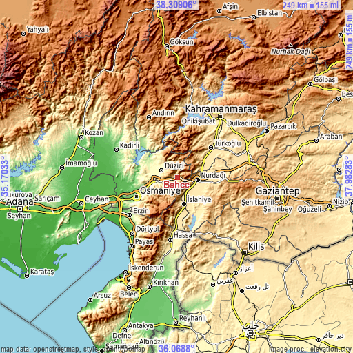
| \ | Map #1 | Map #2 | Topo.Map |
| Scale [m] | 528..1414 m | 508..1786 m | × |
| Scale [ft] | 1732..4639 ft | 1667..5860 ft | × |
| Average | 839.3 m = 2754 ft | 996.1 m = 3268 ft | × |
| Width | 7.78 km = 4.8 mi | 15.57 km = 9.7 mi | 249.1 km = 154.8 mi |
| Height | 7.78 km = 4.8 mi | 15.57 km = 9.7 mi | 249.1 km = 154.8 mi |
| ↑Max Latitude | 37.232237° | 37.267218° | 38.30906° |
| Latitude at center | 37.19724° | 37.19724° | 37.19724° |
| ↓Min Latitude | 37.162227° | 37.127197° | 36.0688° |
| ← Min Longitude | 36.532635° | 36.488689° | 35.17033° |
| Longitude center | 36.57658° | 36.57658° | 36.57658° |
| →Max Longitude | 36.620525° | 36.664471° | 37.98283° |
Nearby cities:
Cities around Bahçe sort by population:
• Osmaniye elevation 128 m
32.2 km,  244°
244°
• Nurdağı 486 m
14.5 km,  102°
102°
• Toprakkale 70 m
40.7 km,  249°
249°
• Hasanbeyli 723 m
8.1 km,  199°
199°
• Tecirli 47 m
41.5 km,  264°
264°
• Türkoğlu 561 m
31.6 km,  48°
48°
• Sakçagöz 694 m
30.2 km, 95°
• Yarpuz 974 m
21 km,  217°
217°
• İslahiye 523 m
19.7 km,  165°
165°
• Kaypak 782 m
13.5 km,  227°
227°
• Fevzipaşa 549 m
12.7 km,  154°
154°
• Haruniye 389 m
11.9 km,  294°
294°
Multilingual:
 En español:
Bahçe elevación 628 m.
 En France:
Bahçe élévation 628 m.


Sources and notes:
- [note 1] Map square and city borders are not equal. Map elevation data is calculated only from area inside that square.
- [src 1] Elevation data from geonames database provided with same terms of usage.
- [src 2] The elevation map of Bahçe is generated using elevation data from NASA's 3 arcsec (90m) resolution SRTM data.
- [src 3] Base (background) map © OpenStreetMap contributors tiles are generated by Geofabrik and OpenTopoMap.
Copyright & License:
This Bahçe Elevation Map is licensed under CC BY-SA. You may reuse any part from this page, if you give a proper credit by linking to this URL:
 More info on terms of use page.